I believe in such a thing as "Pyrolysis by Analysis" which is doing so much planning, that nothing gets done. On my farm I often say, "I always do what I say, it just takes awhile." That is because I plan things out far in advance. The things I am doing today, were planned out 10 years ago. It is not that I am lazy or procrasternating, but because my plan encompasses a lot.
One way I plan, is with scale models. This is not a perfect example because in trying to allow a side by side comparison of Google Satelite to my model, things get screwy as far as views go. But hopefully I can describe how I make a scale model, and why.
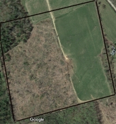
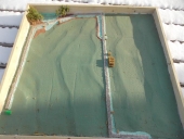
To start, the model allows me to quickly show the soil engineer, conservationist, etc what my overall vision is. If you look at the map of Google Earth on the left, you will see the logging road that stretches to the far end of the field, my sawmill in the middle etc, but in my model I have another road extending to the left on the upper part of the picture, then coming back down. (The green thing is a Monopoly house which represents where our off grid home will be). Without the model, I would have to describe a lot regarding where and how the road will eventually go. With a model, you instantly see it.
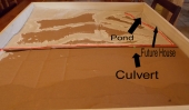
The model is also to contour scale. I use LIDAR here and 2 foot elevations, but admit it is hard to detect in the picture. Slopes here are 3-9 percent. To get that, I cut cardboard and glue them up in layers to form my hills and valleys. To eleminate the "steps", I simply spread out drywall compound to give me a very accurate contour of the land. This alone will show you where natural swales should go, keyline planning, Yeoman plowing, etc...
From there I add my earthwork elements. In this model, my gravel roads are depicted by glueing down railroad model ballast. The swales are painted in blue and raised by using drywall compound. The ditches of the swales are painted blue to represent water. For fun I added some big round bales in my model where my sawmill is located on the Google Earth Map (the whitish thing in the center of the photo). It is hard to distinguish in teh photo, but the brown blocks in the swales/ditches are where my square haybale check dams would be, as part of my planning is controlling water and stopping erosion. The last part of my model in the upper left corner depicts some trees where I want to build a pond and some campsites. Perhaps to rent out, but for now when we do our Rock the Flock event.
It is not a perfect method, but it is a lot cheaper to lay things out by scale now then rearrange roads, swales, and other earthworks later.
Swales.jpg
Comparison between a scale contour model of projected earthworks as compared to Google Maps
This is a youtube view standing at the spot we want to put our off-grid home (where the green Monopoly house is located), looking out in what would be left to right in the photos of the model/goodle earth. I wish the orientation was North/South, however I need some elevation to get a view of the area.
No prison can hold Chairface Chippendale. And on a totally different topic ... my stuff:
The Backyard Bread & Pizza Oven eBook by Teri Page and Brian Thomas


.png)
 1
1


![[Thumbnail for Swales.jpg]](/t/100602/a/70538/Swales.jpg "Filename: Swales.jpg
Description: Comparison between a scale contour model of projected earthworks as compared to Google Maps")