Weather and Health Effects: Fronts crossing the area
When a front crosses the area, I and others often react to it with pain or health issues. As I write this, it’s currently 5:00 AM on 9/21/18, I woke up in pain at 3:10, gave up and got out of bed at 4:00. I figured I would do so, knew the front was coming. I notice that my neighbors on each side here are both awake too. They are both in wheelchairs and can’t get out, which is the only reason we don't do “up all night from weather poker parties” since all three of us react about the same.
Why would it possibly be useful to know about this? What are we feeling, and how can you tell if you react to it too? Can this be used as an asset in your life? What exactly do I mean by “a front crossing the area?” How do you tell it’s coming?
It’s useful to know if this may be a factor in your health, because it gives you information to debug complex health problems. If your hip hurts sometimes, and you are trying to figure out why, knowing if it hurts worse when the weather is affecting it is a great data point to have. It makes random pain a little less random, a little less scary, and easier to schedule around. I knew this front was coming, I went to bed earlier than usual last night, knowing I’d be up earlier. I also have projects I’m working on ready to go for today, made sure yesterday I had all the things I need to do them, because I doubt I’ll be up for going out anyplace today. I have other health factors going on that are going to make this more painful than it normally would be that I’m taking into account too.
At 3:10 AM today I woke up with my normal baseline pain elevated. I felt it most in my back, knees and neck, which made me hurt to lay in bed, so I got up at 4. All of my usual inflammation is hurting, and due to chronic sinus damage, it’s increasing sinus drainage, which is impeding my breathing, resulting in low oxygen level effects making my adrenals react in panic. So I’m agitated, I can't breathe, I hurt all over, the excess drainage is upsetting my stomach (as are the meds I took this morning) and my knee pain makes walking difficult. That’s me, this morning. Anyone else, it would affect any areas that are inflamed, depending on your health issues. Any area that has been injured or has scar tissue often hurts. Lyme and similar illnesses often have systemic inflammation (through the whole body) so it would be quite likely to hurt all over, or have a flare up of your usual symptoms.
I saw this front coming a few days ahead, I started increasing my anti-inflammatory vitamins and herbs, (turmeric, ginger) increased my anti-infection stuff, (liposomal Vit C, D3, Vit A, olive leaf, garlic) increased my water intake (helps flush out lactic acid, which complicates joint pain) and made sure I had what I needed to do the work I plan to do today, and went to bed early. It won’t be too bad. If I didn’t have the complications that are currently going on, I probably wouldn’t have expected to react this bad for a small front, this is what I usually do for a major storm system. The complications are going to increase all of the reactions though, and I have work I want to do.
Being aware of this makes it less random to go to bed and wake up in pain, panic, and stomach upset. If I didn’t know it was just that front walking over, I’d wonder if I had food poisoning or had caught something from someone yesterday while I was out. It gives me a way to understand the random feeling fluctuations. Since I know how to watch the weather, I choose my reaction, not letting that low oxygen panic cause hysteria because my body is apparently randomly crashing. It’s not random. It’s predictable, and I can choose my reaction to it. That’s an amazing power to have!
As a permaculture type, if you are sensitive to this it can be used to help you predict weather changes. On the examples coming up, you’ll see a 20+ degree temperature drop. If you have no way to check the weather, it’s late fall, and you suddenly feel a front coming in, you know to check that your plants and animals are ready for the temperature drop that’s coming. Some people watch the sky (I do that too) but I have a very accurate weather prediction center in my body! Pay attention, learn what it means to you when the weather changes, and you have a new tool in your toolkit!
This is what I watch, and why, and links I use:
I was planning to write about this, when I saw a nice basic front coming through I started taking notes so it would be easy to explain. This is not a bad one, it’s just a nice clear one that happened at the right time to be a good example.
A front is the big red or blue lines you see on the weather maps, often with rain along it. It’s where one air mass is pushing against another, with pressure, temperature changes, and those changes make humidity condense into rain. Usually there’s a cloud bank right along the edge of the front, often rain, and other storm results. The wind of the air mass moving often results in tornadoes and other wind events. It also changes the barometric pressure. A lot (but not all) of the effects of a front are due to the barometric pressure changes.
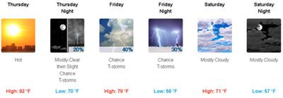
When you look at your weather forecast and it goes from sunny and warm to rainy and cool like this, there’s often a front coming in. I saw that on the forecast Thursday morning and loaded a map.

Yep, there it is, that may be coming down toward me in Missouri.
A site I like a lot is
Windy.com It animates the predicted winds and pressures (probably does more, that’s all I usually look at there) so I watched what they said it was going to do.
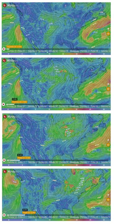
You can see the pressure moving in a lump, the main effect moving northeast across the country. Where I am, I won’t get the main lump, I’ll get the southern edge as it goes past.
I also looked at the hourly forecast at
weather.gov
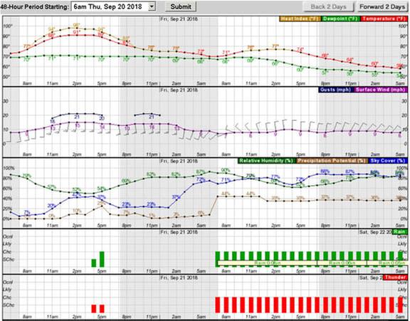
I can see that the wind is going to change speed and direction starting somewhere around 2 AM, that tells me the leading edge of the front will be starting to hit then, also gives me a good guess of when I’ll wake up! I wish they put barometric pressure on that graph.
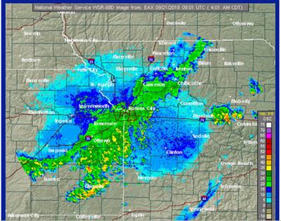
The leading edge is the part that crosses over first. If you think of a front as a wave of air just like a wave of water, the leading edge is where the water is starting to rise in the front, before the rest of it comes. I marked it on this picture.
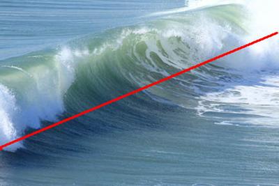
Water and air waves are the same physics, just in different places, the part of the wave that you see in this picture starting to crash over the top would be the storm line if it was an air front. Where the air is stirred up, just like that water crashing around, the air crashes around, causing rain. At 4 AM the leading edge of this was in the Kansas City area.
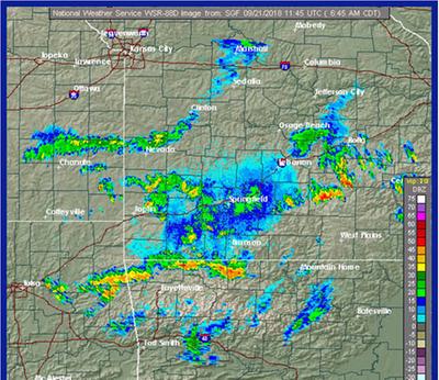
By 7AM the edge has passed the red line of Interstate 40 moving southeast, and is making the heavy rain areas that are red and orange. The rain line southeast of Kansas City is the basic rain that follows the leading edge. The temperature will be dropping soon behind it, since it’s that kind of weather pattern. Since it’s 7AM here, that means it just wont warm up today. Yesterday was 92 degrees plus 70% humidity, tonight will be in the mid 50s. It’s a cold front passing over us, bringing rain squalls. If you hear the weatherman say that, this is what he means. Now you know what it means to your health!
The leading edge is where the pressure starts changing, and where I start hurting or getting sick. Depending on how your body reacts to pressure changes, at this point it may be an hour or two, or a day or more, before the pain recedes. The post before this, Barometric Pressure and Health Effects explains this in more detail.
If you didn’t see it coming, and are wondering if what made you hurt was possibly the weather, this is what a graph of a quick front looked like. A bigger front the effect would have lasted longer, this one was a good example so you know what you may be looking for. This not the one from today.
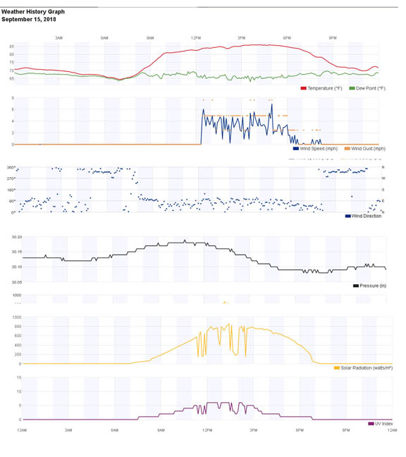
From the top:
First section is temperatures. Red line is the temperature, it stayed steady. The green one with it is the dew point, not important to this discussion.
Next section is the wind, blue is wind speed, orange wind gusts. See how there was almost no wind, then all of a sudden quite a lot, that’s often a front. The leading edge on this one was really sharp. It’s not always quite that abrupt.
Next section is wind direction. It changed from “kind of from the northish” to “definitely from the north.” And went back to less focused when the wind speed went down.
The next section is barometric pressure, the black line drops at the same time the wind speed comes up. That’s a definite front. On the barometric pressure thread I talk of how I judge the pressure drop. I would call that 7 points down, over about 5 hours, probably not going to be painful to me.
The next two sections are solar radiation (orange line) and UV index (purple line.) They show how bright the sun was, the deep dips are clouds going past, so what you are seeing there is the clouds that came in with this front. This one didn’t rain, it just blew across, bringing some clouds with it that left with it too.
That chart came off of a personal weather station that someone is running about 4 miles south of me. If you want to find if there’s one in your area, go to WUnderground
https://www.wunderground.com/ put in your location, find one close to you. The Change option will show them.
Edit: They have changed their view, try the history tab. I am leaving my original text here in green, in case your local station can do this, seems some can, some can't, it's really the best view.
{ The view is generally the forecast, the good charts are in the dashboard view. Look at the URL for the page you are on, see the bit at the end with letters and numbers? The K or W means it’s a broadcasting station, the next 2 letters are the state, the next is the town, then number of the station. The one I’m looking at is one near where I used to live: These didn't want to be links, but I can't make them not be. Don't click, read what's here. You CAN click, if you care what's happening in New Mexico, but it's not relevant :)
https://www.wunderground.com/weather/us/nm/las-cruces/KNMLASCR97 KNMLASCR97 being the number we are looking for. Copy the number and change the URL to https://www.wunderground.com/personal-weather-station/dashboard?ID=KNMLASCR97 (with your own number in it) and you’ll get to the graph view. Bookmark it, so you don’t have to mess with that again. I hate their forecast view, but their graph view is the best I have found. }
That graph view is the one I look at the most, I have it on my phone too, I can see the patterns of what the weather is doing. A number like 30.02 pressure doesn’t tell me much, where seeing it is going up or down tells me a lot.
I have one section in my browser bookmarks I labeled Weather Tabs. I tell it to Open All In Tabs, and flip through them quickly. It’s not a lot of effort for me to get a pretty accurate snapshot of the current weather, and guess of where it’s going. My weather tabs are:
Weather.gov
Weather.gov local radarWeather.gov local forecastWeather.gov local hourly forecast
WUnderground
The closest WUnderground local personal station set to dashboard view
The others I keep easy to reach, but don’t have on the tabs to open all the time are:
Other WUnderground local personal stations, set to dashboard view
https://www.wunderground.com/maps/current-weather/mixed-surface-analysis
surface analysis
Windy.com
Windy.com I keep the barometric pressure lines showing on it, as well as wind
What have you noticed happens when the weather changes? What have you learned to watch for in the weather report? I’d love to hear other people’s experiences! I have learned this mostly on my own, and always want to know more. I’m an information vacuum! :)
A companion thread to this one where we talk more about how we are affected by weather is
Sensitive to barometric pressure? What are your symptoms? 


 18
18


Skill verified by Nicole Alderman")

Skill verified by Mike Haasl")

Skill verified by Mike Haasl")