TO: C. Sanct, Chrissy Star, Joseph Lofthouse
FROM: Eric Koperek =
erickoperek@gmail.com
SUBJECT: "Keypoints" in Keyline Watershed Management
DATE: PM 7:42 Wednesday 31 August 2016
TEXT:
Please excuse my delay in responding to your questions; I have many clients and 90,000 acres of farmland to manage. Consequently, my response time is often measured in days or even weeks.
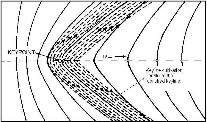
(1) Chrissy Star has posted a classic drawing of a "Keypoint". Unfortunately, watersheds rarely conform to textbook drawings. In practice, it is difficult to accurately locate a "keypoint" within several hundred feet of elevation in most real world circumstances. DON'T WORRY ABOUT IT.
(2) The concept rather than exactitude, is what is important.
(3) Imagine a steep slope merging with a more gentle grade. Where steep meets shallow is your "keypoint".
(4) Functionally, the "keypoint" is the first place where it is practical to build a dam as far up a watershed as possible. Build the dam at higher elevation and you won't collect enough water (and engineering becomes painfully expensive). Build the dam lower and you will need a larger structure (which increases costs). Also: The lower in elevation you build a dam, the less "head" you have to work with = water pressure is lower and the amount of land that can be irrigated by gravity is greatly reduced.
(5) Where to locate dams is both an art and science. The best way to learn this is by walking your land. A few quick calculations of area and rainfall will give you a good approximation of how much water you can collect from a slope (watershed) of known dimension. Everything that follows is Tinkertoy engineering.
(6) The primary concept of Keyline watershed management is to build small dams wherever practical to store water for flood irrigation of fields and pastures at lower elevation. Many dams over an area of range land can significantly alter local micro-climate and dramatically increase forage production.
(7) There are other ways to approach this problem. You can build "tanks" = ponds with porous bottoms designed to recharge aquifers. The idea is not to store surface water for any length of time but to get the water underground as quickly as possible. This technology is thousands of years old and originates in India. Read about Vedic agriculture.
(

Another solution is to dig trenches every 50 feet along contour lines. Use a trenching machine and dig as deep as machinery allows. Trenches intercept runoff and conduct water deep into subsoil for storage and aquifer recharge. Again, the idea is to get the water underground as fast as possible to prevent significant evaporation losses.
(9) You can employ similar tactics in wadis = arroyos = canyons = gullies = coulees = gullies = washes = any intermittent stream bed. Build check dams = weirs every 50 to 100 yards approximately (according to slope and availability of rocks). Dig trenches 1 to 2 feet wide and as deep as possible every 50 feet across stream beds. Weirs slow water flow and trenches conduct water into subsoil for storage. The idea is to trap every drop of water that flows into a wadi system. Get the water underground as fast as possible.
(10) Key Concept: Agriculture in arid and semi-arid climates is all about managing UNDERGROUND WATER. Replenish aquifers = raise water tables and crops, trees, and pastures will thrive.
(11) Note: Most canyons have underground streams close to the surface. These under-surface waterways can flow 5 years between rains. Underground streams allow trees to thrive in drought conditions.
(12) Most Americans have never heard of "horizontal wells". These are similar in concept to ancient "qanats" found in Persia and throughout the Middle East. The modern interpretation is to bore a hole into a mountainside and let gravity deliver the water for you. This largely eliminates the need for vertical wells and pumps. Dig contour trenches on slopes at higher elevation and you can turn every hillside into a giant water collection system (much like a tent or a building roof). Every inch of rain will yield about 2/3 gallon of water per square foot of relatively impermeable surface area (like steep, rocky slopes). Capture this water with trenches = get it underground fast and your horizontal bores will run year-round without attention. Let Nature and gravity do the work for you.
(13) Contact me if you have any questions or require further assistance.
ERIC KOPEREK =
erickoperek@gmail.com
end comment


 1
1