

|

|
|
|
|
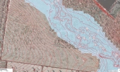
Dillon Nichols wrote:The center of the cleared 'boot' where the contours turn east-west, and the toe where things flatten out, look interesting.
Various gotchas that come to mind for those sites...
How are you planning to access the water in the dam if setting up on the far side of the creek?
Where is that dam water going, if the dam goes? Earthquake country?
What are the neighbours near that border like? Likely to change drastically?
Any concerns about having a really long driveway? (or powerlines, if you were planning on any?)
Hope you will share more info about your duck planning, sure there would be good interest.
bernetta putnam wrote:that much water near me I would build on the highest elevation of the land, and place my fields n plants between me and all that water.
F Agricola wrote:To clarify, the only access to the property is via a road that connects to the southwest corner, making the portion of the property on the north side if the creek inaccessible during floods?
Also, what are the contour intervals? The intervals for each plan appears to be different?
Dillon Nichols wrote:It depends.
What do you want to do on the land? What sort of area will this occupy? How much water will this need, and what are your options; groundwater? Able to pull from creek?
What is the soil like? Better near the creek?
Is that an annual flood line, or hundred year, or ?
So the driveway runs down the left side with some spurs leading in, and connection to road is at the top left?