tom stanis

+ Follow
since Jun 27, 2023
Merit badge: bb list bbv list
For More
Apples and Likes
Apples
Total received
In last 30 days
0
Forums and Threads

Recent posts by tom stanis

hans muster wrote:If you are afraid of pigs destroying stone walls you build to slow down the water, have you thought of wire basket gabions? If built close enough from each other, they slow down the water and buffer water discharge.

As said above, this will not replace a vegetated uphill area, but may help.


Yes. I've seen these wire baskets structures/ encased "riprap" around the area.  So Haiti actually has a "rural water agency" called DINEPA who builds systems similar to what we are pursuing but their followup management leaves much to be desired.  DINEPA's entire funding comes from the American Centers for Disease Control.  I'll give DINEPA props though.  they did build a water system almost identical to the system I designed for the same village--Tiburon, in Department Sud.  You can actually see their 6 inch black poly-pipeline on google earth pro.  they used these wire stone structures around the pipeline bridge over the Tiburon river about 3/4mile north east of the village.  Their water system has actual feeder lines throughout the village with house meters.  The water is not filtered or treated but is not technically surface water.  They dug a well next to the stream.  Boomba is a water fall on the stream and a Jazz park.  see image below.

The main difference was that my system would have also generated electricity thanks to the 250' of head and tied into the Digital Kap 110kW base solar grid for the vil.
2 years ago

John C Daley wrote:Tom, did you consider any of my points?


Yes Sir. I replied point by point.  Thank you for taking the time to ask me.  Any chance you have heard of Bunyip style pumps?  The designer is an Aussie too.  I really like the design.  If I could introduce a simple way for people to make those in the local village metal-works shops, I suspect I'd see them all along the river grand anse pumping water up to people on the banks.

This reminds me of another issue I've been contemplating.  American water systems and the new water grids going up in Indonesia, the Philippines, Malaysia, are different.  In the USA, the water company filters/treats the water to make it potable and then pipes it out.  In SE Asia, the water company merely pipes the water to your house--no or limited filtration/treatment.  This is how I stumbled upon these 2,000L/hour PVDF filters from Asia.  There are a handfull of American water works switching over to UF filters but they are big 10"diameter x 6' long cans with ceramic filters.  

The water enters the steel tank and under pressure (.1 - .4Mpa; 14.5psi – 58psi; 34ft – 134ft head height) is forced through pores in the fibers into their hollow cores and then up through the output port.
2 years ago

John C Daley wrote:Looking at this job with my dam building and stream management experience in Australia mainly, I dont see much hope for this project as its presented.
As others have asked;
- will it silt up
- will it be swept away
- how often does the water course flood
- what depth of flood occurrs?

I have many questions before I can make any suggestions .

- Have you contacted Engineers Without Borders?
- Have you had any input from people who have seen such walls destroyed?
- what volume of water per day / week are you seeking to capture?
- have you considered a curved wall to create a stronger wall?
- Could you have a small intake box and have a tank built away from the water flow if it flooded and send that water to the kiosk?
- The 4 ft trench is a good idea, but it may need to be keyed in with sloped sides to grip the foundation.
- What is the projected cost of the project?
- Can the community afford to have it swept away in a flood?
- As Jay suggested have you planned anyway to slow the water down and even store some in vegetation?


- will it silt up?

Yes, I suspect it will but not as fast as you may think.  We can see this in the photo in-the-video linked in OP (and photo below) the retail-kiosk we will take possession of.  To the left of the kiosk is a small weir that has sediment filled up and barely cresting the weir.

- will it be swept away?

I do not think so.  Most of the damage from hurricanes is from the wind, not the water.  Hurricanes devastate this region because the wind blows over the shack houses and the younger tree plantings.  Just look at this region with GE Pro around 2011 and 2016 hurricanes.  100,000's of coconut trees, and so on all blown over.  From what I recall, hurricanes are a late summer/fall phenomena.  In general, Haiti receives most of its rainfall in October and May.  

- how often does the water course flood?
- what depth of flood occurrs?

I can only give you my estimate based on rain data, imagery, my own interviews with local users of the site, and my limited couple of weeks at the site.  My conclusion is that at the specific dam site (as opposed to the stream course--which includes an additional 1-2 outflow "spring" points) it can reach up to 1' deep at the center point for potentially 8-12 hours; and perhaps 2-3 such occurrences in May and 4-5 occurrences in October.    

One problem I am facing with finalizing the design (and being able to gather temporal flow-data sets for "proper engineering") is that it is very difficult to communicate on any sort of regular basis with the local people who will be working along side me during construction.  There is a cell tower in the village (you can see it on GE across the river on a hill) but service sucks.  

- Have you contacted Engineers Without Borders?

Yes!  I contacted a College chapter of engineers wo Borders early on in this project.  Long story short, they said they could not engage with our organization because they are not licensed engineers and are not allowed to work on such projects.  This was very odd to me.  Even when I was in HS, I participated in engineering competitions where the goal was to design machines to accommodate disabled people to work in factories...and actual disabled people came in and tested the products!  Hence, I gave up on trying to pursue large orgs like EWB for advisory assistance.

- Have you had any input from people who have seen such walls destroyed?

Only from reading historical accounts in the area I was raised.  A few years ago I completed a survey of and created a map of all the water-power dam sites in the hill region north of Detroit.  Many burst.  But many of those that burst were built pre-concrete+iron construction.  Here is me with the final printed map: https://www.tomstanis.com/map-of-estates--water-mills.html

- what volume of water per day / week are you seeking to capture?

This is a sticky wicket.  lol.  So the ultimate goal is to capture all water flow (for various applications, e.g. pumping water up the mountain, municipal distribution via pipes) minus the flow DloCo has promised not to capture or divert.  i.e. we have negotiated a deal that we can divert water, filter it, and charge for it--as well as prohibit people and their live stock from bathing or otherwise accessing the area behind the dam/collection point.  

In exchange for this, DloCo has agreed to divert some of the unfiltered water from the dam to a site immediately below the dam where people can continue to fill their jugs/bath/laundry as usual.  If you look at the site photos, this peasant discharge site would be below the dam but above that concrete bridge below the second spring.

But to answer your question, the immediate proof-of-concept goal is capture sufficient water to supply a 1" pipe 24/7/365.  The thought is that if we can demonstrate that we are capable of completing this, we can then pursue larger donors to build out a proper small municipal system.  And once people are liberated from the drudgeries of water-labor (see: https://rumble.com/v2w90ve-robert-gordon-19th-century-innovations-are-more-important-than-iphones.html), not to mention the health/ sanitation benefits, they will be an employable workforce for a factory.

- have you considered a curved wall to create a stronger wall?

Yes. But since we are only looking to back up 2' min - 3' max, which is ~.8-1.2psi it's not a concern.  And thanks to the iron skeleton in the wall to transfer the forces and adjust the concrete's compression strength into lateral strength (I know I'm butchering the terms-of-art in the explanation) I think it will be good.  I think it will be keyed so far into the banks that even if it temporarily over-crests for a 12-24 hours a couple days per year it wont rut out the lower-dam banks.  

As I reflect on everyone's comments, I'm thinking more about how to accomplish my end goal with less concrete.  In Haiti right now, an 80lb bag of ready-mix concrete is $9.50USD.  So I'm looking at $4,200 without yet adding in the full aprin.  Then there is the rebar...plywood, and so on.

- Could you have a small intake box and have a tank built away from the water flow if it flooded and send that water to the kiosk?

Yes, this is on the table.  Before pivoting to using PVDF UF filters, I had designed this slow sand filter system: https://rumble.com/v1pxjhr-haiti-slow-sand-water-filtration-system.html

The problem with this was the level of diligent maintenance needed concerned me.  The revenue it could generate with it's output capacity would not be sufficient to be financially sustainable.  i.e. to employ the local people needed and train them properly would require a larger system.   I liked it because it could operate in perpetuity without any imported filter media.

- The 4 ft trench is a good idea, but it may need to be keyed in with sloped sides to grip the foundation.

Yes!  ;)  This is my general design premise--that a low head weir consisting of a giant flat iron-reinforced concrete monolith, with a full concrete skirt/aprin, that is keyed into pre-existing weathered limestone banks can handle massive flow fluctuations.  There are not many known dam project in Haiti--despite it being the size of New Jersey and having abundant falling water.

- What is the projected cost of the project?

The final budget is in flux due to the design being under review.  Here is DloCo's website.  www.dloco.org  We are seeking $50,000USD to complete the entire project.

- Can the community afford to have it swept away in a flood?

The community is not funding the capital investment.  I founded DloCo as a non-profit corporation based in the U.S.A. and we are currently pursuing IRS 501(c)(3) tax status--so wealthy donors and corporations can deduct their contributions from their taxable income.  We are grateful to have received guidance from the gentleman who founded the largest Haiti based (if not in the world) water non-profit called https://www.haitioutreach.org.  The take-away from our conversations was that regardless of the technology DloCo pursues, it's imperative that there be a long-term management and financial plan.  The donations fund the construction but then the infrastructure must be financially self-sustaining.  

- As Jay suggested have you planned anyway to slow the water down and even store some in vegetation?

Yes.  We have developed a relationship with the land owners who own a substantial portion of the watershed.  There is a large nursery a few miles north in Marfranc that I heard produces 500,000 seedlings every 6months(?)  you can see it on GE.  It was a President Moise project that he got completed before his killing.  


2 years ago

Michael Cox wrote:I've had a look at the video now. I have a MUCH better understanding of what you are working with, and what you are trying to achieve. There is some existing water treatment and distribution infrastructure that you want to tap into in the nearby town. Intention is to build a pipe from the weir down to the kiosk, and distribute from the kiosk itself.

It's not so much about water storage behind your dam, as it is about concentrating the limited flow in one spot, and then channeling it via pipe to the kiosk?

The karstic limestone is challenging. It looks like the water is sinking into subterranean channels, but there is still some kind of subsurface flow - hence the spring in the otherwise dry river bed.

I think your hypothesis that declining flows over time may be due to uphill deforestation are plausible. Deforestation makes storm related flows much more intense, and reduces the amount of water the soil can hold. You explain in the video that charcoal burning is a local major industry, so you would be fighting an uphill battle to reverse that trend. But there are other techniques that you could employ in that area to slow subterranean flows. I mentioned vetiver above. Vetiver hedges would have all sorts of benefits, beyond helping the local water cycle generally. It provides mulch for farmers crops, reduces irrigation needs for farmers, increases plantable areas by stabilising slopes, reduces erosion of soil etc...

I appreciate that this is slightly outside the scope of your project, but you may find a partner organisation in your area that maybe interested in helping your local land users understand and employ it. There is also a potential business for fairly small scale growers to farm vetiver slips for using in other projects.

The watershed in question is comparatively small - just over 1km horizontally from your project upstream to the ridge line. This seems like quite a manageable area to look at upstream works - smaller check dams etc...


Well said.  Glad to hear you watched the video.  It's sort of like forum FAQ's from the 90's-00's.  i.e. check the FAQ before asking a question whose answer is in the FAQ.  That's basically the project in a nut-shell.  We do not plan to tap into any currently operating infrastructure.  

Yes. This is a reasonable option to explore.  I'll give this some thought.  We are all about accomplishing the goal as efficiently as possible.

Yes there are many caves in this area--including the biggest cave in Haiti (see www.cavesofhaiti.org).  I visited and went through part of a cave nearest to our site (~3miles as the crow flies).  It is where the people at the top of this mountain gather water...they go inside the cave.    

Thanks.  I will look into Vetiver.  The main flora on my radar are Cacao, Spanish Pine, Mahogany, Bamboo (Guadua).  Slope stabilization is the most immediate concern but must be accompanied with forest plantings.

Yes, DloCo is that local organization.  This is possible because of my friend and company partner, Chris, who is Haitian and hails from the Grand Sud.  His family has been active in the local community for 60+ years.  See dloco.org for more information.

Yes I agree.  The entire watershed area for this tributary is ~</= 1,000acres.  For now we merely want to present a proof of concept of a municipal water services company.  DloCo does want to pursue large plantings along this small watershed but this can only come after demonstrating a successful potable water system.  It sounds like you are using GE Pro.  If you look at where the weir will be (where the notable switch-back turn is about 700ft up the road from the kiosk, there is no flowing streams further up the mountain anymore.  The overlays I posted and you may find online are out of date.  
2 years ago

Michael Cox wrote:

Joseph Lofthouse wrote:

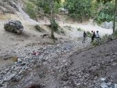
The large cobbles in the creekbed, and lack of vegetation or lichens, show that the stream moves a tremendous amount of sediment downstream during runoff events. A delta of cobbles and boulders exists in river below.  


Agreed. Although from google maps it looks like there isn't an obvious tract of exposed soil in the water catchment to erode rapidly.


Not that I was looking for it, but I don't recall seeing lichens anywhere in my travels there.  I know they exist in Haiti because of the videos by CrimePaysButBotanyDoesnt on YT.  I think they tend to exist at higher elevations in the pine forests; above 2,000ft.

Yes there are many cobbles.  That huge fractured boulder has been there many years.  It might be hard to tell in the photos/video but in person I could see it has has a concrete stand/tuck-pointed to keep it from rolling down the hill.  

I think most of those cobble stones are not the result of water gushing down that mountain road.  I think some are (1) already present in the strata and become exposed as the water carries away smaller sized sediment, and (2) fall from the adjacent inclines--perpendicular to the stream bed.  If you look at the photo of the site looking downhill where you see the guy with the crutches, note how on the right side of the gully there is black/dark brown "top soil" complete with the wavy line of the last high water mark.  But on the other side with the road, there is none.    

Yes, Google Earth Pro (on a computer as a stand alone program with the imagery timeline feature) is great--among other tools and maps.  Just to clarify, I'm not relying of google earth.  I personally visited the site.  Yes, I agree. within the immediate drainage channel, there is not an abundance of loose matter.  
2 years ago
I am curious if there are any other Americans/ English speakers here who are setting up homesteads in Haiti.  I know it sounds like an odd place to build a homestead but it does have some "pros" that some people may find attractive.  All my points below are only in reference to the Grand Sud ("Sud" means "South" in Creole) i.e. Most of the the violence you see on the news is in the capitol Port-au-Prince in the the center of the country.  The Grand Sud refers to the three Departments of Grand Anse, Nippes, and Sud.  

Haiti has 10 Departments like the USA has 50 States.  Similar to the U.S. Constitution, the Haitian Constitution allows the Departments to operate with certain semi-autonomous capacities/authorities.  During my couple of recent trips to the Grand Anse I've met a few Americans with homesteads there.  On my last trip, I met a man, formerly of the Amish tradition, who has spent the last several years building his homestead along the banks of the Voldrogue river.

Some Pros:

(1) it has the cheapest land in the Caribbean (which I admit has many issues in terms of legal titles...but you can still purchase/lease to own land from the government for about $5,000-$6,000/karo (3.18acres)).  The geography and climate make Haiti one of the types of places "permies" seek out for homesteads.  FYI, The elevation in Grand Sud ranges from sea level to 6,800ft (Pic Macaya).

(2) Legally, from what I understand, there are no property taxes levied on vacant land--only "built structures."  And in the poor but peaceful rural "Grand Sud" (the far southwest part of Haiti), property tax enforcement is weak).

(3) There are no enforced building codes or zoning laws.  If you want to build a structure right up to your property line, no government official is going to stop you.

(4) The waters are free from chemical pollutants, pesticides, herbicides, and chemical fertilizers because there is no heavy industry and no one can afford those agricultural products.

(5) Abundant fresh water and hydro-power potential with none of the permitting red-tape.  There is of course local political dynamics but it would not be with the central or state government--just working it out with your adjacent land owners.

(6) Extremely cheap labor.  The idea of hiring 20 young men for a farm project for two days will only cost you about $200 (20 men * $5/day * 2)

(7) American humans cannot legally own land in Haiti but American non-human entities can own land in Haiti.  So if you set up an LLC or Corporation, that entity can legally own land in Haiti.  

Some Cons:

(1) Emergency medical treatment.  If you can pay the modest fees (e.g. $15-$20 to see a medical doctor, $10 for a saline drip, $80 dollars for an x-ray and an arm cast), basic medical treatment is available.  But there are no rapid response teams/ "911" for severe trauma, heart attacks, etcetera in the Grand Anse.  

(2) It's a two day process to get to/from USA and the Grand Anse.  There are daily flights from USA to Port-au-Prince and Cap-Haitien but to get to the Grand Anse, you then need to take a flight with Sunrise Air from one of those two cities to Jeremie (the capital of Grand Anse).

(3) general unreliability of staple goods like gasoline.  When good gasoline/diesel is available at the pumps, stock up.  Outside of Jeremie, there are no supermarkets--which means, unless you butcher your own animals, fresh meat is only readily available one day a week--"market day."  

(4) there is no 24/7 electricity in ~98% of the Grand Anse by land area.  You must operate your own off-grid power system.

It would be interesting to see a wave of Americans moving to the Haitian frontier that is the Grand Anse. Having met a couple Americans living there on homesteads, I was curious if there are anymore who may be present here?  Or perhaps anyone interested in checking it out?  

Below is a photo of me in the Ravine-a-Charles across the Grand Anse river from Marfranc--which is one of the top locations I've scouted for the lowest cost per kW hydro-electric plant site.  No dam needed at this site to yield ~200kW continuous output!    

2 years ago
Thanks for the link.  Although I'm familiar with the concept, no, that is not the plan here. There is little to no open sand deposits above the dam to flow into it.  Perhaps you are thinking about my reference to sand bags behind the dam.  But this is just to temporarily divert the flow during construction.  Such a design, a low head sand dam, may work on the main river Grand Anse which our stream flows into since the river grand anse has substantial sand deposits.

One thing I've noted is that the road above the dam site is pitched away from the gully and did not appear to have erosion issues.  You can see this in the images I've posted of the site.  I added two more photo below of the exact spot where people currently gather water from this site to provide a little more context.
2 years ago

Joseph Lofthouse wrote:An intake system located completely underground does not require maintenance.


Yes this is an interesting concept if you mean, rather than build the dam I propose, we build a "spring box" type structure.  I'll give this some thought.  I've actually seen two examples of massive concrete spring boxes in Haiti.  Picture the dam I'm proposing but if it was covered with a flat roof that seals to the edges of the gully.  This way when the deluges come, the water just flows over spring box.

The issue with doing this is the expense and the risk that the "spring" goes dry--in which case that ~$30k spring box is useless.  Where as even if this spring goes dry (which I'm told by a local man who has walked past it twice a day for 50 years--he has never seen it stop flowing), the dam will still help slow the flow of water to the Grand Anse river and ideally, help recharge lateral/adjacent springs.

One last note, a local "plumber" who was very knowledgeable about the local hydrology (and will oversee the workers digging the footing trench) insisted that the dam's footing be 4ft deep for a 2-3' crest height.  I tend to agree and will update my design accordingly.  I was concerned about being able to dig that deep in the hard limestone ground but he and others insist it will be fine.  Labor is very cheap.  We plan to pay workers $0.50/hour + catered lunches prepared by local chiefs.  Keep in mind this entire construction project will be done with hand tools and a cordless drill.
2 years ago
A couple other comments:

In re earthquakes, an apparent solution to this issue in Haiti has been for civil engineers to build large concrete monoliths.  a big reason you hear about so many houses in Haiti collapsing during earthquakes is because they are built with weak cinder blocks and use bad methods, e.g. they don't interlock the blocks at corners and simply abut the walls.  Picture a square house where they form the four corner columns with rebar and forms and then build block walls between the four posts.  It's just waiting to fall apart.    

Below is a photo of a new earthquake proof house being built by a civil engineer.  Note the 12" thick foundation slab monolith.  And with the bamboo structure set into it.  Such that during an earthquake, the slab may move but stay intact and the bamboo can flex and move with the vibrations.

It is the major hurricane or even the regular May and October rain events (see weather chart below) that I'm concerned with.  i.e. that the dam will over-crest.  But per Joseph's suggestion, I will increase the "skirt" to a full apron the full length of the dam.

In terms of a "piping" failure, i.e. where water flows under the dam slowly eroding it, there is already a natural "pipe" in that there is a another exit point/ "spring" 100ft from the dam down the hill.  See photo below.
2 years ago

Joseph Lofthouse wrote:We understand how to pour concrete underwater. Lots of online resources and tutorials exist.  You might also place an over-sized diversion pipe under the structure, to drain water away while under construction. Then plug it later.

Yes, as of now the plan is to first build a sand bag weir behind the dam with a 4in drain pipe that will run through the dam wall.  If we need to remove more water, I reckon we will set up 1-2" pvc siphon pipes over the wall site as needed.  then when the pour is complete, turn off the ball valve on outside of dam wall.

Do you intend to collect the water uphill of the dam, through the underground gravel deposits?

No. Simply create a tall enough pool to act as a "settling tank" and to elevate the intake box/pipe above the ground.  This little nook is the highest point in the valley where this disappearing stream still emerges.  This region of south west Haiti (Department Grand Anse) is know for hyrdological anomalies, e.g. a fresh water spring is next to a salt water spring, a 98F degree hot sulfur spring is 100 yards from a dozen 66F degree cold springs.  The temp of the water coming out at our site was a consistent 76.4F degrees--which leads me to believe it is coming from surface water higher up in elevation and reemerging from this site.

Flash floods can easily overwhelm structures. I wonder if the whole structure needs an apron? Everything uphill of the dam will fill with gravel during the first major run-off event.


Yes I like this idea.  I can also open up the cross sectional area of the spillover area by 4-8ft2.  One thing going for us is that it will be keyed 4 feet on either side into the mid-hard limestone.  I'm not too concerned about rocks and boulders flowing down the road.  But yes sediment in general will be an issue requiring maintenance.  Due to the lack of forest cover on the mountains, top soil and dirt turns the waterways brown.  Charcoal is the biggest industry in this region.  Most people earn $300-350/year.  Police are paid $10/day.  This area, the Grand Anse river valley is home to one of the last American Eel spawning watersheds.  Just a couple years ago peasants upstream would catch and cook 4ft monsters.  But now with the Chinese glass eel dealers, everyone and their brother is out there near the mouth of the river scooping up the babies.  :(
2 years ago