• Post Reply Bookmark Topic Watch Topic
  • New Topic
permaculture forums growies critters building homesteading energy monies kitchen purity ungarbage community wilderness fiber arts art permaculture artisans regional education skip experiences global resources cider press projects digital market permies.com pie forums private forums all forums
this forum made possible by our volunteer staff, including ...
master stewards:
  • Carla Burke
  • Nancy Reading
  • John F Dean
  • r ranson
  • Jay Angler
  • paul wheaton
stewards:
  • Pearl Sutton
  • Leigh Tate
  • Devaka Cooray
master gardeners:
  • Christopher Weeks
  • Timothy Norton
gardeners:
  • thomas rubino
  • Matt McSpadden
  • Jeremy VanGelder

Does anybody really know what Keyline is?

 
Posts: 19
Location: Southern California
  • Likes 1
  • Mark post as helpful
  • send pies
    Number of slices to send:
    Optional 'thank-you' note:
  • Quote
  • Report post to moderator

Frankly, I’m tired of not being 100% confident in understanding Keyline Design.

Let me run through what I think I already know about it:
- The main ridge line usually descends in elevation so that every primary ridge and primary valley shooting off from it is lower than the next

- Each of these primary valleys has a key point located within it and the different key points from valley to valley are in different spots

- The key point is not the point of inflection where a slope goes from convex to concave, but rather is located just below this inflection point

- The key point is the highest point water will fill up to in a valley if that valley is dammed

- From the key point you draw a contour line and this becomes your key line

- Every equidistant line you use for plowing, swales, tree belts, crop beds etc. above and below the key contour line runs parallel to the key contour line

- Running parallel to the key line will ensure that both your parallel lines above and below the key contour line will slope gradually off contour and carry water runoff from the higher valley points to the lower ridge points which would other wise have water rush off them into the lower parts of the valley

- The slightly off contour parallel lines should be gradual at 1:100 or even 1:300 rise over run

Is there anything wrong with my understanding of it? What critical points am I missing? Because if I was to go out and design a key line property today I don’t think I could do a perfect job.

Here are some of my questions:
1. Besides being a marker for ideal dam placement, is a key point even necessary to locate or even have inside a valley? In other words, how much wiggle room is there to base your parallel lines off of a line other than the precise key point?

2. Why can’t you just choose any place to start your lines, parallel pattern from there, and make sure that the lines will slope down towards the lower ridge tops with a 1/300-1/100 grade?

3. When it comes to evenly distributing water to both the ridges and valleys, doesn’t a contour swale cutting through the valley and ridges perform the same function? Is this primarily driven by convenience?

4. Besides being reliably spaced for machinery, what advantages do tree belts on a keyline pattern have over other orchard planting patterns?
 
author & steward
Posts: 7159
Location: Cache Valley, zone 4b, Irrigated, 9" rain in badlands.
3350
  • Mark post as helpful
  • send pies
    Number of slices to send:
    Optional 'thank-you' note:
  • Quote
  • Report post to moderator

To me, out in the desert on steep slopes, the keyline is all about water velocity and sediment load... Above the keyline, the water is moving too fast to contain. Even if I do manage to temporarily slow the velocity, the sediment load is too much to handle... At the keyline, the water velocity and sediment load become manageable.

 
pollinator
Posts: 814
Location: Central Virginia USA
78
  • Mark post as helpful
  • send pies
    Number of slices to send:
    Optional 'thank-you' note:
  • Quote
  • Report post to moderator
The safe thing here would be to let Daren  respond, but  here is my addition to the discussion and I certainly welcome corrections

Your observations/ summary seem basically correct. I'm a beginner also, and as I walk back and forth doing my hrs of observation I think I finally understood what PA meant when he had that revelation and saw how simple and elegant the whole thing was.

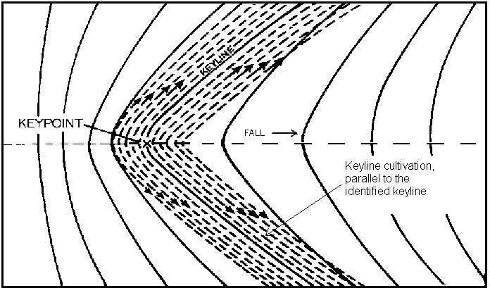
In my mind, I use the stated formula for locating a keyline dam as a general explanation, but on the ground, especially when trying to locate dams as high as possible, those high dams will likely be above the formulaic key line, and the things to consider are many when determining spacing etc.

The main reason for the keypoint is to determine the best place to obtain the material for the dam wall.if the Valley continues to slope away from the proposed water level ,  you have less and less material but more needed to fill in the deeper area at the wall, so prospects of getting enough clay for a dam wall diminish as the slope from the (proposed)water level increases.

Going from convex (hump) to concave (indented) in my experience is often not straightforward as if there was a specific point that would determine the final water level. Looking at the overall--how steep is the convex, how shallow is the concave, or if there is no well defined point, find the flattest part of the gully floor. Think about looking at the gully contour sideways, the concave part of the gully even looks like a small natural pond

I have also done a bit of digging/ dam building on my own property and there is also the nature of the material down in the valley and especially at those key points. As water rushes down and hits those flatter areas it will tend to slow and stuff will settle out--primarily the clay, which of course is just what you want

The idea of the key point may also connect geologically to earth strata laid down in layers over time, and without dramatic upheaval in the landscape there can often be observed the colocation of key points where going around the ridge on contour and into the next valley will find you at another keypoint in the new valley. Or at least close enought to make the connection between dams

This is all theory, but helps me tie together some of the observations of Geoff and PA that I've heard.

PA's idea of plowing downhill to the ridge likely originated as part of a broad acre design to promote instant irrigation just by turning a valve at a dam--PA had this thing about fireproofing the landscape. For smaller spaces between tree belts on contour, I would think just direct contour plowing for most applications would be fine, and more efficient to maintain.

Swales and planting trees of course go together--it's a quick, no extra trouble needed way to supply water to the trees root zone encouraging the roots to go down.

If there was a reason why the straight level swale wasn't desired, net and pan would work,  but from now on I want to make sure when planting trees I get water under the tree root and not water from the surface. After a few years of doing it half assed, I start to understand the value of that extra consideration when planting. so Whether it's the natural deep watering of a swale,  a drip box at the bottom of the hole, or some way to funnel water underground naturally in the pan planting, watering deep is the way to go


So let's see about your questions

1.The key point (depending on the slope of the valley may not exist or be very poorly defined. My valley/gully is a case in point it slopes almost uniformly, no convex or concave too much, so at that point I look for other features (which might include other possible dam sites, so one of my points includes a contour dam which has a nice fairly flat field out from the contour that connects to the main gully dam. As that goes around the ridge it naturally connects into another reasonably good site in the next Gully so it becomes an integrated system with water from both gullys available to that entire swale.

The swales coming off the dam are level, not the "downhill to the ridges" plowing method of keyline-- this might be altered to suit a specific design, but a level swale allows water to flow both ways, and if you want to direct water one way a few sandbags at one end or the other can do that

water does flow in a level swale, but in a rain event it is likely to fill first from runoff, then if there is excess flow  in the gully, the flow in the swale (from the dam overflow) will be more like a rising tide than an energetic erosive flow

2. The sloped grade for plowing is applicable in some cases, but in others contour/level lines are more appropriate, a lot depends on just how intensive the management will be and what other features are in play. Keyline is a great way to provide easy, quick water access to broad acre plantings and for hydrating ridgelines more evenly. But as a design evolves to include tree belts, those belts are built on swales designed around level contours (at least by geoff's methods)

3. already answered

4. again tree planting might be designed on a strict keyline method, but Geoff really doesn't teach to use that downhill gradient for swales, which is the most convenient way to deep water trees without pipes and special consideration. Keeping the compacted level part of the swale on contour allows water to flow from either end and when water moves down the slope it goes under the loose earth of the swale watering the deeper roots of the trees. If your irrigation only comes from one water source the slope of your keyline downhill slope would likely insure more water got out to the ridge  (but then would not go around it).

In fact, having water passively sitting in a swale line and soaking into the loose earth at the downhill side of the swale is really what a tree planting swale is all about. mostly the water is not supposed to run at all, it is just supposed to sit and soak

Remember , in Permaculture we use all the tools, keyline is a tool, not an absolute. become familiar with how water behaves, get real knowledgeable and think your design through over and over, do a couple small tests and think it through again ,, don't get hung up on keyline, although understanding the how and why of keyline is a very useful tool to have.
 
Posts: 100
  • Likes 3
  • Mark post as helpful
  • send pies
    Number of slices to send:
    Optional 'thank-you' note:
  • Quote
  • Report post to moderator
TO:  C. Sanct
FROM:  Eric Koperek = erickoperek@gmail.com
SUBJECT:  Keyline Watershed Management
DATE:  PM 2:55 Sunday 21 August 2016
TEXT:

(1)  Forget about keylines.  Concentrate on contour lines.

(2)  Walk your land when in rains.  Watch where the water comes from and where it goes.  The harder it rains the more you will learn.  This is the KEY to watershed management.  Nothing can replace "boots on the ground".  Until you see water in action "book learning" will not do you much good.

(3)  Concentrate on one (1) watershed at a time.  Your property may have only 1 watershed, several, or many, depending on the lay of the land.  Don't overly complicate management by trying to do too much at once.  Watershed management requires years of patient observation and effort.

(4)  Keyline plowing is for flat areas and gentle slopes.  You don't need expensive equipment; you can make your own or have a welding shop make a "plow" for you.  

(5)  A Keyline "plow" is a specialized tillage instrument similar to a chisel plow or subsoiler.  (Original keyline plowing in Australia was done with common chisel plows).  All you need is a toolbar with 3/4 inch wide knives 12 to 16 inches long spaced 2 feet apart.  Very simple = not expensive.

(6)  Plow along CONTOUR lines once yearly for the first 5 years.  Thereafter, plow only as necessary to keep range land healthy.  Slits channel air and water into the subsoil stimulating underground micro-organisms and improving plant growth.

(7)  Wherever watershed is large enough, build a dam to retain water for flood irrigation of pastures at lower elevations.  Alternatively, you can build "tanks" = ponds with porous bottoms designed to trap and store water temporarily until it can soak into the ground and recharge aquifer.

(  On steeper slopes use a trenching machine to dig trenches along contour lines.  Sink trenches as deep as machinery allows.  Space trenches every 50 feet along slope contours.  You can also dig trenches on gentle slopes and flat areas to trap water for subsoil storage.

(9)  You can also erect small bunds = earth walls and narrow swales = shallow ditches along hillside contours to trap rain before it runs off slopes.  Trees planted in the swales will help stabilize slopes and increase water infiltration into subsoil for aquifer recharge.

(10)  I will provide more information later.

ERIC KOPEREK = erickoperek@gmail.com

end comment
 
Posts: 47
Location: Sunshine Coast, Queensland, Australia.
  • Mark post as helpful
  • send pies
    Number of slices to send:
    Optional 'thank-you' note:
  • Quote
  • Report post to moderator

This image shows you the keypoint in a keyline dam system:

[table]


It is taken from this page:

http://www.laceweb.org.au/Chapter%20Three.htm
 
eric koperek
Posts: 100
  • Likes 3
  • Mark post as helpful
  • send pies
    Number of slices to send:
    Optional 'thank-you' note:
  • Quote
  • Report post to moderator
TO:  C. Sanct, Chrissy Star, Joseph Lofthouse
FROM:  Eric Koperek = erickoperek@gmail.com
SUBJECT:  "Keypoints" in Keyline Watershed Management
DATE:  PM 7:42 Wednesday 31 August 2016
TEXT:

Please excuse my delay in responding to your questions; I have many clients and 90,000 acres of farmland to manage.  Consequently, my response time is often measured in days or even weeks.

(1)  Chrissy Star has posted a classic drawing of a "Keypoint".  Unfortunately, watersheds rarely conform to textbook drawings.  In practice, it is difficult to accurately locate a "keypoint" within several hundred feet of elevation in most real world circumstances.  DON'T WORRY ABOUT IT.

(2)  The concept rather than exactitude, is what is important.

(3)  Imagine a steep slope merging with a more gentle grade.  Where steep meets shallow is your "keypoint".  

(4)  Functionally, the "keypoint" is the first place where it is practical to build a dam as far up a watershed as possible.  Build the dam at higher elevation and you won't collect enough water (and engineering becomes painfully expensive).  Build the dam lower and you will need a larger structure (which increases costs).  Also:  The lower in elevation you build a dam, the less "head" you have to work with = water pressure is lower and the amount of land that can be irrigated by gravity is greatly reduced.  

(5)  Where to locate dams is both an art and science.  The best way to learn this is by walking your land.  A few quick calculations of area and rainfall will give you a good approximation of how much water you can collect from a slope (watershed) of known dimension.  Everything that follows is Tinkertoy engineering.

(6)  The primary concept of Keyline watershed management is to build small dams wherever practical to store water for flood irrigation of fields and pastures at lower elevation.  Many dams over an area of range land can significantly alter local micro-climate and dramatically increase forage production.

(7)  There are other ways to approach this problem.  You can build "tanks" = ponds with porous bottoms designed to recharge aquifers.  The idea is not to store surface water for any length of time but to get the water underground as quickly as possible.  This technology is thousands of years old and originates in India.  Read about Vedic agriculture.

(  Another solution is to dig trenches every 50 feet along contour lines.  Use a trenching machine and dig as deep as machinery allows.  Trenches intercept runoff and conduct water deep into subsoil for storage and aquifer recharge.  Again, the idea is to get the water underground as fast as possible to prevent significant evaporation losses.

(9)  You can employ similar tactics in wadis = arroyos = canyons = gullies = coulees = gullies = washes = any intermittent stream bed.  Build check dams = weirs every 50 to 100 yards approximately (according to slope and availability of rocks).  Dig trenches 1 to 2 feet wide and as deep as possible every 50 feet across stream beds.  Weirs slow water flow and trenches conduct water into subsoil for storage.  The idea is to trap every drop of water that flows into a wadi system.  Get the water underground as fast as possible.

(10)  Key Concept:  Agriculture in arid and semi-arid climates is all about managing UNDERGROUND WATER.  Replenish aquifers = raise water tables and crops, trees, and pastures will thrive.

(11)  Note:  Most canyons have underground streams close to the surface.  These under-surface waterways can flow 5 years between rains.  Underground streams allow trees to thrive in drought conditions.

(12)  Most Americans have never heard of "horizontal wells".  These are similar in concept to ancient "qanats" found in Persia and throughout the Middle East.  The modern interpretation is to bore a hole into a mountainside and let gravity deliver the water for you.  This largely eliminates the need for vertical wells and pumps.  Dig contour trenches on slopes at higher elevation and you can turn every hillside into a giant water collection system (much like a tent or a building roof).  Every inch of rain will yield about 2/3 gallon of water per square foot of relatively impermeable surface area (like steep, rocky slopes).  Capture this water with trenches = get it underground fast and your horizontal bores will run year-round without attention.  Let Nature and gravity do the work for you.

(13)  Contact me if you have any questions or require further assistance.

ERIC KOPEREK = erickoperek@gmail.com

end comment


Enjoy the full beauty of the english language. Embedded in this tiny ad:
Switching from electric heat to a rocket mass heater reduces your carbon footprint as much as parking 7 cars
http://woodheat.net
reply
    Bookmark Topic Watch Topic
  • New Topic