• Post Reply Bookmark Topic Watch Topic
  • New Topic
permaculture forums growies critters building homesteading energy monies kitchen purity ungarbage community wilderness fiber arts art permaculture artisans regional education skip experiences global resources cider press projects digital market permies.com pie forums private forums all forums
this forum made possible by our volunteer staff, including ...
master stewards:
  • Carla Burke
  • Nancy Reading
  • John F Dean
  • r ranson
  • Jay Angler
  • paul wheaton
stewards:
  • Pearl Sutton
  • Leigh Tate
  • Devaka Cooray
master gardeners:
  • Christopher Weeks
  • Timothy Norton
gardeners:
  • thomas rubino
  • Matt McSpadden
  • Jeremy VanGelder

Plant Hardiness Maps: U.K. & other countries

 
pollinator
Posts: 104
Location: St Leonards-on-Sea, UK (50.86°N; 58 metres a.s.l; 1.8 Km inland)
18
  • Likes 4
  • Mark post as helpful
  • send pies
    Number of slices to send:
    Optional 'thank-you' note:
  • Quote
  • Report post to moderator
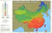
I came across a very useful link recently, that I hadn't seen before - I'm sure it will be useful to others here.  
The link provides a range of plant maps based on climatic zones (e.g. using the USDA plant-hardiness classification)  and dates for the last expected frost, etc.  You can zoom in to any of the maps to get more details for specific towns & cities.  It has maps for European countries, e.g. UK, Ireland, France, Iceland, Belgium, Netherlands, Norway and if you click on the Plant Maps tab it will open up some maps for North America.

https://www.plantmaps.com/interactive-united-kingdom-plant-hardiness-zone-map-celsius.php
 
I am Arthur, King of the Britons. And this is a tiny ad:
GAMCOD 2025: 200 square feet; Zero degrees F or colder; calories cheap and easy
https://permies.com/wiki/270034/GAMCOD-square-feet-degrees-colder
reply
    Bookmark Topic Watch Topic
  • New Topic