Thanks Aljaz and also for your kind words,
First of all thanks for having the sensibility to understand your site and look at using site-appropriate treatments rather than just applying carte blanche!
Secondly, I have an old colleague from my days working for Mars Inc. in Viet Nam who is Slovenian and she was always telling me how I must go there and how beautiful it is etc. We'd love to go to everywhere in the world and Slovenia is definitely on the list!
So straight to your questions:
Starting point — there is not much point using Keyline geometry if you don't have a good contour map to manage your design on first. So often there are landscape anomalies that require some advance desktop planning if you are going to do you and your system justice.
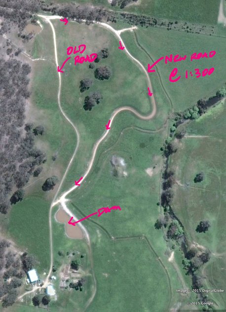
But yes the lowest ridge contour is often the best place to start and yes find the apex of that ridge and go from there.
Following is an instruction I gave on this question in our
Regrarians Facebook Group just the other day:
"...In the absence of a proper survey having been completed I would stake a series of contours over the site and paint-mark (or ribbon) the stakes different colours that alternate from one contour to the next (2 colours should do) so that you can differentiate between each marked contour.
Then start marking out the guideline offsets again using alternate colours (though different to the contour colours) and then compare these offsets to the contours. You're doing here what we'd normally do on the screen following a detailed contour map.
If the guideline offsets are going where you want them to then go back to the guideline and adjust it and try again (and again!!) until you're satisfied..."
Years ago i turned up at a clients property and his son had just done a Permaculture Design Course with a Prince and King (

). Anyways he was setting out a 0.25 hectare orchard following the contour as per the logic recommended at the PDC and had put stakes in the ground following the different contours and strung string between each stake — so he had marked contour lines effectively. It was diabolical from a land use and access perspective, no equidistance, some rows were 1m apart and some 10m apart such were the shape of the contours on this hillside.
So with this I grabbed a bundle of stakes and picked a lower contour and then put a stake in lower on the ridge curve and higher on the valley curves. Then I used the tape and went 90 degree and marked out a series of additional rows parallel to this lower line. Then I referenced these against the contour and we had to tweak the lowest line's shape in order to get the desired effect i.e. rows gravitating to always fall to the centre of a ridge. We even strung line between the Keyline pattern stakes just so the client's son could get the picture — which he did and shook his head for the logic and genius that is the
Geometry of Keyline.
I do hope that this all helps and please let me know if you have any further questions.
Cheers,
Darren