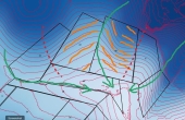
b wrote:currently i till up and downslope. There are ditches along the border between field 16 and 27 and 27 and 28. My idea is to do keyline tillage and perhaps keyline subsoiling to help more even distribution of water. With climate change the precipitation is becoming much more erratic....
I'm struggling a fair bit to determine the best keylines for tillage and subsoiling and cropping.
Thanks so much in advance!
Welcome to permies!
*steps onto soap box* Since tilling destroys soil structure and reduces organic matter content, it will increase runoff, thus the waterlogging along the lower areas of tilled fields especially. Every 1% OM content boosts water holding capacity of soil by about 0.47 gallons per square foot...wowzas. So conversely, destroying OM reduces that water holding capacity. So bonus points to you if you can adopt a gentler cultivation practice to alleviate runoff to begin with! *steps off soap box*.
Good thinking to work the contour instead of up and down slope!
Regarding keyline, I like Nancy's drawing. I drew one up myself, and I think I'd have a similar recommendation as hers. Imagine my lines are all parallel and equidistant.
I would choose the contour running through those northern notchy-crotches at the boundary between fields 16 and 27 and 27 and 28.
Disclaimer Note: I haven't read
Water for every farm, so this is just based on the knowledge I do have from my PDC and personal studies leading up to that. (My teachers left much to desire regarding keyline during the PDCs, to my chagrin.) It appears to my untrained eye that the inflection point between increasingly steep and shallowing contours happens up in those crotchy-notches. Using those as a starting contour "keyline" seems to draw water downhill to the ridges from valleys when the pattern is applied downhill along the presumed primary valley (green dash with the stars). Best wishes!