posted 5 years ago
Hi folks,
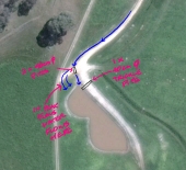
Looking for advice on keyline/master line design for a 80+ acres silvopasture operation, trying to come up with the right design. USDA Zone 3 in Canada, south-facing 2-7% slope. Being on top of a hill (red spot on the map is the highest point) makes me want to maximize water caption from rain and melting snow (approx 800mm rain + 250 mm snow annually).
I keep scratching my head as the primary valleys and primary ridges are definitely not clear to me on the contour map. Attached are the 50cm (1.5 feet) contour maps of our north and south fields, along with modelized color-coded elevation and theoretical water flow lines. The big red spot is what I consider to be the main ridge.
When trying to pinpoint primary valleys and ridges, and keypoints, I keep going back to the fact that the slope is fairly straight down without clear-cut ridges and valleys like I see on some of the keyline maps out there, and it makes for very short keylines whenever I try to put them up on the map. Should I revisit my thinking around keyline? Any suggestions as to how you would approach this property? I will of course experiment next spring with a contour tool in the field, but I want to have a general idea of my design on map before doing so.
One of the limiting factors that I'm facing is that the tree rows in between most fields are rock mounds (dating back from when the land was cleared) that would be very costly to remove/move, so I'm somewhat forced to plan tree crop rows on a per-field basis. I could move the dirt road that crosses the main field and place it according to the tree crop rows.
Anyhow, if someone has an idea, I'm open to everything. Also considering cross-contour planting + keyline subsoiling as I'm in a cold region, but that's for another thread!
Thanks,
Contour-50cm-North-fields-(Modelized).PNG
![[Thumbnail for Contour-50cm-North-fields-(Modelized).PNG]](/t/156562/a/133721/thumb-Contour-50cm-North-fields-(Modelized).PNG "Filename: Contour-50cm-North-fields-(Modelized).PNG
Description:")
Contour-50cm-South-fields-(Modelized).PNG
![[Thumbnail for Contour-50cm-South-fields-(Modelized).PNG]](/t/156562/a/133722/thumb-Contour-50cm-South-fields-(Modelized).PNG "Filename: Contour-50cm-South-fields-(Modelized).PNG
Description:")


![[Thumbnail for Contour-50cm-North-fields-(Modelized).PNG]](/t/156562/a/133721/Contour-50cm-North-fields-(Modelized).PNG "Filename: Contour-50cm-North-fields-(Modelized).PNG
Description:")
![[Thumbnail for Contour-50cm-South-fields-(Modelized).PNG]](/t/156562/a/133722/Contour-50cm-South-fields-(Modelized).PNG "Filename: Contour-50cm-South-fields-(Modelized).PNG
Description:")