posted 4 years ago
Hello everyone.
Just a quick question.
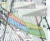
I am designing some swales on a piece of land that is 1 hectare (see attached photos). I just got hold of a contour map I am also attaching.
Obviously the swales have to be on contour but the slope runs from West to East and from North to South as you can see on the second photo.
So if I were to take an A frame and mark the swales as you can see on photo number 3, crossing the land from West to East with a spillway that will end on a pond on the eastern side...
The swales would still be efficient right? They will still infiltrate rain water and end in the spillway and the pond, correct? I would really appreciate all your inputs on this subject since I need to start moving earth pretty soon. Kind regards, Kike.
German-Contour-Map.jpeg
![[Thumbnail for German-Contour-Map.jpeg]](/t/182924/a/180412/thumb-German-Contour-Map.jpeg "Filename: German-Contour-Map.jpeg
Description:")
German-question-2.png
![[Thumbnail for German-question-2.png]](/t/182924/a/180413/thumb-German-question-2.png "Filename: German-question-2.png
Description:")
German-question3.jpeg
![[Thumbnail for German-question3.jpeg]](/t/182924/a/180414/thumb-German-question3.jpeg "Filename: German-question3.jpeg
Description:")


![[Thumbnail for German-Contour-Map.jpeg]](/t/182924/a/180412/German-Contour-Map.jpeg "Filename: German-Contour-Map.jpeg
Description:")
![[Thumbnail for German-question-2.png]](/t/182924/a/180413/German-question-2.png "Filename: German-question-2.png
Description:")
![[Thumbnail for German-question3.jpeg]](/t/182924/a/180414/German-question3.jpeg "Filename: German-question3.jpeg
Description:")