|

|
|
|
|

|

|

|

|

|


![[Thumbnail for IMG_20150411_150401.jpg]](/t/46020/a/27322/IMG_20150411_150401.jpg "Filename: IMG_20150411_150401.jpg
Description:")


Permaculture and Homestead Blogging on the Traditional Catholic Homestead in Idaho! Jump to popular topics here: Propagating Morels!, Continuous Brew Kombucha!, and The Perfect Homestead Cow!
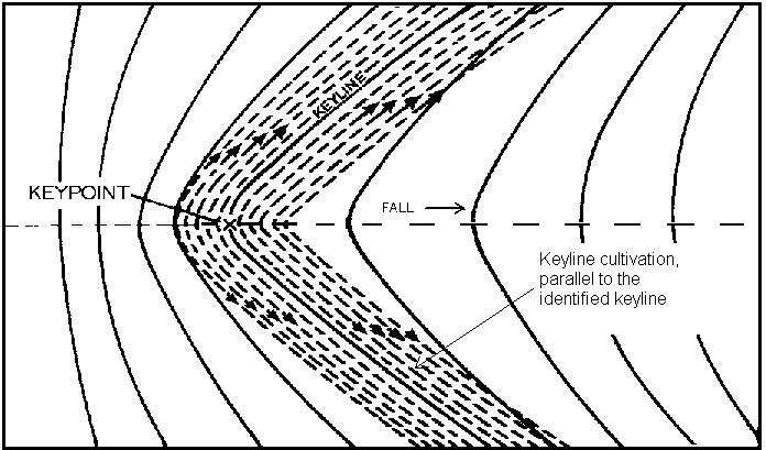
If you follow a contour line from a ridge to a valley it does not really go lower in elevation. If I dig a swale along the contour the water that fills that swale will fill it on a level untill it reaches a spillway that is designed to be lower than the rest of the swale. So if water runs down a valley and hits the "dam" of a swale it will fill the swale and move along the same elevation out to the ridge.
and againCultivate parallel and upward from any selected contour line on the ridges. When there is no Keyline to work from (lower in the valleys, or on ridges) use contour guidelines to cultivate parallel to (upward from on ridges, downward from in valleys.)
In practice, one would lay out the Keyline across the primary valley, then carry that contour line out onto and around both ridges, then cultivate upward from that in long plough passes. You would then plough downward from that line,restricting yourself to the valley shape. (The ridges would be ploughed parallel and upward from a lower contour guideline.

| I agree. Here's the link: http://stoves2.com |