• Post Reply Bookmark Topic Watch Topic
  • New Topic
permaculture forums growies critters building homesteading energy monies kitchen purity ungarbage community wilderness fiber arts art permaculture artisans regional education skip experiences global resources cider press projects digital market permies.com pie forums private forums all forums
this forum made possible by our volunteer staff, including ...
master stewards:
  • Nancy Reading
  • Carla Burke
  • r ranson
  • John F Dean
  • paul wheaton
  • Pearl Sutton
stewards:
  • Jay Angler
  • Liv Smith
  • Leigh Tate
master gardeners:
  • Christopher Weeks
  • Timothy Norton
gardeners:
  • thomas rubino
  • Jeremy VanGelder
  • Maieshe Ljin

Very basics about keylines

 
pollinator
Posts: 1981
Location: La Palma (Canary island) Zone 11
9
purity forest garden tiny house wofati bike solar
  • Mark post as helpful
  • send pies
    Number of slices to send:
    Optional 'thank-you' note:
  • Quote
  • Report post to moderator
I would not even imagine taking a course without having in mind the very basic...
I have taken wikipedia words...

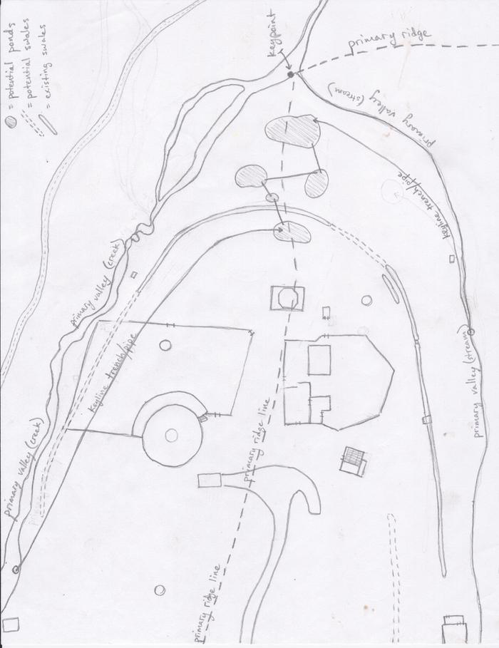
In a smooth grassy valley, a location called the Keypoint can be found where the lower and flatter portion of a primary valley floor suddenly steepens.


What means "primary" in that case?
Ok, this point is the lowest point of this flatter part of the valley...
But a valley goes to the sea, so are there several key points?
Do I guess right you find ones each time there is a flatter part?
Can we also say that this is the wettest part of the valley?
And hope you own the keypoint....
 
Xisca Nicolas
pollinator
Posts: 1981
Location: La Palma (Canary island) Zone 11
9
purity forest garden tiny house wofati bike solar
  • Mark post as helpful
  • send pies
    Number of slices to send:
    Optional 'thank-you' note:
  • Quote
  • Report post to moderator
Going on with wiki...

The Keyline of this primary valley is revealed by pegging a contour line through the keypoint, within the valley shape.
All the points on the line are at the same elevation as the keypoint.


Contours are, I think, those well known lines on maps, indicating altitude.
All the points on contour lines have the same elevation, right?
And same for the keyline then...

Contour plowing parallel to the Keyline, both above and below will automatically become "off-contour" but the developing pattern will tend to drift rainwater runoff away from the valley centre and incidentally, prevent erosion.


Contours on maps are never parallel.
The tighter the steeper.
So ok, the plowing is off-contour.

Now, in what sense is "parallel" on the ground?
How can you do this, do you need to imagine a "view from above", as in a map?
Is it more difficult to do it than seeing it on the map?

And how can you plow below the keyline, if this line is the lowest part of the valley?
I understand only plowing above.
And that plowing below will affect the next keypoint (by being above it...), at a lower altitude in the valley.
 
Xisca Nicolas
pollinator
Posts: 1981
Location: La Palma (Canary island) Zone 11
9
purity forest garden tiny house wofati bike solar
  • Mark post as helpful
  • send pies
    Number of slices to send:
    Optional 'thank-you' note:
  • Quote
  • Report post to moderator

Keyline pattern cultivation on ridge shapes is done parallel to any suitable contour but only working on the upper side of the contour guide line.
This automatically develops a pattern of off-contour cultivation in which all the rip marks left in the soil will slope down towards the centre of the ridge shape.


Here comes what is making me feel bad while reading and reading again....
I understand nothing of the first sentence.
What is a suitable contour?
This of the upper side is not clear either...

How do you join your plowing of the valley and the plowing of the ridge?
Are they 2 separate things? I cannot believe it...
Where do you stop the keyline drawing (that is supposed to take place only in the valley)
when you direct yourself towards the ridge?

what I do understand, I hope, is the effect of the plowing:
water goes to the center of the ridge shape instead of going down straight to the keypoint...
Better repartition of the water, that will go down more slowly.

This gives the false idea that "water goes up".
It goes down, as Newton makes us know, but it goes to the ridge by following the plowing.
 
Instructor
Posts: 44
Location: Eppalock, Victoria, Australia
3
  • Likes 2
  • Mark post as helpful
  • send pies
    Number of slices to send:
    Optional 'thank-you' note:
  • Quote
  • Report post to moderator
G'day Xisca,

Have you watched the Keyline videos at all? I'd especially suggest the best one to watch is from 1955 that we posted on Vimeo a couple of years agohttps://vimeo.com/13323213 . This does a fantastic job of explaining many of the key concepts around Keyline Pattern Cultivation.

Otherwise I can highly recommend to you the book by J. MacDonald Holmes 'The Geographic Basis of Keyline'

Thirdly in the thread 'Ridge Patterns' I pointed out the following:

"1. In valleys you should plow parallel below a contour
2. On ridges you should plow parallel above a contour
3. Where you are plowing from valley to ridge or vice versa and you want to do it optimally then you should A. mark the keypoint and then the keyline of the valley (its full and correct term) B. on the adjacent ridges mark the lowest point on the ridge and then the contours of these till you hit the valley C. Mark a parallel offset up the ridge (s) until you hit the end point (s) of the keyline of the valley D. Plow parallel to this continuous line both above and below and all is good in the world! "

That pretty well sums it up. Again this is why I have started to do eHD so that we can go through these very basic concepts at a pace that allows all to understand things from the start. I'm sorry Xisca that I've not been able to help you completely over the last week, but sometimes forums are not the best means of communicating things without spending more time that I unfortunately have available: that's why I don't do fourms anymore...

Thanks and all the best,

Darren
 
Xisca Nicolas
pollinator
Posts: 1981
Location: La Palma (Canary island) Zone 11
9
purity forest garden tiny house wofati bike solar
  • Mark post as helpful
  • send pies
    Number of slices to send:
    Optional 'thank-you' note:
  • Quote
  • Report post to moderator
Darren, thanks. I guess that you would have corrected any stupid statement when I interpreted the text.
Sorry, I read the thread 'Ridge Patterns' but could not understand it.

I have found a good link for beginners:
http://keyline.com.au/liqasset.htm

Then I have finally understood this better, helped by the diagram from the above link (well actually, it was the only thing I had already understood: the water "seems to go upward" when it goes down, but up the ridge...)


Xisca Nicolas wrote:Contours on maps are never parallel.
The tighter the steeper.


and the keepoint is where contours stop being very close one to the other. The land is flatter.

So ok, the plowing is off-contour.

Now, in what sense is "parallel" on the ground?
How can you do this, do you need to imagine a "view from above", as in a map?


So yes, they are parallel on the map....

Is it more difficult to do it than seeing it on the map?


Land is not paper!!!
How on earth can you measure the keyline right?
And how can you do this parallel as viewed from above?
It is much easier, I think, to stay on contours! (and you do not want to stay on contour, you want to direct water down, so that it goes to the ridge)
Parallel on the paper is NOT PARALLEL on the ground, isn't it?

WHAT TOOL IS NEEDED TO MEASURE ALTITUDE AND BE SURE TO STAY RIGHT ??
 
Xisca Nicolas
pollinator
Posts: 1981
Location: La Palma (Canary island) Zone 11
9
purity forest garden tiny house wofati bike solar
  • Mark post as helpful
  • send pies
    Number of slices to send:
    Optional 'thank-you' note:
  • Quote
  • Report post to moderator
The ridge:

"On ridge shapes, cultivation of the area below the channel is not be done parallel to the irrigation channel but parallel upwards from a lower guide line."

This illustrates well what Darren was stating:
"2. On ridges you should plow parallel above a contour"

What I miss now are 2 things:

- How do you chose this ridge contour?
The valley contour is the keyline... and what's about here on the ridge?

- The change of pattern line...
I cannot see how you can make furrows that stop and to not match!!!?
How do you connect the ones from the valley and the ones from the ridge?
 
pollinator
Posts: 4024
Location: Kansas Zone 6a
284
  • Mark post as helpful
  • send pies
    Number of slices to send:
    Optional 'thank-you' note:
  • Quote
  • Report post to moderator
This video made it "click" for me


Xisca Nicolas
pollinator
Posts: 1981
Location: La Palma (Canary island) Zone 11
9
purity forest garden tiny house wofati bike solar
  • Mark post as helpful
  • send pies
    Number of slices to send:
    Optional 'thank-you' note:
  • Quote
  • Report post to moderator
Sorry but the sound is too bad for me!
And he speaks about parts of the land, showing with hands without the camera showing anything.

I could understand the aim to distribute water more evenly and the way to go down slightly towards the dryer parts.
But, with your words - I do not ask a transcription of the video - on what did it make a click exactly?
 
R Scott
pollinator
Posts: 4024
Location: Kansas Zone 6a
284
  • Mark post as helpful
  • send pies
    Number of slices to send:
    Optional 'thank-you' note:
  • Quote
  • Report post to moderator
I guess maybe it is because I grew up on a farm, but once he described the "seat of the pants" feel I knew what he meant. That and herringbone.

Now I think of it as a mix of farming and plumbing. You are running your lines at a proper drain slope from the wet keypoint out to where it is needed.
 
pollinator
Posts: 3847
Location: Marmora, Ontario
593
4
hugelkultur dog forest garden fungi trees rabbit urban wofati cooking bee homestead
  • Mark post as helpful
  • send pies
    Number of slices to send:
    Optional 'thank-you' note:
  • Quote
  • Report post to moderator
Would it make sense to use a laser plumb line (I think that's what it's called), that landscaping tool that hangs on a tripod, marking a specific level 360 degrees with a laser line? You could, theoretically, anyways, have a laser-guided electric tractor tricked out for keyline plowing and, say, seeding simply following it.

-CK
 
Xisca Nicolas
pollinator
Posts: 1981
Location: La Palma (Canary island) Zone 11
9
purity forest garden tiny house wofati bike solar
  • Mark post as helpful
  • send pies
    Number of slices to send:
    Optional 'thank-you' note:
  • Quote
  • Report post to moderator
Mix of farming and pluming is a good image!
Then in the understanding, I wanted to go further after the theory, how you do it on the ground, and how you adapt to particular cases.

Level with a A-frame:
http://c.ymcdn.com/sites/www.echocommunity.org/resource/collection/C01889C5-4BB2-424C-962F-F5B14EF26E69/A-Frame_Level_%5boffice_format%5d.pdf
They explain the uses and how to do it.

A laser is sure good!
And a water level (little transparent pipe)
I think it depends the size of the land...
 
Posts: 17
2
  • Mark post as helpful
  • send pies
    Number of slices to send:
    Optional 'thank-you' note:
  • Quote
  • Report post to moderator
I'm digging up an old thread, but  wanted to reply to Xisca who never, I think, got a satisfactory reply except "use this tool" (A-frame? I guess so...)

The topo map makes it pretty clear what is meant by "parallel on map but not parallel on the ground". Everyone knows you're supposed to go parallel to that contour but...

The truth is each ridge-valley area will work slightly differently but everything is given on the map...

Just imagine you are hiking and you are following the line you drew on the map. If you cross lines going tight but getting looser (wider spaces), you're going from steep to flat... tight and getting tighter would be a steep drop off, etc.. the slopes generally run perpendicular to contour lines where the contour lines are "roughly" parallel... Valley or stream "notches" look just like that, little v-shapes, at least in mountainous areas... a valley is a gentle inverted-v-shape or notch... A ridge is also a v-shape, but the v points away from the peak...

To read it you need a single line you are following (the hiking line, the plowing line). In the map that was posted with the plowing patterns just follow any of those red lines to see what I mean.

On a contour map you will generally see the pattern valley-ridge-valley-ridge forming 360 degrees total around a given chain of hills or peaks.

In the pic above, which I assume is a typical keyline case, and certainly looks like a nice even valley formation like a "hollow", you can see our line of "hiking" is going down hill (crossing countour lines high to low). But we are not going straight down any slope, we are crossing a slope on a diagonal line made by flattening a line above or below the contour line. This line is not perfectly flat it is "diagonal down to the ridge".

It "stops" (meets with the same line form the adjacent valley) at some point right on that ridge line (the line connecting the v-points on the ridge). This is the same technique you use to predict how much uphill hiking you have to do on a given backcountry route through mountains.

Obviously the topo mao would be a rough guide to the real work of finding that spot on the land, in person. Further discussion warranted
 
I can't beleive you just said that. Now I need to calm down with this tiny ad:
GAMCOD 2025: 200 square feet; Zero degrees F or colder; calories cheap and easy
https://permies.com/wiki/270034/GAMCOD-square-feet-degrees-colder
reply
    Bookmark Topic Watch Topic
  • New Topic