• Post Reply Bookmark Topic Watch Topic
  • New Topic
permaculture forums growies critters building homesteading energy monies kitchen purity ungarbage community wilderness fiber arts art permaculture artisans regional education skip experiences global resources cider press projects digital market permies.com pie forums private forums all forums
this forum made possible by our volunteer staff, including ...
master stewards:
  • Nancy Reading
  • Carla Burke
  • r ranson
  • John F Dean
  • paul wheaton
  • Pearl Sutton
stewards:
  • Jay Angler
  • Liv Smith
  • Leigh Tate
master gardeners:
  • Christopher Weeks
  • Timothy Norton
gardeners:
  • thomas rubino
  • Jeremy VanGelder
  • Maieshe Ljin

Permaculture in the high desert of California

 
Posts: 42
Location: Llano, Ca
7
  • Mark post as helpful
  • send pies
    Number of slices to send:
    Optional 'thank-you' note:
  • Quote
  • Report post to moderator
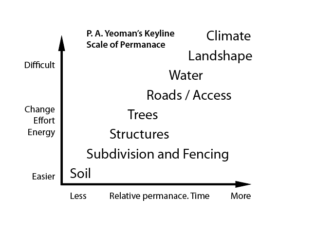
Having already chosen the climate, the high desert of California!


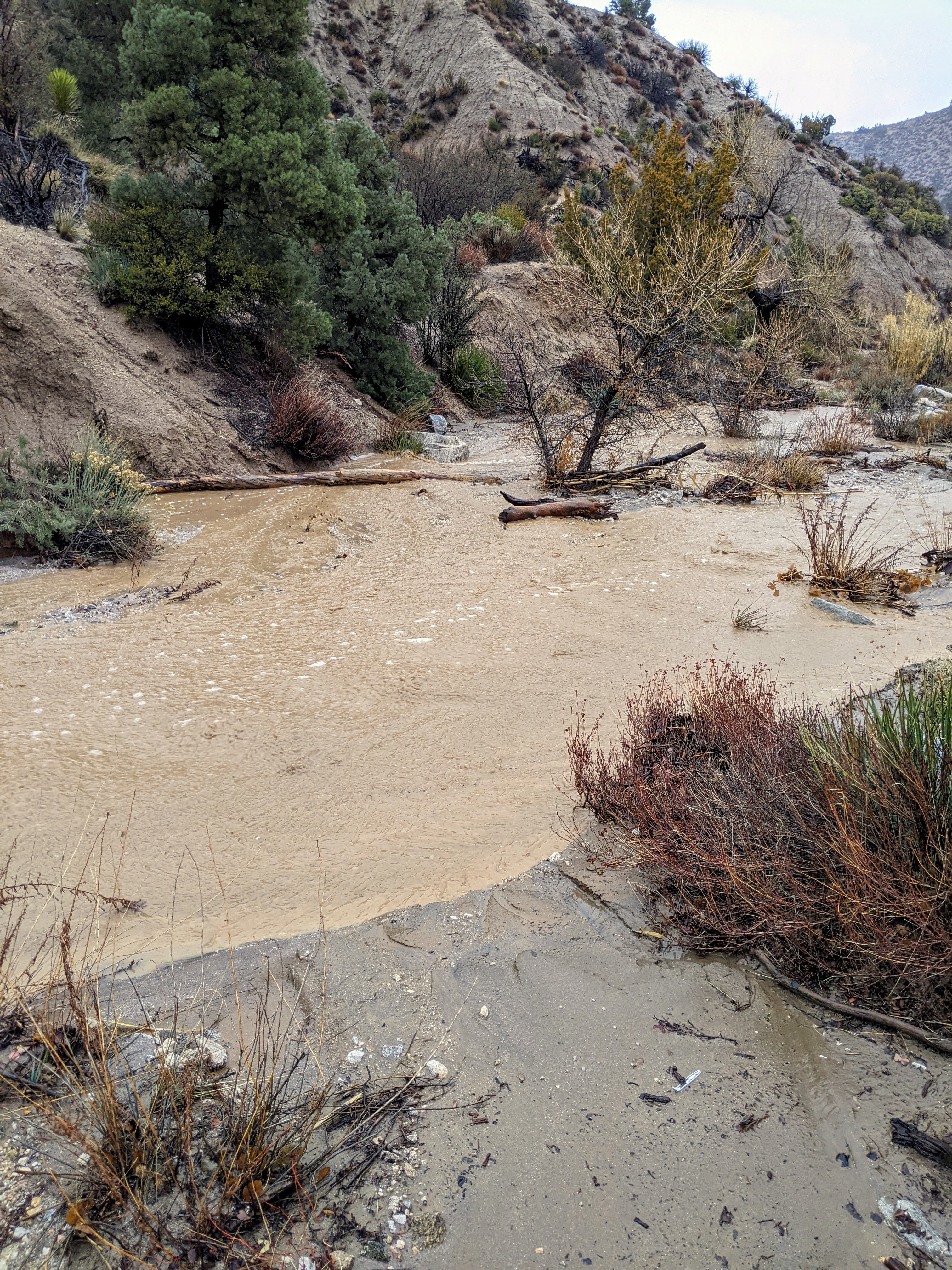
It's time to press into shaping the land. With the recent rains I was pleasantly surprised how it was possible to work with nature to move and manipulate the moving clay, sand and rocks when the rain does come.
 
Eric Lyle
Posts: 42
Location: Llano, Ca
7
  • Likes 2
  • Mark post as helpful
  • send pies
    Number of slices to send:
    Optional 'thank-you' note:
  • Quote
  • Report post to moderator
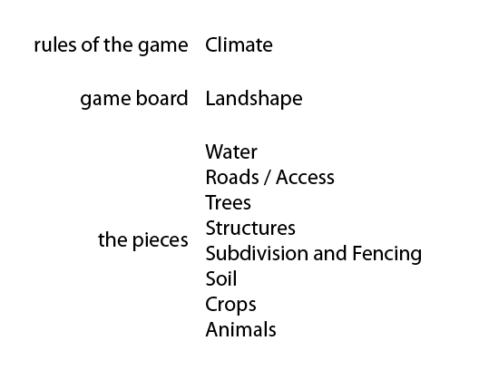
The ideas in these images are not my own, if you are familiar with permaculture you know where they are lifted from. I cleaned them up and made the information super clear. Feel free to use them.

Now that the weather is warming, would you like to come help and learn in the process? Here is a simple rustic wilderness in a canyon that is a beautiful watershed.

 
Eric Lyle
Posts: 42
Location: Llano, Ca
7
  • Likes 4
  • Mark post as helpful
  • send pies
    Number of slices to send:
    Optional 'thank-you' note:
  • Quote
  • Report post to moderator
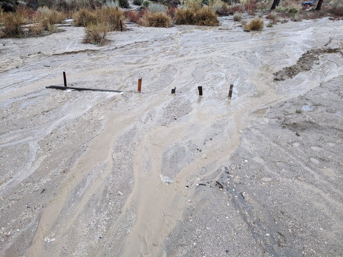
What a surprise when the rain fell. Of course there is a stream bed and a dry one at that. I could not believe so much water came from such a small water shed.

 
Posts: 152
Location: Southern Colorado, 6300', zone 6a, 16" precipitation
33
  • Likes 4
  • Mark post as helpful
  • send pies
    Number of slices to send:
    Optional 'thank-you' note:
  • Quote
  • Report post to moderator
Awesome picture. So what are you planning to do with that arroyo? What was the rainfall amount and what's the size of the water shed? Also, I read that Llano, CA has 7 inches of annual precipitation. Is that right? Then what are your plans or enterprises?
 
Eric Lyle
Posts: 42
Location: Llano, Ca
7
  • Likes 2
  • Mark post as helpful
  • send pies
    Number of slices to send:
    Optional 'thank-you' note:
  • Quote
  • Report post to moderator

Skyler Weber wrote:Awesome picture. So what are you planning to do with that arroyo? What was the rainfall amount and what's the size of the water shed? Also, I read that Llano, CA has 7 inches of annual precipitation. Is that right? Then what are your plans or enterprises?


First and foremost it is a refuge of tranquility for our family. I am also interested in the size of the watershed, I need to find a way to calculate it. Any suggestions? We dream of using permaculture design to capture as much energy and resources as possible and find some short term and long term yields.
 
Eric Lyle
Posts: 42
Location: Llano, Ca
7
  • Likes 3
  • Mark post as helpful
  • send pies
    Number of slices to send:
    Optional 'thank-you' note:
  • Quote
  • Report post to moderator


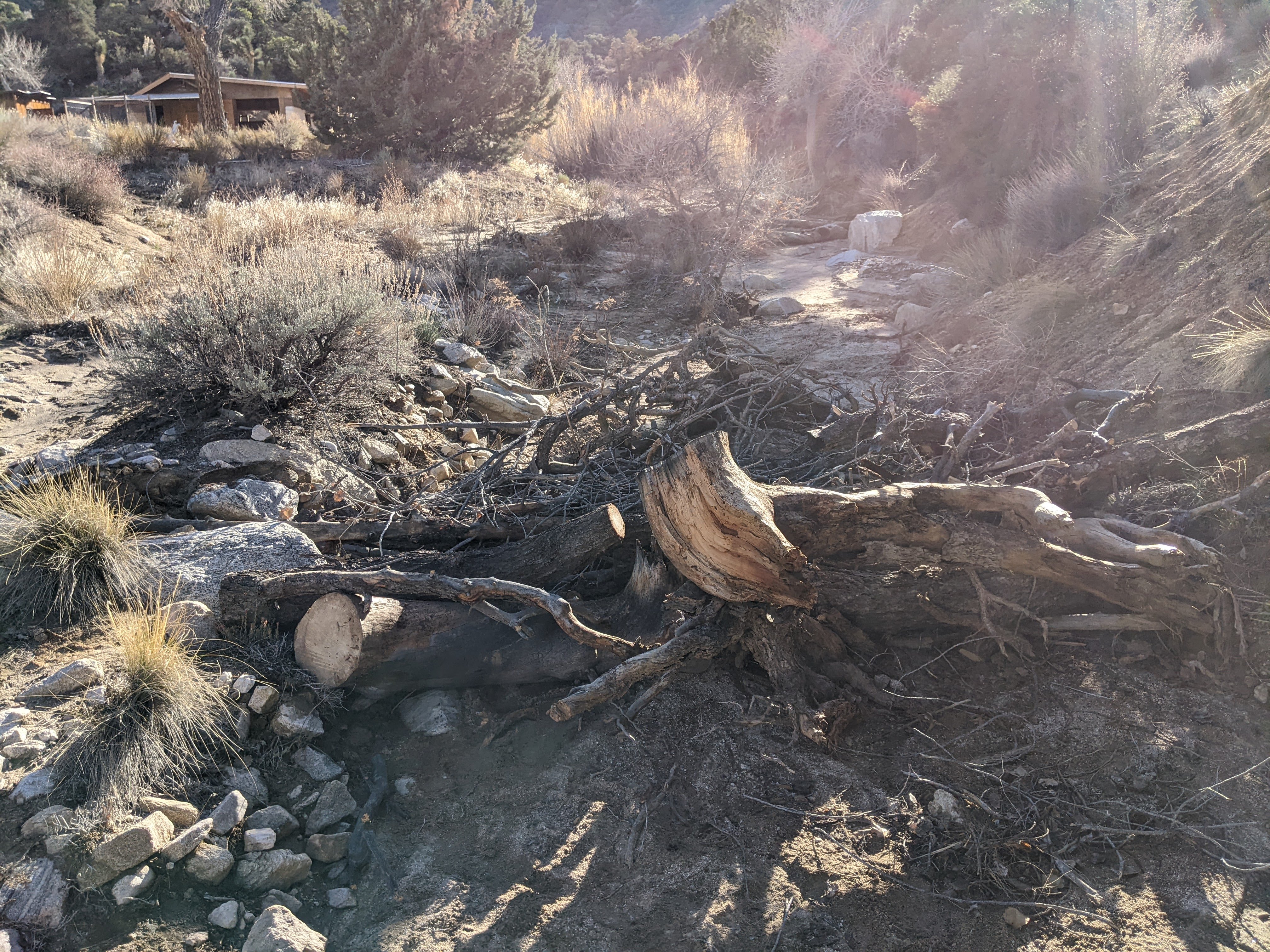
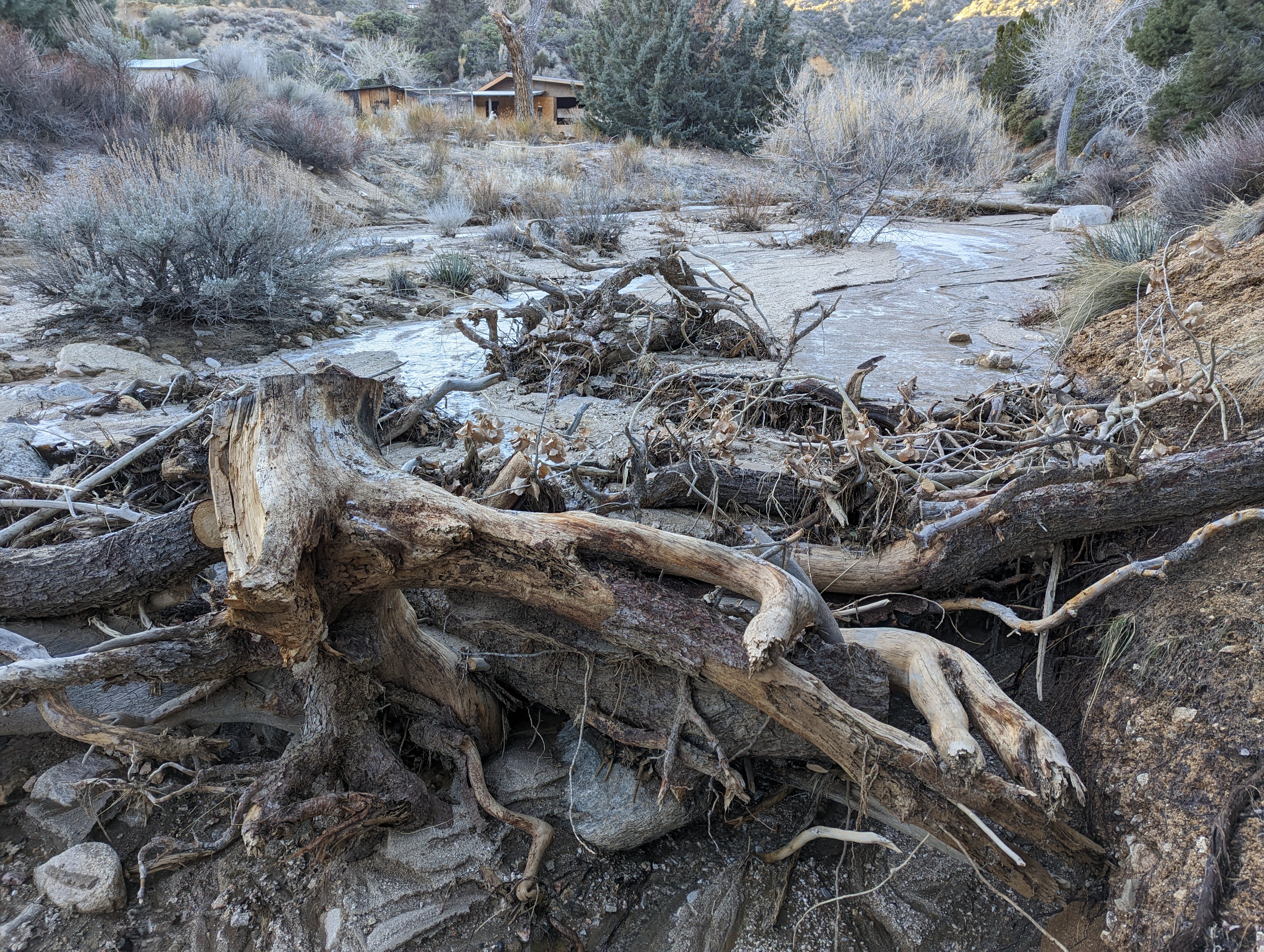
Solving two problems in one task. Fire hardening the land while slowing and spreading the water that seasonally runs across the land.


Sure enough the rains came and the clay, sand and rocks piled up burying the "firewood" and allowing the water to slow down and spread out. Check out the sand delta terrace piled up behind the "beaver dam"!
 
Skyler Weber
Posts: 152
Location: Southern Colorado, 6300', zone 6a, 16" precipitation
33
  • Likes 4
  • Mark post as helpful
  • send pies
    Number of slices to send:
    Optional 'thank-you' note:
  • Quote
  • Report post to moderator
This is neither the best nor the most efficient way to get your water shed, but it works and it is what I used - google earth. So you use the draw tool and track the elevation. You start your first point at one side of the arroyo and then go uphill. Keep your eye on the elevation meter. If the elevation keeps increasing then its your water shed. As soon as elevation starts dropping, then you have crested over the edge of the watershed and there you should drop your point. Move your cursor to side and hunt for the next point along the crest. Eventually you will circle around to the other side of the arroyo and then you can complete the polygon. Then you can use the area tool to get your acreage.
 
Eric Lyle
Posts: 42
Location: Llano, Ca
7
  • Mark post as helpful
  • send pies
    Number of slices to send:
    Optional 'thank-you' note:
  • Quote
  • Report post to moderator

Skyler Weber wrote:Then you can use the area tool to get your acreage.


Thank you, I had built a watershed polygon in google earth already but for some reason didn't try the measurement tool. 16,637 ft perimeter and 1.04 kmĀ² area.

 
Eric Lyle
Posts: 42
Location: Llano, Ca
7
  • Likes 3
  • Mark post as helpful
  • send pies
    Number of slices to send:
    Optional 'thank-you' note:
  • Quote
  • Report post to moderator
Why did we buy this property? Because of the watershed, small enough to not be a threat and yet much larger than our 20 acres. All the water that falls in that watershed flows through our property. The reality of slowing it all down isn't realistic after experiencing it first hand, the might of that force was sobering but certainly worth tackling and experimenting along the way. I was fascinated by how small changes captured the flows of clay and sand especially when it comes to back filling if the velocity can be reduced. Here is an example of a washed out eroded part of our road restored by using some old lumber and a carpenters level. So simple, by slowing the flow the clay and sand deposited and back filled, spread out into a beautiful flat space again.

 
master pollinator
Posts: 1745
Location: Ashhurst New Zealand (Cfb - oceanic temperate)
533
duck trees chicken cooking wood heat woodworking homestead
  • Likes 2
  • Mark post as helpful
  • send pies
    Number of slices to send:
    Optional 'thank-you' note:
  • Quote
  • Report post to moderator
That's impressive, Eric. Does any of your catchment reach high enough in elevation that snowmelt will be a factor?
 
Skyler Weber
Posts: 152
Location: Southern Colorado, 6300', zone 6a, 16" precipitation
33
  • Likes 3
  • Mark post as helpful
  • send pies
    Number of slices to send:
    Optional 'thank-you' note:
  • Quote
  • Report post to moderator
Wow that's alot of erosion. So at 1.04 square kilometers you should have a drainage area of 256 acres. Without doing the math, I can estimate that the arroyo is recieiving hundreds of thousands of gallons of water annually. That's more than enough to get something wonderful going. That wood dam is fantastic, though I would recommend you put stone dams together and it looks like you have no shortage of stone. The Quiviria Coalition has several field guides on hand made check dams here https://quiviracoalition.org/category/technical-guides/one-rock-dam/

I think you could do peach trees. I remember Geoff Lawton in one of his youtube videos saying that the Nabateans in the Negev desert would plant their peach trees in the wadis next to their stone check dams.
 
steward
Posts: 16058
Location: USDA Zone 8a
4272
dog hunting food preservation cooking bee greening the desert
  • Mark post as helpful
  • send pies
    Number of slices to send:
    Optional 'thank-you' note:
  • Quote
  • Report post to moderator
I agree with Slyler about the stone dams, brush dams, and check dams.

It will be easy with those to redirect that water to do some good and stop the erosions.

 
Eric Lyle
Posts: 42
Location: Llano, Ca
7
  • Likes 1
  • Mark post as helpful
  • send pies
    Number of slices to send:
    Optional 'thank-you' note:
  • Quote
  • Report post to moderator

Phil Stevens wrote:That's impressive, Eric. Does any of your catchment reach high enough in elevation that snowmelt will be a factor?


This year yes we have snow melt, I think it's not common every year. I was surprised by all the gold flakes on the small banks of the mini stream. Gold fever is setting in lol.
 
Eric Lyle
Posts: 42
Location: Llano, Ca
7
  • Likes 4
  • Mark post as helpful
  • send pies
    Number of slices to send:
    Optional 'thank-you' note:
  • Quote
  • Report post to moderator

Skyler Weber wrote:Wow that's alot of erosion. So at 1.04 square kilometers you should have a drainage area of 256 acres. Without doing the math, I can estimate that the arroyo is recieiving hundreds of thousands of gallons of water annually. That's more than enough to get something wonderful going. That wood dam is fantastic, though I would recommend you put stone dams together and it looks like you have no shortage of stone. The Quiviria Coalition has several field guides on hand made check dams here https://quiviracoalition.org/category/technical-guides/one-rock-dam/

I think you could do peach trees. I remember Geoff Lawton in one of his youtube videos saying that the Nabateans in the Negev desert would plant their peach trees in the wadis next to their stone check dams.


Thank you very much for this resource! Even though there seems to be a lot of stones in reality there is not so many. One idea I have is to use lime added to a normal concrete mix and build check dams or terraces in the stream bed using the sand and aggregate already there. One benefit of that would be the ability to completely level the top which is super important to fully spread out the force of the water and backfill. Surprisingly important to have a true level otherwise even a small amount of the water redirects and erodes small then larger areas. I played for hours in the stream bed while it was flowing experimenting with stones, planks, cast iron sewer pipes and brush. The more exact the level the better the results of back filling the eroded areas.
 
Eric Lyle
Posts: 42
Location: Llano, Ca
7
  • Likes 1
  • Mark post as helpful
  • send pies
    Number of slices to send:
    Optional 'thank-you' note:
  • Quote
  • Report post to moderator

Anne Miller wrote: I agree with Slyler about the stone dams, brush dams, and check dams.

It will be easy with those to redirect that water to do some good and stop the erosions.


The stone dams was a great recommendation and is already helping me redirect the creek to the higher sand bars on either side so now the trickle is already transferring some sand and silt back into the washed out bed.

There are not a lot of stones but enough and the sand clay is easily moved to make a sturdy check damn. I am thinking about laying staked limber on top of these check dams before the next rainfall using a carpenters level to force the water to spread out and slow down which should encourage the clay, sand and stones to back fill.

Today I thought about burying a water reservoir in the creek bed to fill when there is excess water running that I can not catch. Pump it out with a solar pump later when needed. It could also be part of a larger landform in the wash. It would need to be protected from abrasion. Any thoughts welcome!


PXL_20230419_182531784.jpg
[Thumbnail for PXL_20230419_182531784.jpg]
 
The time is always right to do what is right. -Martin Luther King Jr. / tiny ad
Switching from electric heat to a rocket mass heater reduces your carbon footprint as much as parking 7 cars
http://woodheat.net
reply
    Bookmark Topic Watch Topic
  • New Topic