• Post Reply Bookmark Topic Watch Topic
  • New Topic
permaculture forums growies critters building homesteading energy monies kitchen purity ungarbage community wilderness fiber arts art permaculture artisans regional education skip experiences global resources cider press projects digital market permies.com pie forums private forums all forums
this forum made possible by our volunteer staff, including ...
master stewards:
  • Carla Burke
  • Nancy Reading
  • John F Dean
  • paul wheaton
  • r ranson
  • Timothy Norton
  • Jay Angler
stewards:
  • AndrĂ©s Bernal
  • Pearl Sutton
  • Anne Miller
master gardeners:
  • Christopher Weeks
gardeners:
  • M Ljin
  • Jeremy VanGelder
  • thomas rubino

New land and would like design ideas

 
pollinator
Posts: 1793
Location: Wisconsin, zone 4
97
  • Likes 2
  • Mark post as helpful
  • send pies
    Number of slices to send:
    Optional 'thank-you' note:
  • Quote
  • Report post to moderator
The red X is where the house, shop, etc will be.  The blue is water, but it's mostly a trickle in that area at the top, and the blue line running vertically is spring runoff.  There are a number of spots like that.  A couple very small springs.  The area that looks like a small pond is more like a puddle right now  
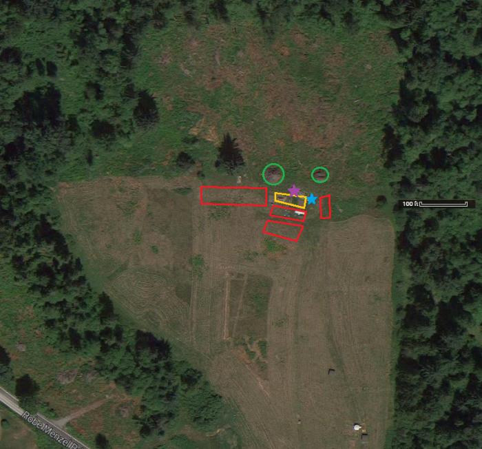
The land is quite hilly, and has a rocky ridge area on quite a bit of it.  The green circle is currently a food plot for deer, but will probably be an area I plant with bee food and will have a few Perrone hives at the bottom edge near the pines.

I need to find one of those maps that shows elevation, but I'm not sure yet where to get one.  Without that, I know it's very hard to get any kind of a plan going, so I'll try to get one.

The brown spot is nothing, just took the location off.

Land.JPG
[Thumbnail for Land.JPG]
New land
 
pollinator
Posts: 867
222
  • Mark post as helpful
  • send pies
    Number of slices to send:
    Optional 'thank-you' note:
  • Quote
  • Report post to moderator
The USGS website should have topographic maps for free. I think they refer to them as 'quadrangles' and you have to find the section that your land fits in and download it. Like most government websites it's pretty labrynthine but it's all free.
 
Todd Parr
pollinator
Posts: 1793
Location: Wisconsin, zone 4
97
  • Mark post as helpful
  • send pies
    Number of slices to send:
    Optional 'thank-you' note:
  • Quote
  • Report post to moderator

stephen lowe wrote:The USGS website should have topographic maps for free. I think they refer to them as 'quadrangles' and you have to find the section that your land fits in and download it. Like most government websites it's pretty labrynthine but it's all free.


Thanks Stephen.  I checked it out and my area isn't available there, but I appreciate you taking time to post.
 
s. lowe
pollinator
Posts: 867
222
  • Mark post as helpful
  • send pies
    Number of slices to send:
    Optional 'thank-you' note:
  • Quote
  • Report post to moderator
hey todd, I know for a fact that USGS has topo maps of the entire continental US. I just took a GIS course earlier this year and now I can't for the life of me remember the main website we used to get government data. But searching a bit I found this one national map viewer that might get you something. Like I said, I know they have them but the main thing I took away from my GIS course was that government is nothing if not good at making things harder than they should be. Ill reply again if I remember the source for all the maps and aerial imagery that USGS has.
 
steward
Posts: 22303
Location: Pacific Northwest
12891
12
homeschooling hugelkultur kids art duck forest garden foraging fiber arts sheep wood heat homestead
  • Mark post as helpful
  • send pies
    Number of slices to send:
    Optional 'thank-you' note:
  • Quote
  • Report post to moderator
You could also try http://www.digital-topo-maps.com/topo-maps.shtml. Your county might also have spiffy maps on it's county website... though I don't know if all counties have county websites.
 
Posts: 14
  • Likes 1
  • Mark post as helpful
  • send pies
    Number of slices to send:
    Optional 'thank-you' note:
  • Quote
  • Report post to moderator
There's a free phone app called US Topo Maps Free that will plot your GPS location on your local quad map right on your phone. Having worked as a surveyor I highly recommend this app to anyone spending time outdoors, it's quite good.
 
Why is the word "abbreviation" so long? And this ad is so short?
The new kickstarter is now live!
https://www.kickstarter.com/projects/paulwheaton/garden-cards
reply
    Bookmark Topic Watch Topic
  • New Topic