|

|
|
|
|

|

|

|

|

|


My project thread
Agriculture collects solar energy two-dimensionally; but silviculture collects it three dimensionally.
 3
3
My project thread
Agriculture collects solar energy two-dimensionally; but silviculture collects it three dimensionally.


 3
1
3
1
Matu Collins wrote:
One example is the loop, meaning a way for children to run around the house without crashing into each other or having grownups tell them to stop. When I had my first baby the home was designed with a central hallway that each room opened off of. No loop.
You reap what you sow
1
My project thread
Agriculture collects solar energy two-dimensionally; but silviculture collects it three dimensionally.
My project thread
Agriculture collects solar energy two-dimensionally; but silviculture collects it three dimensionally.
 1
1


Paul Cereghino- Ecosystem Guild
Maritime Temperate Coniferous Rainforest - Mild Wet Winter, Dry Summer
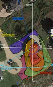
Matu Collins wrote:Can anyone steer me toward a program to create a zone map like the ones above? There must be a simple way to make the overhead photo one layer and overlay with other layers showing zones and sectors.

My project thread
Agriculture collects solar energy two-dimensionally; but silviculture collects it three dimensionally.
Cj Verde wrote:Google maps or GoogleEarth are great for the satellite image. Then, use the program you're most familiar with to do your layers - even if that's manually with onion skin paper and colored pencils.
I'm on a mac and used Pages and preview.
Here is a good design tools thread from a forum someone created for the design project of Geoff Lawton's online PDC. That's where I met Jenn (& convinced her to check out permies, I think).
“Enough is as good as a feast"
-Mary Poppins
Matu Collins wrote:I was hoping to do this work on my computer. Flat surfaces are at a premium in a house with so many people. Plus, I'm excited to use this computer, I put off getting a new one for years.
I have looked at the google maps image but I don't know how to get a copy of it to work with.
My project thread
Agriculture collects solar energy two-dimensionally; but silviculture collects it three dimensionally.
Matu Collins wrote:I have looked at the google maps image but I don't know how to get a copy of it to work with.
My project thread
Agriculture collects solar energy two-dimensionally; but silviculture collects it three dimensionally.
Projects, plans, resources - now on the Permies.com digital marketplace.
Try the Everything Combo as a reference guide.

|
Shiny ad:
It's a bit like "run away to the circus" but for gardeners
https://wheaton-labs.com/bootcamp
|