I was just curious if anyone else uses CAD for laying out their homesteads? By CAD I mean cardboard Aided Design!!

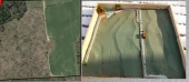
I like cardboard because I can make a wooden shadowbox, then using LIDAR Maps and their 2 foot contours lay out such things as access roads, swales, ponds, fencing, and other features.
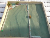
It took me two years granted, and in the end a little extra help, but I just managed to clear some land of forest products, and now am at the real planning stage. With all the snow, I really cannot get on the land just yet, so I set out to do a relief map. In this case I wanted to see how big and how deep a proposed pond will be. It won't be big, only 100 x 100 feet roughly. but will be much deeper than I thought at 18 feet. That is good information to know. I also laid out two heavy haul roads that will need to be built, and have a really good idea where the culverts for those roads will go, and where my resulting swales will be made. We are not ready for this just yet, but we are even using this to get a feel for how our future underground retirement home might fit into the layout.
I used 1:600 for a map scale and it seems to work well. The shadow box not being cumbersome to move around, yet not so small that I could not visualize some of the details.
I have a long ways t go as I finish off the layers of cardboard with drywall compound, some outcroppings of rock, and of course paint, but its a start!


 1
1


![[Thumbnail for Named-Relief-Maps.jpg]](/t/82874/a/59330/Named-Relief-Maps.jpg "Filename: Named-Relief-Maps.jpg
Description:")