• Post Reply Bookmark Topic Watch Topic
  • New Topic
permaculture forums growies critters building homesteading energy monies kitchen purity ungarbage community wilderness fiber arts art permaculture artisans regional education skip experiences global resources cider press projects digital market permies.com pie forums private forums all forums
this forum made possible by our volunteer staff, including ...
master stewards:
  • Carla Burke
  • Nancy Reading
  • John F Dean
  • Jay Angler
  • paul wheaton
  • r ranson
stewards:
  • Pearl Sutton
  • Leigh Tate
  • Liv Smith
master gardeners:
  • Christopher Weeks
  • Timothy Norton
gardeners:
  • Jeremy VanGelder
  • Matt McSpadden
  • thomas rubino

What Tool Is Used To Measure Soil Depth?

 
Posts: 75
Location: North Central Idaho - Zone 6B/7A Average Rainfall: 27 inches
14
books chicken medical herbs seed homestead composting
  • Mark post as helpful
  • send pies
    Number of slices to send:
    Optional 'thank-you' note:
  • Quote
  • Report post to moderator
What tool is used to measure soil depth (e.g. when evaluating land)?

I was picturing a probe consisting of a slender steel rod...perhaps with an augur tip and/or T-handle.

When I search for 'soil depth probes' online, however, the search results seem to consist mainly of soil coring tubes and moisture-sensing instruments.

Is there some other name for this tool? Does it even exist?
 
pollinator
Posts: 4958
1194
transportation duck trees rabbit tiny house chicken earthworks building woodworking
  • Likes 3
  • Mark post as helpful
  • send pies
    Number of slices to send:
    Optional 'thank-you' note:
  • Quote
  • Report post to moderator
I know this sounds snide, but really the only thing you can use is a drill rig if you want a physical means in which to measure.

With a probe, you will only get down to the compacted depth, which is most often "plow depth" which is about 14 inches down. Even in areas not tilled by humans, this is the compacted layer typically.

Really though, I have always found the USDA-NRCS soil reports "depths to restrictive soil" to be very accurate. They use lasers to make this determination. Where I live, here in Maine, where bedrock averages less than 10 feet deep, that means bedrock. In my gravel pit, where the depth is almost 32 feet to bedrock (confirmed by a drill rig) they are as accurate using lases, and in complete agreement with our mineral report, so I have confidence in what I read from their online soil reporting

You will find all that information on the USDA-NRCS website called "Web Soil Survey". Just do not be confused, it says "checkout", but as with everything with the USDA-NRCS, it is free.
 
pollinator
Posts: 298
Location: Ozarks
78
homeschooling goat dog building wood heat homestead
  • Likes 2
  • Mark post as helpful
  • send pies
    Number of slices to send:
    Optional 'thank-you' note:
  • Quote
  • Report post to moderator
A T shaped rod with somewhat pointed end will tell you how deep the hard pan is, if there's a hard pan. Slightly harder to tell when it goes from top soil to subsoil, depending on the make up of them.

You can get an idea of soil makeup, top to sub, here https://websoilsurvey.sc.egov.usda.gov/app/WebSoilSurvey.aspx
 
Donner MacRae
Posts: 75
Location: North Central Idaho - Zone 6B/7A Average Rainfall: 27 inches
14
books chicken medical herbs seed homestead composting
  • Mark post as helpful
  • send pies
    Number of slices to send:
    Optional 'thank-you' note:
  • Quote
  • Report post to moderator
Thanks for both of your replies.

"I know this sounds snide, but..."

Hm. A long hmm....

Nope! No snideness detected.

"...you will only get down to the compacted depth... Even in areas not tilled by humans, this is the compacted layer typically."

I'm not sure I get your meaning. Are you saying there's a compacted layer at this depth separate from the restrictive layers catalogued by the USDA (i.e.: fragipan, lithic & paralithic bedrock) which a probe wouldn't be able to get through, but which doesn't otherwise restrict the growth of food crop and tree roots?

The parcel I'm currently looking at is rated 20 to 46 inches to fragipan. That is quite a large range, and is why I wanted to take a shovel and/or probe. If the usable depth is toward the shallow end of that range, I'm gonna be forced to look elsewhere. If it's 46 inches, on the other hand, I'll probably be jubilant.

"A T shaped rod with somewhat pointed end will tell you how deep the hard pan is, if there's a hard pan."

That's what I was thinking - have you tried this before?
 
Donner MacRae
Posts: 75
Location: North Central Idaho - Zone 6B/7A Average Rainfall: 27 inches
14
books chicken medical herbs seed homestead composting
  • Mark post as helpful
  • send pies
    Number of slices to send:
    Optional 'thank-you' note:
  • Quote
  • Report post to moderator
I could easily make this tool if I knew the type and diameter of steel rod needed. The "probe" part would need to be slender enough to penetrate relatively deeply into the soil with a push (or a series of taps), yet rigid enough not to bend under the load.
 
Posts: 44
Location: Porto, Portugal
5
  • Likes 3
  • Mark post as helpful
  • send pies
    Number of slices to send:
    Optional 'thank-you' note:
  • Quote
  • Report post to moderator


I use this kind of take away tools to deposit samples in cardboard boxes 60 cm long and a square section of 10 or 15 cm when I want to assess the evolution of a soil after planting bamboo I took your samples on a fixed date for example you take them every three months

Jean Pierre Michotte
 
Posts: 664
Location: Australia, New South Wales. Köppen: Cfa (Humid Subtropical), USDA: 10/11
3
transportation hugelkultur cat forest garden fish trees urban chicken cooking woodworking homestead
  • Likes 2
  • Mark post as helpful
  • send pies
    Number of slices to send:
    Optional 'thank-you' note:
  • Quote
  • Report post to moderator
If I recall from my university days, there's a few choices: a soil sampling auger/probe, GPR, or, excavating trenches at various locations.

The best method was to actually excavate trenches to the desired depth (usually up to six feet deep), clean up one side of the trench with a trowel and brush, then measure the layers between their horizons.

This gives an accurate indication of the soils characteristics and how to best work it.
 
Jean Pierre Michotte
Posts: 44
Location: Porto, Portugal
5
  • Mark post as helpful
  • send pies
    Number of slices to send:
    Optional 'thank-you' note:
  • Quote
  • Report post to moderator


There are many techniques to sample the soils
    - the surveys for construction
    - Pedological surveys
    - The mineral or oil research is using drilling rig with a coring tool (manufacture for example Husqvarna old Diamond-Board)

   I think in our time the manual tools, disturb the profile. Many years ago, I was in the Sahara to monitor the usage of our tools.
Jean Pierre Michotte.
 
gardener
Posts: 6814
Location: Arkansas - Zone 7B/8A stoney, sandy loam soil pH 6.5
1641
hugelkultur dog forest garden duck fish fungi hunting books chicken writing homestead
  • Likes 5
  • Mark post as helpful
  • send pies
    Number of slices to send:
    Optional 'thank-you' note:
  • Quote
  • Report post to moderator

Donner MacRae wrote:I could easily make this tool if I knew the type and diameter of steel rod needed. The "probe" part would need to be slender enough to penetrate relatively deeply into the soil with a push (or a series of taps), yet rigid enough not to bend under the load.


The type of probe you are looking for is constructed of steel rod (in school we used rebar that was 1/2 inch diameter for the rod and 3/4" rebar for the T handle which was welded to the 1/2" rod.
The tip of the rod was then sharpened with a grinder, there were two flat sides and the tip was then shaped to a 35 degree point, this was stuck into the soil being tested and twisted down into the soil.
We also made one with a spiral twist (like a drill bit) at the tip end, it was found to not work quite as well as the straight, flat sided bit.
When it stops going down, even with a great deal of force, you have found the practical end of the soil. (it may or may not be bed rock)

If you want to know the different soil horizons your best tool is a backhoe to dig a trench (as others have mentioned) then you scrape one side of the ditch so you can clearly see the soil structure and where color and compaction lines lay.

Redhawk
 
Jean Pierre Michotte
Posts: 44
Location: Porto, Portugal
5
  • Likes 1
  • Mark post as helpful
  • send pies
    Number of slices to send:
    Optional 'thank-you' note:
  • Quote
  • Report post to moderator
    You are all right !

My experience can be described as follows :
    - Use of the right auger to monitor the evolution of a soil in a farm in different places to advise the farmer
    - I used the trench method which is heavy and hard  work only to report to official bodies on the pedological profile of polluted land,
    - I used diamond tools to be controlled by a truck mounted drill to explore geological situation for cobalt copper diamond, or water et cetera
    - For oil well it was a material of a whole other dimension...

So see everyone is right simply

Jean Pierre Michotte.
 
Travis Johnson
pollinator
Posts: 4958
1194
transportation duck trees rabbit tiny house chicken earthworks building woodworking
  • Likes 1
  • Mark post as helpful
  • send pies
    Number of slices to send:
    Optional 'thank-you' note:
  • Quote
  • Report post to moderator
As you guys know, I explore a lot of mineralization on my farm, and these are some additional "tests" I use to determine where the good minerals are. I present these to show that there are many good ways to draw conclusions on what is in the soil, without soil sampling every few hundred feet.

Gold/Silver/Platinum Group Metal assays are super expensive, but I do use them on occasion once I narrow in on an ore body that is showing good promise for those minerals.

For a cheaper method, I often use run-of-the-mill soil testing, and look for indicator minerals like iron, zinc and copper. Because these tests are so cheap, I can do many, all over the place, and get a feel for what is in the soil. It does not tell me gold/silver or pgm, but by indicators, it will take me where they most likely are. For instance gold "wears an iron hat", and PGM's like copper, nickel and zinc.

If I want to check an entire watershed, I will soil test the sediment in a stream. Again this will test 100's of acres for $12. Again I am looking for indicator minerals. With this test, it will tell me if I want to go into the watershed area for more testing, or not.

For an expensive, but all-inclusive test, I can do water sample and have a heavy metals test done. I use this for a very promising body of ore. I let the pulverized rock sit in distilled water for a long time and steep, then see what I have for minerals in the water like lead, cadmium, iron, copper, silver, etc...

Of course I spot check streams for gold, silver and pgm's.

For checking the frequency of quartz veins in the bedrock, I will "trench". If the soil is a few feet to bedrock, I rent an excavator, but if it is just under the surface of the soil, I use my tractor and plow to roll the soil over. I recently did a 1/4 mile trench and deduced that quartz veining is tracking at 118 degrees, 85 degree dip every 20-40 feet. That made me smile!


Travis Johnson
pollinator
Posts: 4958
1194
transportation duck trees rabbit tiny house chicken earthworks building woodworking
  • Likes 2
  • Mark post as helpful
  • send pies
    Number of slices to send:
    Optional 'thank-you' note:
  • Quote
  • Report post to moderator
I also use a ton of maps.

My favorite is LIDAR because I can see through vegetation. This often helps me see the rock walls we have in the forest, and rock walls show what kind of rocks are in the area. I have found tons of quartz veins by triangulating where the quartz veins cross the rock walls. But LIDAR also means you can convert them into 2 foot contours, and you can see where the water is flowing across the land when looking at 2 foot contours instead of 20 foot contours.

Another favorite map is the Surficial Maps. That tells you were the soil was deposited too from the glacier days. It also helps you find gravel deposits. Since these are contour maps too, it helps you visualize what was here before the glaciers came, and just where the soil in a given area went too. These really are my go-to soil maps.

Bedrock maps: what can I say, nothing like the source to tell you what is here. Not where it was and where it might be, but where it is now. It also tells you dip and strike of the exposed bedrock in the area, so play connect the dot, and a lot of vaulable information arises.

Fault Line Maps: Nope, they are not just in California, fault lines are everywhere, including my house here in Maine. I live just 1 mile from a major fault line that is identical to the San Andria's Fault Line. All a fault is, is a continuous crack in the bedrock, and that is why I have so much mineralization here When the tectonic plates bumped together, they hit here first, heaving my farm up into the huge ridge that it did. Its also where magma poured up through the earths surface...and with it diseminated quartz.

Soil Maps: While these change a lot due to human interference, from PH levels, I can hone in on some types of mineralization. Most soil is around 6.0 in PH here, but I have found anomaloes of 8.1. Why the difference? High amounts of sulfur, and sulfur means magma tracts through thh soil...mineralization!

The point is, all this is a 7000 acre scavenger hunt trying to find something that cannot be seen, and by using everything in intense study, you find the hidden gems. It is not just one aspect that gets you what you are looking for, its all of it combined. I am looking for minerals, but EVERYONE can use these same methods to find out what their land has. It might not be gold, but it could be organic matter, major minerals, etc. What do you have for bedrock? Where did you soil migrate from? How fast is the water moving through your soil?
 
Donner MacRae
Posts: 75
Location: North Central Idaho - Zone 6B/7A Average Rainfall: 27 inches
14
books chicken medical herbs seed homestead composting
  • Mark post as helpful
  • send pies
    Number of slices to send:
    Optional 'thank-you' note:
  • Quote
  • Report post to moderator

Bryant RedHawk wrote:

The type of probe you are looking for is constructed of steel rod (in school we used rebar that was 1/2 inch diameter for the rod and 3/4" rebar for the T handle which was welded to the 1/2" rod.
The tip of the rod was then sharpened with a grinder, there were two flat sides and the tip was then shaped to a 35 degree point, this was stuck into the soil being tested and twisted down into the soil.
We also made one with a spiral twist (like a drill bit) at the tip end, it was found to not work quite as well as the straight, flat sided bit.
When it stops going down, even with a great deal of force, you have found the practical end of the soil. (it may or may not be bed rock)

Redhawk


That's exactly what I was after, Redhawk. Many thanks, brother!

It's possible this info will save me the laborious task of digging all my test holes with a post hole digger & San Angelo bar.
 
Donner MacRae
Posts: 75
Location: North Central Idaho - Zone 6B/7A Average Rainfall: 27 inches
14
books chicken medical herbs seed homestead composting
  • Mark post as helpful
  • send pies
    Number of slices to send:
    Optional 'thank-you' note:
  • Quote
  • Report post to moderator

Travis Johnson wrote:

Bedrock maps: (...) It also tells you dip and strike of the exposed bedrock in the area, so play connect the dot, and a lot of vaulable information arises.


That could be helpful when evaluating land for food production. There've been times when a chunk of land had exposed (or shallow) bedrock in only one soil unit... If the strike and dip of the bedrock layer were known, one could make better inferences about usable soil depth of adjacent areas.

How does one obtain these bedrock maps?
 
John Pollard
pollinator
Posts: 298
Location: Ozarks
78
homeschooling goat dog building wood heat homestead
  • Likes 1
  • Mark post as helpful
  • send pies
    Number of slices to send:
    Optional 'thank-you' note:
  • Quote
  • Report post to moderator

Donner MacRae wrote:I could easily make this tool if I knew the type and diameter of steel rod needed. The "probe" part would need to be slender enough to penetrate relatively deeply into the soil with a push (or a series of taps), yet rigid enough not to bend under the load.


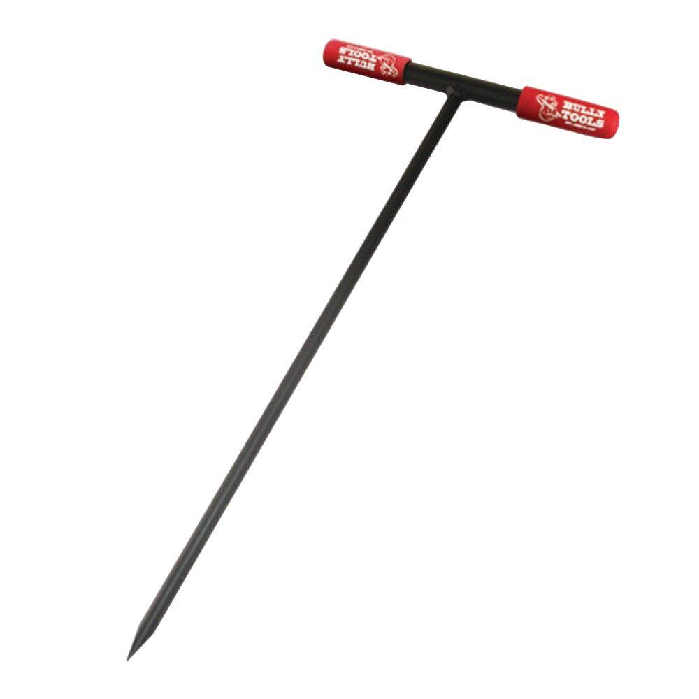
https://www.homedepot.com/p/Bully-Tools-36-in-Soil-Probe-with-Steel-T-Style-Handle-and-Sharpened-Tip-99202/205348126

The Bully Tools 36 in. Soil Probe

Durable tool is made to last
Features a steel T-style handle
1/2 in. Dia steel and sharpened tip
Comes with a limited lifetime warranty


Nothing wrong with 20 inches IF it's top soil. Can grow any veggie in that. For trees, you'd want to break through the fragipan if it's at 20"
Drainage is another story. You may want to dig a few holes to do drainage tests.

It's most likely going to be spotty so if there's an area that looks like a spot you'll be growing veggies, poke, prod and dig around there. I've been digging post holes lately and found 20" of top soil, a hard pan and then red clay. 60 foot away, I had 36 inches of top soil, no hard pan and then clay. Half way in between, I couldn't dig more than 30 inches due to many 6-12 inch rocks. Another 60 foot away, I had 12 inches of somewhat gravelly top soil, a hard pan and then VERY gravelly clay.
 
Donner MacRae
Posts: 75
Location: North Central Idaho - Zone 6B/7A Average Rainfall: 27 inches
14
books chicken medical herbs seed homestead composting
  • Mark post as helpful
  • send pies
    Number of slices to send:
    Optional 'thank-you' note:
  • Quote
  • Report post to moderator
Greetings John,

Looks like that'd do the job, doesn't it?

According to reviews, the body is all steel with rubber hand grips. One guy said it bent in use (I say, bend it back!)

I think I'm gonna pick up the 48".

Thanks for making this recommendation!
 
gardener
Posts: 815
Location: Ontario - Currently in Zone 4b
529
dog foraging trees tiny house books bike bee
  • Mark post as helpful
  • send pies
    Number of slices to send:
    Optional 'thank-you' note:
  • Quote
  • Report post to moderator
It really depends on how deep you are going and what you are looking for. I like to see soil texture in addition  to soil type, which requires a bigger sample. If you are interested in this, see below.  

inconspicuous 1 ft deep hole to check topsoil depth, like in someones yard:
Bring a pointed spade. Step it down into the earth and then lever forward. Check out soil. Remove spade. Stomp on the top to press bwck in place. I doubt anyone could ever find the hole.

For up to a 2 ft hole, I would rather dig than auger. It is fast, and tells me more.

Have you looked at soil sampling hand augers. You can go deep as they have connecting sections -I have heard of going 30 ft deep in good soil, but I personally can't imagine ever doing more than 15 ft or so without switching over to some sort of drill rig. https://www.ams-samplers.com/hand-tooling/soil-samplers/soil-augers.html is the first site I found with a quick google, I am sure other versions are available.
 
Jean Pierre Michotte
Posts: 44
Location: Porto, Portugal
5
  • Mark post as helpful
  • send pies
    Number of slices to send:
    Optional 'thank-you' note:
  • Quote
  • Report post to moderator
Dimensions of probes for soil analysis.


Let' see a theoretical profile


This is my choices.

  This diagram, which dates back to the 60's, is clearly pointing the problem for :
    - the examiner is using a hand-held auger (3-4 ")
    - to explore the horizons above the breastplate, we will eventually make a trench to see what the thickness of the of the breastplate and the nature of the underlying soil
    - to reach the underlying clay and to see their potential it will be necessary to take various samples (between 2-3")
         - to analyze them to know the composition in major nutrients (N,P,K,Mg,Ca,Fe chelates and especially the minor elements that often misses in Africa.
         - lets see Aquaponic or Hydroponic formulas (from GHE Europe or Hydroponic Food Production - Howard M. RESH  )
    - to reacg the source rock, use drill mounted on tractor as for a mining exploration (Huskvarna). (8")

Jean Pierre Michotte "
 
pollinator
Posts: 686
Location: northwest Missouri, USA
103
  • Likes 2
  • Mark post as helpful
  • send pies
    Number of slices to send:
    Optional 'thank-you' note:
  • Quote
  • Report post to moderator
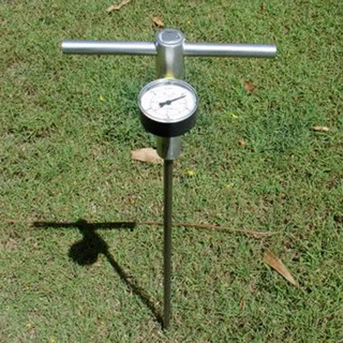
To take this concept to an additional level (see what I did there!) I would consider a soil penetrometer. This is an important compaction testing tool to help you better understand your soil profile. When combined with two other tests, you have a much clearer picture of what's going on in your pasture or field. The two other metrics I'd recommend are BRIX testing of the green growing matter on the soil and dry matter yield (this really is for pasture that is hayed). Loose soil, high BRIX value and high dry matter yield are excellent indicators your pasture is doing well.

Here's a penetrometer
 
Posts: 74
Location: Greater New Orleans, LA, USA
2
6
  • Mark post as helpful
  • send pies
    Number of slices to send:
    Optional 'thank-you' note:
  • Quote
  • Report post to moderator
If you just want to see how deep you can go before you hit rock, then a pipe probe may be all you need.  There should be some ~60".
 
Travis Johnson
pollinator
Posts: 4958
1194
transportation duck trees rabbit tiny house chicken earthworks building woodworking
  • Likes 3
  • Mark post as helpful
  • send pies
    Number of slices to send:
    Optional 'thank-you' note:
  • Quote
  • Report post to moderator
Perhaps this deserves its own topic, but I would be curious what the plan is after the tool is secured, used, and an analysis made?

There are no right and wrong answers by any means, it is just that some deep-depth soil work can be really beneficial. What I mean is, is there any interest in using a Yeoman Plow for keyline farming? Using a sub-soiler to break up deep compaction and promote drainage? Install field tiles to aid in drainage? Plant certain grass varieties for nitrogen fixation?

I know on my farm, 90% of the soil is within plow depth of bedrock. Yet alfalfa can drive a tap root twenty feet down still. they just work their roots into the cracks of the ledge and bring nitrogen down, and nutrients back up. I can also break up compaction, promote drainage, etc, and this is with thin soil.
 
Is that almond roca? Did you find it in the cat box? What is on this tiny ad?
Switching from electric heat to a rocket mass heater reduces your carbon footprint as much as parking 7 cars
http://woodheat.net
reply
    Bookmark Topic Watch Topic
  • New Topic