Jj wrote:Part of my problem is that it is too blank of a canvas. Im a very visual person, and since there are no visual boundaries other than the four corner point on my property, I was having a hard time imagining where everything should go.
I'm a spatially oriented guy myself, and I'd be quite happy to draw up a couple quick concepts to help you and others get started and visualize that blank canvas filling in. (There are some designs for a piece of land with very similar dimensions that I've had in the back of my head for a while now, and this might help me draw up something more concrete while honing my skills.)
First, some strategy discussion:
1. Zone design is a very useful concept indeed, but first take to heart Holmgren's 7th permaculture design principle here which goes: "
design from patterns to detail". In other words, think big picture, then smaller picture. Once you get what Geoff Lawton calls the "mainframe" figured out, everything else will fill in nicely. Caitlin already mentioned several patterns which will affect that mainframe: "sunlight, orientation, water, soil, current infrastructure and slope". But more importantly, all these patterns are oriented to
meet your goals, as well as the site's ecological needs.
2. A tool to help us design from big to small is the
Scale of Permanence. There are three that I know of: PA Yeoman's, Mollison and Holmgren's, and
Dave Jacke &
Eric Toensmeier's. The latter scale goes as follows:
Edible Forest Gardens page 193, Jacke & Toensmeier wrote:
ClimateLandformWaterLegal issuesAccess and circulationVegetation and wildlifeMicroclimatesBuildings and infrastructureZones of useSoil (fertility and management)Aesthetics
3. When talking and dreaming about your property with others, it may help to have a common mental picture model to serve as a reference. As an example, people from Michigan do this all the time, since the state looks like a glove. When they meet each other, they hold out their hand and point on their hand depicting where in the state they are from or trying to get to.
Piecing the above together.
Stated goals:
Want to make 4 acres pretty much self-reliantPlan to have goats, chickens, and sizable gardensTrying to lay out a small tree standHope to buy 3 more acres surrounding it
Stated context (+ my assumptions ):
South Louisiana (It's sub-tropics, hot and humid, very mild winters, possibility of hurricanes, probably flat but water probably tends to flow to the south, 45"-75" rain per year, possibility of future flooding?) Have a home on the property (Have sufficient water and electricity hookups)Family ownedNarrow property ~145' by 0.25 milesCurrently in hay (bacteria-dominated soil, probably quite fertile because of S. Louisiana)
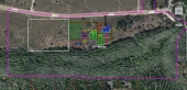
So I assume your property is likely shaped like a ruler. My guess is it looks something like this drawing, but the orientation/house location/road, etc. is likely off.
My immediate thoughts are:
1. Better site understanding, assessment, and base map
2. Do a quick sector analysis of your zone 0:
-Channeling cooling summer winds
-Understanding, mitigating and creatively using any flooding spots
-Protecting from hurricane's likely line of advance
3. Getting some mainframe pattern concepts tossed in there:
-Establish the cart paths & lanes pattern
-Reticulated water pattern for animals and gardens
-Earthwork possibilities / ponds
-Perimeter fencing
-Establish perennial browse strips for goats
-Shifting small paddocks / garden mosaic system (this would be easily implemented as a "ladder" shape, given a 100' leap-frogging electric fence.)
If you're interested let me know and I can post some quick drawings and ideas for free.


 5
5


Skill verified by gir bot")

Skill verified by Ash Jackson")

Skill verified by Mike Haasl")

Skill verified by jordan barton")

Skill verified by Mike Haasl")

Skill verified by Mike Haasl")

Skill verified by Nicole Alderman")

![[Thumbnail for little-garden-tractor-wagon.JPG]](/t/156123/a/133012/little-garden-tractor-wagon.JPG "Filename: little-garden-tractor-wagon.JPG
Description:")


Skill verified by Opalyn Rose")

Skill verified by Mike Haasl")

Skill verified by Opalyn Rose")