In addition to the work I do here at the Homestead, I also serve as the research coordinator for Exos Design (
http://exosdesign.com), a design company started by Douglas Bullock and landscape architect Scott Godfredson. When we do a site assessment one piece that we've started providing is called an Analogue Climates Assessment. I think it is an incredibly powerful tool, so I thought I'd share it with folks here with the hopes that others would make use of it as well.
Basically, we start by creating a climate profile for the site in question. Specifically, we will define the climate in terms of:
[li]Annual rainfall[/li]
[li]Average, maximum, & minimum temperatures[/li]
[li]Seasonality (When does the rain come? When is it dry? Does it snow?)[/li] In order to find this out we will try to find data collected over a long period of time. If someone in the neighborhood has been recording readings from a backyard weather station, you're in luck! The next best thing is to try to find a nearby weather station where data has been recorded and charts compiled. For the western states, a useful source for this information is the Western Regional Climate Data Center (
http://www.wrcc.dri.edu/index.html). Find a weather station that is close to you (not just geographically, but also in terms of elevation). They have information on everything from rainfall and temperatures to average last frost date and snowfall.
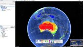
Once you have a fairly good picture of what your climate is like you can start the interesting part. Think about other places in the world with a similar climate. A useful tool to help with this is the Koeppen Climate Classification System (
http://en.wikipedia.org/wiki/K%C3%B6ppen_climate_classification). Essentially, this provides a map of the entire world divided into climate types. Figure out which of Koeppen's climate zones your site falls in and look for other places in the world that match. This system looks at climates in low resolution, so it won't tell you exactly where your matches are (Northeastern Illinois is in the same climate zone as South Central Florida). However, it will tell you where to start looking.
You can also use what you know about biogeography (look at similar north & south latitudes, similar elevations, similar biomes, similar plant communities, etc.). If you're lucky you'll be able to identify similar climates that are very specific (a specific elevation in a specific mountain range, a specific province in a country, etc.)
Once you identify the other parts of the world with a climate that matches yours you can use this information in a variety of ways.
[li]You can look at what comprises the natural ecosystems in these areas. This information can give you clues as to what kinds of plants will grow well where you are. For one project we found an analogue climate where 70% of the dominant forest cover was pistachios, almonds, & pomegranates![/li]
[li]You can look at the primary agricultural products of these areas. By figuring out what has been traditionally grown as well as what is commercially grown in these areas, you can get a great clue as to some crops to try where you are. We once found an analogue climate for a Northern California site in the Khorasan Province of Iran. This province's primary agricultural products were barberries and saffron. Guess what made our recommended plant list?[/li]
[li]You can research how indigenous & traditional peoples lived in these areas. What was their architecture like? What materials did they build with? How did they meet their needs? This kind of information is incredibly useful. Before we had the energy glut that followed the industrial revolution people had to live in a way that was responsive to their environment. For example, without the ability to heat and cool buildings with electricity or natural gas, the buildings had to be designed to stay cool in the summer and stay warm in the winter. You can save a lot of energy simply my choosing materials, siting, and designs that match your climate. We can figure out what those materials, siting choices, and designs were by looking at how people traditional did it.[/li]
Well, that's the basic deal with analogue climates. Researching this is actually one of my favorite things to do as part of a design project. Hopefully, you will find it useful as well.
In fact, it would be neat to see responses in this thread with people telling where they are and what they've found as analogue climates. Additionally, if anyone out there is a programmer, it would be huge to have analogue climate software that would help easily identify climatic matches worldwide. Permaculture designers would love it!
I'll be interested to see what kinds of places people come up with as analogues. Happy hunting!
Dave


 1
1