Morgan,
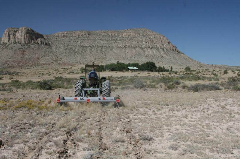
In the subsoiling pictures I posted of Circle Ranch the gradients were very flat and they very likely could have plowed along contours and not had problems.
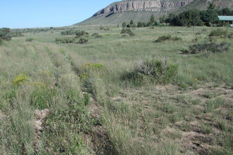
Where we are located the land is not so flat and we have to coax the water out of the draws and ravines with keyline ripping that gently falls through contours and helps to direct the water out to the drier ridge areas and forces the water to stay up higher on the land for a longer period of time.
Swales can work here, but it is not uncommon to get a large percentage of our annual rainfall in just a few rain events, or, even more common to have downbursts that are extremely intense even though their duration may only last for 10-20 minutes over a given area. Swales have to be heavily exaggerated to keep from being inundated and breached. The areas with thick clayey soils are also subject to heavy cracking when they dry out completely, and water can then easily tunnel through the cracks and ruin the effectiveness of a swale.
Keylining seems to get the water into the soil (sponge) more effectively where you have larger areas to cover. I also know from personal experience that I have some areas where digging swales will mean encountering rocks much larger than I can handle even with my mid-sized Kubota tractor, whereas I can keyline up to and over the same large rocks without having to blast a swale in my rock hillside. Obviously in areas that are solid rock neither swales or keyling ripping can be effective.
I gave a community presentation today on keyline ripping (Terlingua, TX "Green Scene") and gave the following demonstration for people to see with their own eyes how the concept can work.
1. Take a dry or gravely slope (ours was a sandy/gravel parking area) that is not particularly steep for demo purposes.
2. Tell the group you are going to pour water out and you want someone to show the group where the water will flow. Then take ~ 2 gallons of water and pour it out on one spot so the runoff gives a clear indication of the down slope direction of the land. Ask participants to agree that in nature water can only
flow downhill -- which they will readily agree is true.
3. Ask participants if I keep pouring water in the same location month after month and year after year what would happen to that area (erosion would obviously result).
4. With (4) fingers on one hand I scratched (4) ~ 1/8 inch deep grooves on the ground surface -- starting in the muddy path created by water flowing down slope in step 2 above, and moving out at an approximate 45 degree (envision " y ") angle relative to the natural flowline direction observed as the water moved down the sloped surface. These (4) finger scratches moved from the muddy area out into the drier dirt (downslope and sideways) with a total length of ~ 2 feet.
5. Take another 2 gallons of water and pour in the same location as # 2 above. Watch the water shoot down the already wetted path until the first grooves (representing keyline cultivation) are encountered. You will observe that a small amount of the total runoff sheeting down the path enters each of the grooves and almost magically starts to traverse downslope and sideways into dry soil areas that had not benefitted from any of the previous water.
6. Discuss with the group how the keylines coaxed the water to follow a new trajectory down the same general slope that had been dry in previous steps. Did the water reach the ends of your 2' long (keyline) grooves or was it soaked up before then? Pour more water and see if it continues to follow the grooves further out. Ask them to imagine an area with literally hundreds of more effective Keyline ripped grooves -- half going to one side of the original flow and half going out to the opposite side. How much water could those Keyline ripped grooves handle?
You can do the same dirt experiment but pour a little water out and use your finger or a stick to see how "shallow" of a downhill angle (groove) you can utilize to get water to flow and keep following your groove. A groove straight downslope will move a lot of water quickly, but erosion of soil particles can be readily seen. As the slope of your groove becomes more shallow (sideways relative to original flow line of water), less water will flow in a given size groove, but erosion of soil particles by water traversing the groove becomes almost nonexistent as you reach the practical limit of slope required for water to flow freely.
Experiment with a larger stick on that shallow groove to see more water flow in the same sloped channel.
Try this same water experiment with small swales that you construct. You will see that swales on contour are more prone to being breached and eroded by large flow events. Yes they are great for trapping water and getting it to infiltrate, but only as long as they remain viable.
Keyline cultivation happens inside the soil sponge and breaks hardpan and creates channels that roots can keep open and available for large flow events. As an example here is an excerpt from Chapter VI of P.A. Yeoman's 1958 book
The Challenge of Landscape http://www.soilandhealth.org/01aglibrary/010126yeomansII/010126toc.html:
"
A Keyline appreciation of the various land shapes enables a farmer to control all aspects of water almost at will. The accumulation of power to control water which is provided by many hundreds of little furrows, all combining for one effect, is unbelievable until it is seen. For instance, following a very heavy storm which fell during the severe flood rains of 1956, one of our lower dams on "Yobarnie" overflowed with a stream two feet six inches deep by about fifteen feet wide through the flood spillway which emptied into a small flat valley. The valley was in a paddock which was Keyline cultivated three years earlier as a part of an experiment. The experiment, which included two other paddocks, was to determine the different effects on soil and pasture development of Keyline cultivation; one cultivation in the autumn for one year, one in each autumn for two years, and one each autumn for three years. This paddock, cultivated once only, had been stocked on and off about twenty-five times in the three years. There was no noticeable Keyline cultivation pattern left, as the stock had tramped it out. But within a few feet of the spillway's outflow in the valley the old Keyline cultivation patterns had completely controlled this large water flow. The powerful cumulative influence of what was left of the Keyline pattern spread the water well over three hundred feet wide. The water flowing in the valley centre was not noticeably deeper than that flowing on the sides of the valley where it extended laterally almost to the ridge between this valley and the next. "
The end result is that the flows are spread out over large areas to soak in, not just put in a swale and concentrated along that contour.
Another thought experiment is natural game trails in hilly or mountainous terrain. You practically never see their trails going straight up or down any slope -- they take the scenic route via a less steep grade (keyline concept). If you snow ski and are not top notch do you take the black diamond trails that are really steep, going straight down the mountain at high speed, or do you take a route that meanders back and forth down the same mountain, but not at such high speed. Same concept as keyline cultivation where water can take its time going downhill on a less steep route. The end result is much less water makes it off the slope because it is spread out and soaked up by the earth.
Hope this visualization and thought experiments help you see the power behind Keyline cultivation.
Kevin


 5
5


![[Thumbnail for DSC00452.JPG]](/t/23298/a/8507/DSC00452.JPG "Filename: DSC00452.JPG
Description: Taper on front edge of ripper shank")
![[Thumbnail for DSC00449.JPG]](/t/23298/a/8508/DSC00449.JPG "Filename: DSC00449.JPG
Description: Shear pin part of the ripper shank")
![[Thumbnail for DSC00448.JPG]](/t/23298/a/8509/DSC00448.JPG "Filename: DSC00448.JPG
Description: Subsoil ripper attachment on my tractor")