• Post Reply Bookmark Topic Watch Topic
  • New Topic
permaculture forums growies critters building homesteading energy monies kitchen purity ungarbage community wilderness fiber arts art permaculture artisans regional education skip experiences global resources cider press projects digital market permies.com pie forums private forums all forums
this forum made possible by our volunteer staff, including ...
master stewards:
  • Carla Burke
  • Nancy Reading
  • r ranson
  • Jay Angler
  • John F Dean
  • Pearl Sutton
stewards:
  • Nicole Alderman
  • paul wheaton
  • Anne Miller
master gardeners:
  • Christopher Weeks
  • Timothy Norton
gardeners:
  • thomas rubino
  • Jeremy VanGelder
  • Matt McSpadden

Stillwater issue created by clearcutting

 
Posts: 107
13
  • Mark post as helpful
  • send pies
    Number of slices to send:
    Optional 'thank-you' note:
  • Quote
  • Report post to moderator
Hello all,

My first post! I'm hoping I'm in the correct forum for this question, while also hoping this question makes sense.

I'm considering purchasing a large parcel of boreal forest that had a top section clearcut back in 2005. After investigating the time-lapse satellite photos of the parcel on google-earth, its evident that a large 'stillwater' has developed in an area because of this clearcut. The body of water is approx. 275m X 85m. All the tree growth in this area has died, and there are many standing snags.

My question is: should anything proactive be done about this water? I'm concerned about possible flooding to other areas of the property from it. There is an established large creek approx 200m away. I've though about trenching and draining the stillwater into this but unsure if it would be a solution or the right thing to do.

The parcel has largely been neglected since 2005 and has nobody living on it, so it's difficult to truly gauge the effects of the clearcut other than google earth. One thing is obvious...clearcutting=not good.
 
Posts: 9002
Location: Victoria British Columbia-Canada
707
  • Mark post as helpful
  • send pies
    Number of slices to send:
    Optional 'thank-you' note:
  • Quote
  • Report post to moderator
The wet area may legally be a wetland. There are many laws to be examined, should this be the case.
 
Rocket Scientist
Posts: 4554
Location: Upstate NY, zone 5
586
5
  • Mark post as helpful
  • send pies
    Number of slices to send:
    Optional 'thank-you' note:
  • Quote
  • Report post to moderator
What leads you to believe that the clearcut itself caused the stillwater? Could some logging access activity have blocked a drainage? I would think undoing that would be allowable, but yes, check the legal situation carefully.
 
Michael Adams
Posts: 107
13
  • Mark post as helpful
  • send pies
    Number of slices to send:
    Optional 'thank-you' note:
  • Quote
  • Report post to moderator


The first image is from 2005, the cut was in 2001. The one below is 2013. I'm 99% positive the water is a direct result of the clearcut. The water is not a legal wetland.

 
Posts: 53
Location: Newfoundland
1
  • Mark post as helpful
  • send pies
    Number of slices to send:
    Optional 'thank-you' note:
  • Quote
  • Report post to moderator
There's several possibilities, with the creek nearby it's more than likely that the logging activity blocked or cut off the drainage to the creek as Glenn said.
It's also possible that the parcel is actually trees that grew in a boggy/swampy area, and with the trees gone plus the logging damage to the ground, the water simply gathered up. Logging companies -do- go into swamps, usually during the winters depending on the areas, and clear cut regardless of what's under the snow.
Clearcut logging, even when during the winter, still uses vehicles with massive tires more appropriate for mining trucks. I've seen haul out tracks that leave a rut in ground 6 feet deep, and when the areas more bog than land, they fill in, network and create small ponds. But nothing like what's in your picture.

There's also the possibility of it being the work of a beaver, even if it's not active and the beavers moved on, the dam's still there and even without 'maintence', keeps working for years.

The only way to find out would be to actually take a walk around the land parcel and ask someone local.
 
Glenn Herbert
Rocket Scientist
Posts: 4554
Location: Upstate NY, zone 5
586
5
  • Mark post as helpful
  • send pies
    Number of slices to send:
    Optional 'thank-you' note:
  • Quote
  • Report post to moderator
Is the creek off to the left of the image? The meandering lines on the left edge of the dark spot seem like they could be beaver dams. Ground verification is probably the only way to be sure. Where is the clearcut in relation to the dark area? I don't think there is any meaningful way the cutting itself could affect the water ponding a ways downhill from it.
 
Dale Hodgins
Posts: 9002
Location: Victoria British Columbia-Canada
707
  • Mark post as helpful
  • send pies
    Number of slices to send:
    Optional 'thank-you' note:
  • Quote
  • Report post to moderator
Your location is unclear to me. If you are in  Northern Ontario or Quebec, then the photos and what you're describing appears to be a black spruce bog. When beavers dam up an area and the dam fills over time, a boggy area is created. Black spruce is one of the few trees that can grow there. Their roots intertwine and capture debris to form relatively solid ground. Once gone, a shallow pond can develop.

 They could be re-established if the dirt is heaped into small hillocks that just break the surface. Check with the local forestry people concerning options.

I once bought a bush full of sugar maple tops for firewood. The skidder left trenches that completely altered drainage. Access that was drive able by pick up truck, for years before, became nearly impossible to cross with a 4 wheel drive tractor.
 
Michael Adams
Posts: 107
13
  • Mark post as helpful
  • send pies
    Number of slices to send:
    Optional 'thank-you' note:
  • Quote
  • Report post to moderator
Thanks for all the great replies. Dale, the location is Nova Scotia. I also thought it could be the work of beavers, however the timing of the google photos and reading about water pooling after clearcuts made me think of the latter as per Alice's suggestion. The creek is to the left of the photo. The clearcut happened all around where the water is now, approx 75 acres.

So, in regards to a possible flood, should I be concerned about this water that has formed over the last 10 years?
 
Alice Tagloff
Posts: 53
Location: Newfoundland
1
  • Mark post as helpful
  • send pies
    Number of slices to send:
    Optional 'thank-you' note:
  • Quote
  • Report post to moderator
Unless the creek feeds directly into it, I probably wouldn't be worried about it flooding.
That being said, beavers or not, that's probably a bog. There might not even be a suitable place to build on.
Even if there is a place to build on, the water's most likely brackish, and it's doing something to your water table. So obtaining drinking water's probably going to be an issue too.
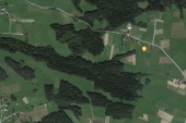
If the clear cut happened -around- where the water is, and not -over- it, then most likely the clear cutters did something to drain another area to this one, or their tracks did something to block a drainage. You'd pretty much have to take a look around the entire pond, and see if there's visible drainage into or out of that new pond on the surface. And it's obviously in a low area.
As long as you don't build right along side it(just think of all the mosquitos coming out of there), and find a relatively higher elevation, it should be okay. Ish. There's always something to be considered.
Play around with the geo location on Google Earth if you can't actually get to walk the site. It'll tell you the elevations. And then look around other mapping, topography sites with the land elevation and type markers, it should identify if it's a marsh/bog. If your serious enough, contact the local land survey offices and see if anyone has a topography survey.

Bogs are not usually considered wetlands, and they usually don't look like one either, sometimes it hard even with looking at it to tell that it's not solid ground, till your out in the middle of it and your loosing your ATV thru 10 feet of floating moss and practically have to sort of quick sand swim to a more solid edge and haul yourself out and have to hike 3 miles back to the nearest road(we have one really big bog out by my grandfathers cabin that usually swallows up at least one quad every 5-10 years because the guy driving isn't local and not familiar with bogs, and nearly lost our own quad when the bog was wetter then it should have been during a drought).
 
Glenn Herbert
Rocket Scientist
Posts: 4554
Location: Upstate NY, zone 5
586
5
  • Mark post as helpful
  • send pies
    Number of slices to send:
    Optional 'thank-you' note:
  • Quote
  • Report post to moderator
Since the clearcut was all around the now wet area, it was obviously impassable with logging equipment then or they would have cut it. I tend to think it was always a bog, and their work just made it a bit wetter, or else beavers came in.
 
Michael Adams
Posts: 107
13
  • Mark post as helpful
  • send pies
    Number of slices to send:
    Optional 'thank-you' note:
  • Quote
  • Report post to moderator
I'll be walking it this weekend, and will be sure to post an update on this. Thanks again.
 
Goodbye moon men. Hello tiny ad:
turnkey permaculture paradise for zero monies
https://permies.com/t/267198/turnkey-permaculture-paradise-monies
reply
    Bookmark Topic Watch Topic
  • New Topic