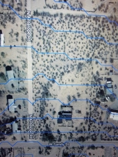
Jay, the flood plain maps were redrawn by FEMA and Pima County in 2010 and became official in 2011. These new maps greatly expanded the flood plain areas, much to the consternation of the residents which were impacted by now needing flood plain insurance and disclosure when selling. If you can find the old maps, and compare them to the new maps, it might give you a better historical sense of the flood danger on the land you are looking to buy. For instance, my parcel in central Tucson went from not being anywhere close to a flood plain, to now having half of my property in the new flood plain (which ironically is the highest part). So I just stand on the side that isn't in the flood plain when it rains and I'm good.

As you mentioned in your original post, you will be dealing with sheet flow (at least on the properties in the area you initially proposed). While Tyler's caution is appreciated, the link to the farm wiped out by flooding was in a canyon, which would likely be a bad idea in AZ. The amazing thing about the story Tyler posted is that they rebuilt the farm; not sure I would have come to the same conclusion. Having been on the land in the area that you are considering, it is fairly flat, with a very mild (maybe several feet) slope from east to west. Thus, large berms and basins (similar to the CCC swales) that overflow into one another should work to mitigate flood dangers, while also making use of that water when it does come. Vegetation will help immensely!
Just to be clear, I'm not suggesting that you disregard the flood plain information. I personally believe that given the amount of rainfall here, we need to work with this problem and turn it into a solution. The University of Arizona's very own Gary Paul Nabhan and one of his books 'Growing Food in a Hotter, Drier Land - Lessons from Desert Farmers on Adapting to Climate Uncertainty' has some examples of in-canyon flood plain farming and many other techniques. It's worth a trip to the library.


 1
1