• Post Reply Bookmark Topic Watch Topic
  • New Topic
permaculture forums growies critters building homesteading energy monies kitchen purity ungarbage community wilderness fiber arts art permaculture artisans regional education skip experiences global resources cider press projects digital market permies.com pie forums private forums all forums
this forum made possible by our volunteer staff, including ...
master stewards:
  • Carla Burke
  • Nancy Reading
  • r ranson
  • Jay Angler
  • John F Dean
  • Pearl Sutton
stewards:
  • Nicole Alderman
  • paul wheaton
  • Anne Miller
master gardeners:
  • Christopher Weeks
  • Timothy Norton
gardeners:
  • thomas rubino
  • Jeremy VanGelder
  • Matt McSpadden

Any Good Trail Mapping Apps?

 
pollinator
Posts: 165
Location: St. Andrews West, Ontario, Canada (Zone 5b)
43
hugelkultur forest garden trees foraging medical herbs homestead
  • Likes 1
  • Mark post as helpful
  • send pies
    Number of slices to send:
    Optional 'thank-you' note:
  • Quote
  • Report post to moderator
Hi all,

Hope your weekend is going well. We have been trying our best to stay productive here despite the freezing rain. On that note, one thing I wanted to do today was don my raincoat and try to map out my backyard trails.

I have tried a number of apps to do this but none of them were very user-friendly or did exactly what I want them to do. I even tried doing this process manually with a sketch pad but failed miserable. I guess I just don't have the "spatial awareness" necessary to do this successfully, hence my need for some type of tech assistance.

Does anyone know of a good app to perform this type of task? It's not a very big forest, maybe 2 or 3 acres, but our cell signal is spotty. So maybe something that works offline would be best? Not sure.

Basically, I need the app to:

1. Track my movement through the woods.
2. Create a line on a map that moves along behind me as I go.
3. Overlays the line on some sort of saveable/exportable map, preferably with actual satellite terrain, like Google Maps does.
4. Ability to add pictures in notes in real time would be nice.
5. GPS coordinates also a bonus.

My end goal is to add markers to the map to identify the locations of my maple trees for easier tapping, collecting and analysys during the maple syrup season. I know this may be asking a lot but I'm sure there are more than a few powerful apps out there to do this. The ones I've experimented with so far have been more for people who are hiking established public trails or climbing Everest. I'm having trouble finding a good one to accurately map a fresh trail in the boonies.

I figured if anyone would know, it would be the Permies community. :) Thank you in advance for your help! Cheers.
 
Posts: 98
Location: Frederick, MD zone7b
28
4
kids duck bee homestead
  • Likes 3
  • Mark post as helpful
  • send pies
    Number of slices to send:
    Optional 'thank-you' note:
  • Quote
  • Report post to moderator
We really like the one alltrails. It has a green logo. I think it does everything you are looking for. I know it allows you to share and download the map offline. Im not sure if it will export them to a different program or not. It has a lot of features we havent used - some require a subscription to get the advsnced features. But we have used it a bunch to keep track of which hiking trails around us had what kind of flora and fauna.

Check it out. Hope thst helps!
Bryan
 
Matt Leger
pollinator
Posts: 165
Location: St. Andrews West, Ontario, Canada (Zone 5b)
43
hugelkultur forest garden trees foraging medical herbs homestead
  • Mark post as helpful
  • send pies
    Number of slices to send:
    Optional 'thank-you' note:
  • Quote
  • Report post to moderator
Great, I will give that one a whirl. Thanks, Bryan! :)
 
pollinator
Posts: 1234
Location: Chicago/San Francisco
196
  • Likes 1
  • Mark post as helpful
  • send pies
    Number of slices to send:
    Optional 'thank-you' note:
  • Quote
  • Report post to moderator
OsmAnd GPS app. Designed to work off line. Download the maps for your area. Has GPX feature which will track your movements and save them for later use. To edit the GPX maps and integrate with other features like digital topo maps you need to move your GPX tracks to a PC  application.

Uses Osm technology, open source GIS mapping. There are forums of Osm users where various problems and applications are discussed and worked out.

It's technology, meaning it has a learning curve. I use OsmAnd as a GPS app. I have not done much editing of GPX tracks. My impression is that one can do what you want and all the _basic_ tools are available, but... The user interface which is what makes allows us to access the tech features is crude and spartan. I think this would be true of almost all GIS apps at this point.

AF-track is another tracking app, but I think it needs online connection. However, the real problem may again be the detail manipulation and transfer of your GPX track to a micro-local map of your property which you would find useful. This can be done, the data is there, but... The user interface does not seem to be.

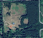
A quicker approach _might_ be to create a map of your property, as detailed as possible, using any resources (such as GoogleEarth, MyTopo, the library's copy machine... whatever) that you can get your hands on, then manually add the details you are interested in. Your margin of error would need to be large, but that might still get you something usable for the next couple years.

A point to note: GPS altitude figures, at least what I've seen on appliances (eg. phones) in the consumer market, are completely worthless for micro-local use. Accurate to _maybe_ 300' +or-. That means that if you want to incorporate elevations into your planning, you need to get them from a very good topo of your area or generate them yourself. The MyTopo site provides good service and good product at a reasonable price, at least the last time I used them a few years ago. I'm sure there are others.

Lasers from the box stores can give you 1/8" accuracy at 100 yds for $150 or so and I believe some will work at 1000 yards with a receiver to aim at. However, to use them at that distance requires mounting the laser on something that will let you sight it in like a rifle and you need to place a light-colored target at the point you wish to measure to. A second person at the target with voice connection (phone or radio) is almost necessary because the person aiming the laser cannot tell when they're on target - they can't see that far. But using a laser distance tool with a surveyor's transit and a _good_ compass will let you map your own property quite well.

However. Large amounts of time and some hundreds of $$$ are needed to feed this project. So seat of the pants approximation may actually start to look pretty good.

Last thought. Dig out what title and permit records are available for your property. Somebody probably had it surveyed at some point and that might give you a good starting point. I found a platte from 65 years ago for one of my sister's properties and used it to meet permitting requirements last year.

Regards,
Rufus
 
Posts: 672
Location: St. George, UT. Zone 8a Dry/arid. 8" of rain in a good year.
207
trees bike greening the desert
  • Likes 1
  • Mark post as helpful
  • send pies
    Number of slices to send:
    Optional 'thank-you' note:
  • Quote
  • Report post to moderator
I am not familiar with those other mapping apps mentioned, but they sound equal to or better than the one I use to track my outdoor activities.

It's called strava.com, and it's mainly a fitness tracking app.  It creates a gps map of your movements, it will create "segments" of your choosing of any size that can be specifically named, pictures taken during the outing can be manually uploaded to the site, and they'll show up on the map.  It gives detailed elevation, distance, time, and speed readings.  It's FREE!  You can make all of your activities private so only you can see your activities/segments.  You can download your gpx files.  Probably even more can be done with it, but that's mainly what I use.

It's super easy to use.  Any kind of gps that's capable of uploading a file (I've only ever used my cell phone) will work with it I believe.

If nothing else, it's a good app for anyone who likes to track their movements wherever they may be.  Also allows a person to look for local trails on the explore section.  You can also connect with other people and see their activities (but again, everything can be made private if you don't want it publicly available.)

Not sure if it's what you're looking for though.
 
Matt Leger
pollinator
Posts: 165
Location: St. Andrews West, Ontario, Canada (Zone 5b)
43
hugelkultur forest garden trees foraging medical herbs homestead
  • Mark post as helpful
  • send pies
    Number of slices to send:
    Optional 'thank-you' note:
  • Quote
  • Report post to moderator
Thank you both for the thorough replies and helpful information. There must be a lot of these apps out there because I have tried quite a few but I have never heard of any of the ones you guys mentioned. I will certainly try them all out though and report back with whichever works best for my specific application (in case anyone else here ever has a similar need). Thanks again!
 
Posts: 60
10
  • Likes 1
  • Mark post as helpful
  • send pies
    Number of slices to send:
    Optional 'thank-you' note:
  • Quote
  • Report post to moderator
What you need is a total station.  You don't need a high end one either for this.  Many surveying shops will rent these and an experienced surveyor could make a map of every tree in a couple days.  A scanner would even be quicker.  Also drones are pretty common that do this with photogrammetry.  Check out your local survey shop and you could probably get someone to do it pretty cheap and under the table.  
 
gardener & hugelmaster
Posts: 3730
Location: Gulf of Mexico cajun zone 8
1999
cattle hugelkultur cat dog trees hunting chicken bee woodworking homestead ungarbage
  • Likes 2
  • Mark post as helpful
  • send pies
    Number of slices to send:
    Optional 'thank-you' note:
  • Quote
  • Report post to moderator
I use the "drop breadcrumbs while hiking" feature of a handheld gps receiver to make a track file. Then import that into Google Earth. I have found cell phones to be considerably less accurate than actual gps for accurate mapping.

There are many .gpx file editors & similar tools available online.
 
Matt Leger
pollinator
Posts: 165
Location: St. Andrews West, Ontario, Canada (Zone 5b)
43
hugelkultur forest garden trees foraging medical herbs homestead
  • Mark post as helpful
  • send pies
    Number of slices to send:
    Optional 'thank-you' note:
  • Quote
  • Report post to moderator
Adding those to the list. I will be testing today and tomorrow so stay tuned for the results. Thank you!! :)
 
Posts: 735
Location: Morocco
101
cat forest garden trees solar wood heat woodworking
  • Likes 1
  • Mark post as helpful
  • send pies
    Number of slices to send:
    Optional 'thank-you' note:
  • Quote
  • Report post to moderator

Mike Barkley wrote:I have found cell phones to be considerably less accurate than actual gps for accurate mapping.  


Yes! I have an USB GPS+GLONAS+Gallileo+Baudu reciever. It is ready in less than 5 seconds from pluggin it in and usually has a <2m accuracy. Elevation is about 10m accurate.
 
Rufus Laggren
pollinator
Posts: 1234
Location: Chicago/San Francisco
196
  • Mark post as helpful
  • send pies
    Number of slices to send:
    Optional 'thank-you' note:
  • Quote
  • Report post to moderator
Sebastian, can you link to specs on that receiver or similar ones? I am looking in desultory fashion for something that will provide very good accuracy, particularly elevation, but so far I haven't noticed anything w/in my price range that looks worth considering.

Thanks,
Rufus
 
Sebastian Köln
Posts: 735
Location: Morocco
101
cat forest garden trees solar wood heat woodworking
  • Likes 1
  • Mark post as helpful
  • send pies
    Number of slices to send:
    Optional 'thank-you' note:
  • Quote
  • Report post to moderator
Rufus, the receiver is called GM-3N 300RU. I can't confirm the 10Hz resolution, but it certainly works at 1Hz (which is plenty for me).
If you want to do mapping with high accuracy, you need a differential receiver. Essentially two receivers. One is placed at a known stationary location and the measured locations is recorded. The second one is used for mapping, but also records all data.
As the first one is stationary, you know that it's location has not changed. That allows to compute the error over time and then that error can be subtracted from the second set of data. This will not work when any receiver does not see the full sky, as they will get different errors each.
 
Goodbye moon men. Hello tiny ad:
Willow Feeder movie
https://permies.com/t/273181/Willow-Feeder-movie
reply
    Bookmark Topic Watch Topic
  • New Topic