|

|
|
|
|

|
|

|

|

|


![[Thumbnail for 1.5ft-contourslope.png]](/t/48197/a/29442/1.5ft-contourslope.png "Filename: 1.5ft-contourslope.png
Description:")
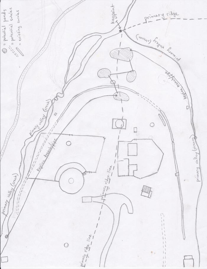
Kris Arbanas wrote:I am having trouble locating the/a keypoint on my property. Any thoughts?


Permaculture and Homestead Blogging on the Traditional Catholic Homestead in Idaho! Jump to popular topics here: Propagating Morels!, Continuous Brew Kombucha!, and The Perfect Homestead Cow!
![[Thumbnail for 1.5ft-contourslopemark.jpg]](/t/48197/a/29460/1.5ft-contourslopemark.jpg "Filename: 1.5ft-contourslopemark.jpg
Description:")
Permaculture and Homestead Blogging on the Traditional Catholic Homestead in Idaho! Jump to popular topics here: Propagating Morels!, Continuous Brew Kombucha!, and The Perfect Homestead Cow!
![[Thumbnail for contournew.png]](/t/48197/a/29462/contournew.png "Filename: contournew.png
Description:")
![[Thumbnail for contournew.png]](/t/48197/a/29463/contournew.png "Filename: contournew.png
Description:")
Permaculture and Homestead Blogging on the Traditional Catholic Homestead in Idaho! Jump to popular topics here: Propagating Morels!, Continuous Brew Kombucha!, and The Perfect Homestead Cow!
Dave Dahlsrud wrote: How 'bout a pond in that upper right quad near where the yellow contour line meets the road, you could do a 1% sloped swale from the upper left quad all the way across the property to feed the pond and increase the catchment for that pond.
Permaculture and Homestead Blogging on the Traditional Catholic Homestead in Idaho! Jump to popular topics here: Propagating Morels!, Continuous Brew Kombucha!, and The Perfect Homestead Cow!
 3
3
Regrarians Ltd.
www.Regrarians.org
Darren J Doherty wrote:G'day,
I saw this map before when my colleague Georgi Pavlov (www.HumaDesign.org) shared it with me asking my opinion.
Its seems clear to me that this particular contour map is a classic case of where the methods of extracting/making contours from GoogleEarth/Maps just doesn't work...they are inherently unreliable — you are much better off either getting a survey done or using the available county/state/federal photogrammetry or Lidar based data where possible.
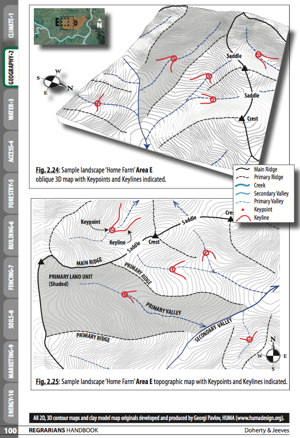
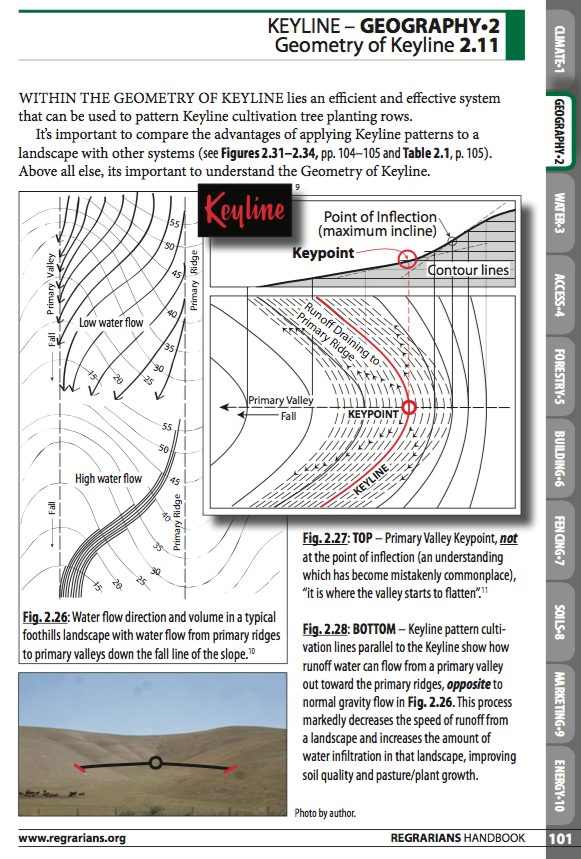
Regarding locating the Keypoint – I can save a bit of time here by pasting in a few extracts from the recently released 2. Geography chapter of the Regrarians eHandbook.
Thanks,
Darren J. Doherty
'I'd love to see some photos of this landscape cos it had so many anomalies!'
Regrarians Ltd.
www.Regrarians.org


10 humans raise one child https://www.kickstarter.com/projects/positiverealfutures/an-actually-fun-tv-show-about-a-future-with-real-hope

Skill verified by jordan barton")

Skill verified by Mike Barkley")

|
If you have a bad day in October, have a slice of banana cream pie. And this tiny ad:
Escape to gardens and natural buildings (for free-ish) in Montana
https://wheaton-labs.com/bootcamp
|