• Post Reply Bookmark Topic Watch Topic
  • New Topic
permaculture forums growies critters building homesteading energy monies kitchen purity ungarbage community wilderness fiber arts art permaculture artisans regional education skip experiences global resources cider press projects digital market permies.com pie forums private forums all forums
this forum made possible by our volunteer staff, including ...
master stewards:
  • Carla Burke
  • Nancy Reading
  • John F Dean
  • r ranson
  • Jay Angler
  • paul wheaton
stewards:
  • Pearl Sutton
  • Leigh Tate
  • Devaka Cooray
master gardeners:
  • Christopher Weeks
  • Timothy Norton
gardeners:
  • thomas rubino
  • Matt McSpadden
  • Jeremy VanGelder

How to transport a contour line on a map onto the land and viceversa?

 
pollinator
Posts: 195
Location: Spain
17
forest garden fungi urban
  • Likes 1
  • Mark post as helpful
  • send pies
    Number of slices to send:
    Optional 'thank-you' note:
  • Quote
  • Report post to moderator
Hi,
I'm not sure if this is the right forum to ask this question. If not please redirect me where it is appropriate.

Immagine you have a beautiful contour map of your property and you want to mark those contours on the ground. How do you go about it?
Would it be just enough to position yourself on the land with an altimeter, find the altitude where the mapped contour lines start (the highest one for example)  and just start marking
with whatever technology you have available? (A-frame, laser level,, etc.)
What if you don't have access to an altimeter (in some developing countries this may well be the situation)?
Can you just measure the distance, on the map, from a boundary of the property to the highes contour line and start from there for example, doing the same on the ground?

On the other hand, if you start by first marking those contour lines on the ground, how do you then plot them on a map (or google maps aerial photo)
if you don't have high tech equipment? I guess the same system, as mentioned above could be used as well, but reversing the measurements (contour line to boundary on the ground
and then do the same on to the map).
 
pollinator
Posts: 3859
Location: Kent, UK - Zone 8
705
books composting toilet bee rocket stoves wood heat homestead
  • Likes 6
  • Mark post as helpful
  • send pies
    Number of slices to send:
    Optional 'thank-you' note:
  • Quote
  • Report post to moderator
The contour lines on maps are rarely a perfect reflection of what is on the ground - they don't do a good job of identifying the small scale complexity of the shape of the ground.

Given that most applications that require knowing lines of equal altitude on the ground care an awful lot about that fine detail, I think attempting what you describe is likely to be counter-productive. For example, swale need to be dug on the level, so that water doesn't flow. Attempting to follow a path that is level on the map, but not on the ground, is likely to lead to flow and possible blow-out of swale berms at low points.

You don't say what you intend to use these lines for, but in any case I think it likely that you would be best off using tools to mark out what is actually on the ground.

There are threads here somewhere that explain various approaches to this.
 
author & steward
Posts: 7159
Location: Cache Valley, zone 4b, Irrigated, 9" rain in badlands.
3350
  • Likes 3
  • Mark post as helpful
  • send pies
    Number of slices to send:
    Optional 'thank-you' note:
  • Quote
  • Report post to moderator
I build swales in the actual dirt... Then a few years later, they show up on satellite images.

I can walk the swales with GPS active, then plot the GPS tracks on satellite images.
 
pollinator
Posts: 351
Location: Basque Country, Spain-43N lat-Köppen Cfb-Zone8b-1035mm/41" rain: 118mm/5" Dec., 48mm/2" July
143
3
purity personal care books cooking food preservation writing
  • Likes 3
  • Mark post as helpful
  • send pies
    Number of slices to send:
    Optional 'thank-you' note:
  • Quote
  • Report post to moderator
I think contour maps and staking things out on the ground serve different purposes and it's best to let each do its work independently.

Contour maps are good for laying things out, making a design (at your desk) of a property you may not know very well, or understanding more clearly what's going on at and around a property you are familiar with. And you can pencil out some ideas that later inform how you look at the property when you visit. Being super-precise is not usually what you're after, though I absolutely love 0.25m contour lines, I find it gives me an almost spiritual connection with the land.

Of course, garbage in, garbage out, you need really good survey/LIDAR data to generate 1-foot contours. You don't say where in Spain you are, but you may have really good aerial survey data done by your Autonomous Community. Here in the Basque Country we have 1-meter-resolution LIDAR surveys of the whole country, every inch. That's great to work with and you can generate fairly accurate 0.25m contour lines from that. Or very accurate 1m contours. I don't know if you use map-making software at all, QGIS for instance is free but the learning curve can be steep.

Google Maps and Google Earth generally suck for planning anything at the level of an individual property. Sometimes you get contour lines running perpindicular to actual contour in spots if you zoom in at a particular place. I would look for LIDAR data or do a drone survey.

Staking things out on the ground I would only do in the spots where I intend to build something dead level -- a swale, a house pad, a body of water, a section of path or road... I would not waste time trying to get any of this to line up with a line on the map unless there was a good reason to. The map is much less accurate than what you do on the ground.

A nice low-tech tool for running out contours on the ground is the water level, I think the Australians call it a Bunyan level. You need a couple of identical 1.5- or 2-m sticks, a few meters of transparent tubing, water or tea, some zip ties, a ruler, a permanent marker, and a companion. Run each end of the tubing along a stick and zip tie it in place firmly but without blocking off flow inside the tube, don't put a zip tie right at the bottom. You want a length of tubing between the sticks that corresponds to how you are going to flag out the contour line - 1m, 2m, 3m, 5m..., your choice depending on the complexity of the terrain and your needs. Stand the sticks-with-tube up next to each other on a level surface. Fill the tube with water (or tea for visibility) up to about eye level on the sticks. Mark the water level (which will of course be identical) with the marker on each end of the tube. So now you can run out a contour line on the land. Set a stick on the ground and put a flag (thin metal stick with a colo(u)red flag on the end) in right there. Your companion goes out with the other stick (without spilling any water of course), and finds the place where the water goes exactly up to the marked line when she sets the stick on the ground like you. That is level. She puts a flag in the ground to mark the spot, and then you take your stick ahead of her to mark the next spot. And so on until you're done.

The water level also works to stake out something you're going to build with a certain fall, say a drainage ditch that you want to lose -1.5m evelation over 100m run. So every 2 meters it will lose 3 cm. In that case you make three marks on each side of the tube, one where the water is level, and the other two 1.5 cm higher and lower than that on the tube (so exactly 3 cm between the top and bottom marks). So you set the first stick and flag it, companion moves with the other stick out 2m and slightly down to the place where the water reaches the top mark. And for the first person the water level will have descended to the bottom mark. That's the 3cm-difference you want. Flag and then repeat as in the other example.

I love stuff like that, but of course you can be "modern" and get a laser level or a transit level or whatever you want, ha, ha...

Does any of this help?
 
pollinator
Posts: 564
120
  • Likes 3
  • Mark post as helpful
  • send pies
    Number of slices to send:
    Optional 'thank-you' note:
  • Quote
  • Report post to moderator
I have never used an altimeter and don't know the sensitivity of one.   Here is what I would recommend.  find a countour line that intersects or touches a known point on the property.  Perhaps it is a road or a fenceline.  Use the intersection of the contour line and the known spot as your starting point.  Using whatever technology you chose (A frame, bunyip line, laser level, altimeter...) mark this spot as ZERO.  Decide the interval you want.  +1 foot, 20 meters of elevation, etc...  Measure out horizontally left and right of your zero point, staking as you go.  Now you have a zero line contour flagged on the ground.  From your zero line it is simply a matter of measuring a set amount of drop or gain from this line to begin establishing one's next contour.  Work horizontally on level (contour) left and right and you have a second and a third.  

Of course you can also just pick any random spot on the property and use this technique.  Once you have  a zero line established at some point you will be able to find correlation with a mapped intersection of a contour line.  Then you can calibrate by measuring drop or rise to your zero line.  and add or subtract that number from the mapped elevation.  

"A frames" work well to stay on a level  contour.  A bunyip or laser level work well for up and down slope.  They will all give you good results is you take your time and work accurately.  I don't need to know if a my driveway at the road is at 2594 meters really.  I do want to know where the my contour interval is above and below that intersection and how that line moves through the terrain.  

Here is some information on using a simple bunyip.  These home made devices can find level from one room to another around corners and up and down stairs, as water seeks its own level.  One just has to take a minute or two to calibrate them.


Antonio Scotti
pollinator
Posts: 195
Location: Spain
17
forest garden fungi urban
  • Likes 2
  • Mark post as helpful
  • send pies
    Number of slices to send:
    Optional 'thank-you' note:
  • Quote
  • Report post to moderator
Hi Michael ,

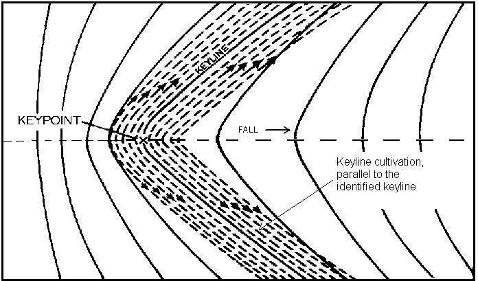
Michael Cox wrote:The contour lines on maps are rarely a perfect reflection of what is on the ground - they don't do a good job of identifying the small scale complexity of the shape of the ground.


Of course I totally agree with you here.

Michael Cox wrote:
Given that most applications that require knowing lines of equal altitude on the ground care an awful lot about that fine detail, I think attempting what you describe is likely to be counter-productive. For example, swale need to be dug on the level, so that water doesn't flow. Attempting to follow a path that is level on the map, but not on the ground, is likely to lead to flow and possible blow-out of swale berms at low points.


Ok, what I meant here was to use the map to have a reference point where to start marking, not that of following the line on the map as it is there.

Thanks
 
Antonio Scotti
pollinator
Posts: 195
Location: Spain
17
forest garden fungi urban
  • Mark post as helpful
  • send pies
    Number of slices to send:
    Optional 'thank-you' note:
  • Quote
  • Report post to moderator

Joseph Lofthouse wrote:I build swales in the actual dirt... Then a few years later, they show up on satellite images.

I can walk the swales with GPS active, then plot the GPS tracks on satellite images.


Indeed, just need to be patient!
 
Antonio Scotti
pollinator
Posts: 195
Location: Spain
17
forest garden fungi urban
  • Likes 3
  • Mark post as helpful
  • send pies
    Number of slices to send:
    Optional 'thank-you' note:
  • Quote
  • Report post to moderator
Hi Dave, thank you for your reply

Dave de Basque wrote:I think contour maps and staking things out on the ground serve different purposes and it's best to let each do its work independently.

Contour maps are good for laying things out, making a design (at your desk) of a property you may not know very well, or understanding more clearly what's going on at and around a property you are familiar with. And you can pencil out some ideas that later inform how you look at the property when you visit. Being super-precise is not usually what you're after, though I absolutely love 0.25m contour lines, I find it gives me an almost spiritual connection with the land.


Sure contout maps serve as you explain, I am aware of that.
But once you have a contour map, then you may want to design a swale system and after that you will want to do it for real by staking those contour lines you used to design the swale system, on the ground. That's what I am asking. It is the same concept as planting a tree after you have located it on a map, how do you find the tree position on the ground? (I can use triangulation for this if I have reference points on the ground that stand out also on the map)
I don't need precision here, only an approximate but clear starting point.
On the other hand, if I do the swale design directly on the ground (with whatever calculations aside, for runoff volumes etc.) how do I go back on paper if I want to document it with some accuracy (without a total station that is)? I know a hand-held GPS can be used but I understand that the error it gives is only acceptable over very large acreages.


Of course, garbage in, garbage out, you need really good survey/LIDAR data to generate 1-foot contours. You don't say where in Spain you are, but you may have really good aerial survey data done by your Autonomous Community. Here in the Basque Country we have 1-meter-resolution LIDAR surveys of the whole country, every inch. That's great to work with and you can generate fairly accurate 0.25m contour lines from that. Or very accurate 1m contours. I don't know if you use map-making software at all, QGIS for instance is free but the learning curve can be steep.


This work is not in Spain unfortunately, even Portugal doesn't seem to have accurate field data/maps, such as Lidar photos. But I am talking about a developing country, where they can barely access google maps.


Staking things out on the ground I would only do in the spots where I intend to build something dead level -- a swale, a house pad, a body of water, a section of path or road... I would not waste time trying to get any of this to line up with a line on the map unless there was a good reason to. The map is much less accurate than what you do on the ground.


Yes that's the idea. I didn't specify what I wanted to do, because I thought it wasn't necessary.


A nice low-tech tool for running out contours on the ground is the water level, I think the Australians call it a Bunyan level. You need a couple of identical 1.5- or 2-m sticks, a few meters of transparent tubing, water or tea, some zip ties, a ruler, a permanent marker, and a companion. Run each end of the tubing along a stick and zip tie it in place firmly but without blocking off flow inside the tube, don't put a zip tie right at the bottom. You want a length of tubing between the sticks that corresponds to how you are going to flag out the contour line - 1m, 2m, 3m, 5m..., your choice depending on the complexity of the terrain and your needs. Stand the sticks-with-tube up next to each other on a level surface. Fill the tube with water (or tea for visibility) up to about eye level on the sticks. Mark the water level (which will of course be identical) with the marker on each end of the tube. So now you can run out a contour line on the land. Set a stick on the ground and put a flag (thin metal stick with a colo(u)red flag on the end) in right there. Your companion goes out with the other stick (without spilling any water of course), and finds the place where the water goes exactly up to the marked line when she sets the stick on the ground like you. That is level. She puts a flag in the ground to mark the spot, and then you take your stick ahead of her to mark the next spot. And so on until you're done.

The water level also works to stake out something you're going to build with a certain fall, say a drainage ditch that you want to lose -1.5m evelation over 100m run. So every 2 meters it will lose 3 cm. In that case you make three marks on each side of the tube, one where the water is level, and the other two 1.5 cm higher and lower than that on the tube (so exactly 3 cm between the top and bottom marks). So you set the first stick and flag it, companion moves with the other stick out 2m and slightly down to the place where the water reaches the top mark. And for the first person the water level will have descended to the bottom mark. That's the 3cm-difference you want. Flag and then repeat as in the other example.

I love stuff like that, but of course you can be "modern" and get a laser level or a transit level or whatever you want, ha, ha...

Does any of this help?


Many thanks David for taking the time to explain all this.
Best regards
 
Antonio Scotti
pollinator
Posts: 195
Location: Spain
17
forest garden fungi urban
  • Likes 2
  • Mark post as helpful
  • send pies
    Number of slices to send:
    Optional 'thank-you' note:
  • Quote
  • Report post to moderator

Jack Edmondson wrote:I have never used an altimeter and don't know the sensitivity of one.   Here is what I would recommend.  find a countour line that intersects or touches a known point on the property.  Perhaps it is a road or a fenceline.  Use the intersection of the contour line and the known spot as your starting point.  Using whatever technology you chose (A frame, bunyip line, laser level, altimeter...) mark this spot as ZERO.  Decide the interval you want.  +1 foot, 20 meters of elevation, etc...  Measure out horizontally left and right of your zero point, staking as you go.  Now you have a zero line contour flagged on the ground.  From your zero line it is simply a matter of measuring a set amount of drop or gain from this line to begin establishing one's next contour.  Work horizontally on level (contour) left and right and you have a second and a third.  

Of course you can also just pick any random spot on the property and use this technique.  Once you have  a zero line established at some point you will be able to find correlation with a mapped intersection of a contour line.  Then you can calibrate by measuring drop or rise to your zero line.  and add or subtract that number from the mapped elevation.  


Hi Jack, thanks for suggesting that. It is probably the easiest way to go, provided that know point is visible on the map or aerial photo.
Thanks also for suggesting the video
Best regards
 
Dave de Basque
pollinator
Posts: 351
Location: Basque Country, Spain-43N lat-Köppen Cfb-Zone8b-1035mm/41" rain: 118mm/5" Dec., 48mm/2" July
143
3
purity personal care books cooking food preservation writing
  • Likes 2
  • Mark post as helpful
  • send pies
    Number of slices to send:
    Optional 'thank-you' note:
  • Quote
  • Report post to moderator

Jack Edmondson wrote:
Here is some information on using a simple bunyip.  These home made devices can find level from one room to another around corners and up and down stairs, as water seeks its own level.  One just has to take a minute or two to calibrate them.


Thanks, Jack, for your post and for digging up this video. It's "Bunyip," not "Bunyan" as I said from my scratchy memory above. And marking it in the way shown in your video is great and makes your Bunyip level useful in multiple projects over time.
 
The truth is rarely pure and never simple - Oscar Wilde
GAMCOD 2025: 200 square feet; Zero degrees F or colder; calories cheap and easy
https://permies.com/wiki/270034/GAMCOD-square-feet-degrees-colder
reply
    Bookmark Topic Watch Topic
  • New Topic