Hi everyone!
I've been interning/working in permaculture/agroforestry for 5 years now since getting my PDC, and am at a point where I really need to uplevel my mapmaking skills to be able to deliver better designs that show information effectively, in a professional looking manner.
The original method I was using was on-foot triangulation drawn onto a physically printed to-scale GIS map, which I then scanned and photoshopped. However, this is very time consuming and headache-inducing, and with higher demand for the mapmaking part of the design process than ever before, (I work with a small team designing and installing food forests, where this is one of my main roles, and we all still have other jobs to make ends meet financially) I'm assessing my options.
Action steps so far:
I purchased an iPad with which I've been able to cut down the design process time, by uploading topographical/satellite maps into the app Procreate and then using on-foot triangulation measurements to add in to-scale future trails, fruit tree & plant placements. This works relatively well, but is still kind of headachy and still isn't as professional looking or as detailed as I've seen other maps be. I attempted to use GIS tracks, an app for iPhone, to place trails & landmarks in a GPS map I can translate over to the property maps I'm using without having to physically pace out/measure, but the margin of error (5'+) is too high for the precise placements of fruit trees, trails etc. I dowloaded the app theodolite, which Ben Falk uses for surveying, but after watching several tutorials and still feeling pretty confused on how to actually apply this data to my admittedly amateur process, it was taking up a lot of space on my phone and I deleted the app.
Potential courses of action:
1. Learning ArcGIS cartography and using that for designs.
Does anyone here use the ArcGIS mapping software, and is it worth it? At this point I'm getting paid a few hundred dollars per map, and the software costs $500 a year, so that's something to consider that makes me somewhat hesitant. I also would need to learn how to use it, for which I found this free cartography course that starts in February:
https://www.esri.com/training/catalog/596e584bb826875993ba4ebf/cartography./
I feel somewhat resistant to learning even more new software, however, and wondering if it's worth it.
2. The other option I can see is to simply get better at doing it on foot, by ordering this section of the regrarians handbook that teaches more about cartography:
http://www.regrarians.org/product/regrarians-ehandbook-2-geography/
3. I could try both!
4. I could seek out a local land surveying company and approach them for an internship to try and learn better triangulation/surveying/software skills in person.
I'm so interested to hear opinions on what to do at this crossroads in my progress! Also, if you have any online resources teaching more about on-foot triangulation, I'd really really love to see them.
Thanks so much for your input,
J


 2
2


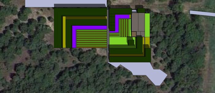
![[Thumbnail for 6E094586-56CC-4A07-82AD-1A183A47881E.png]](/t/153570/a/129081/6E094586-56CC-4A07-82AD-1A183A47881E.png "Filename: 6E094586-56CC-4A07-82AD-1A183A47881E.png
Description:")