|

|
|
|
|

|

|

|

|

|
 36
36


Permaculture will save civilization: http://www.human20project.com
Subtropical desert (Köppen: BWh)
Elevation: 1090 ft Annual rainfall: 7"
1
1
![[Thumbnail for jw-2.png]](/t/35897/a/16948/jw-2.png "Filename: jw-2.png
Description:")
![[Thumbnail for jw-1.png]](/t/35897/a/16949/jw-1.png "Filename: jw-1.png
Description:")
![[Thumbnail for jw-3.png]](/t/35897/a/16950/jw-3.png "Filename: jw-3.png
Description:") 1
1
Quintin

"If you will live like no one else, later you can live like no one else." -- Dave Ramsey
1
1
Permaculture will save civilization: http://www.human20project.com
2
Kelly in Northwest Vermont
Planting my retirement and my grandchildren-to-be's future on 10 acres of wooded land in my hometown of Jericho.
1
Permaculture will save civilization: http://www.human20project.com
Permaculture will save civilization: http://www.human20project.com
Manolis Karamous wrote:
For screenshot capturing program a nice one that works on Windoz,on Mac and on Linux as well is ScreenCloud
My project thread
Agriculture collects solar energy two-dimensionally; but silviculture collects it three dimensionally.
Permaculture will save civilization: http://www.human20project.com

Subtropical desert (Köppen: BWh)
Elevation: 1090 ft Annual rainfall: 7"
Cj Verde wrote:
Manolis Karamous wrote:
For screenshot capturing program a nice one that works on Windoz,on Mac and on Linux as well is ScreenCloud
Screen capture is a built in feature on a Mac, all you have to do is hit SHIFT, COMMAND, 3, all at the same time. It'll make a sound like an old fashioned camera taking a photo. Mine get saved to the desktop but if you can't find it, search for "screen shot."
1
3
Permaculture will save civilization: http://www.human20project.com
3
Permaculture will save civilization: http://www.human20project.com


 1
1
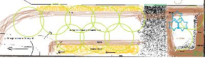
![[Thumbnail for tw-skp-contour-are-wrong.JPG]](/t/35897/a/18533/tw-skp-contour-are-wrong.JPG "Filename: tw-skp-contour-are-wrong.JPG
Description: sketchup screen shot") 1
1
Permaculture will save civilization: http://www.human20project.com
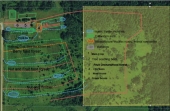
![[Thumbnail for dfwmapsdotcom-2ft-countours-sm.JPG]](/t/35897/a/18567/dfwmapsdotcom-2ft-countours-sm.JPG "Filename: dfwmapsdotcom-2ft-countours-sm.JPG
Description: 2foot contours over Bing ariel photo (dfwmaps.com)") 2
2
Permaculture will save civilization: http://www.human20project.com
1
Dave's SKIP BB's / Welcome to Permies! / Permaculture Resources / Dave's Boot Adventures & Longview Projects

Skill verified by gir bot")

Skill verified by Mike Haasl")

Skill verified by Mike Haasl")

Skill verified by Nicole Alderman")

Skill verified by Nicole Alderman") 1
1
Rick
Those who hammer their swords into plows will plow for those who don't!
Come join me at www.peacockorchard.com
1
1
Lina
https://catsandcardamom.com
1
sK1 is an open source multiplatform vector graphics editor similar to CorelDRAW, Adobe Illustrator, or Freehand. The major feature of sK1 is a professional precise printing and "prepress ready" PDF & PostScript output.
If I am not for myself, who will be for me?
If I am only for myself, what am I?
If not now, when?

|
I wasn't selected to go to mars. This tiny ad got in ahead of me:
Workee-job sucks? Quit and live the permaculture way in Montana
https://wheaton-labs.com/bootcamp
|