gift
100th Issue of Permaculture Magazine
will be released to subscribers in: soon!

  • Post Reply Bookmark Topic Watch Topic
  • New Topic
permaculture forums growies critters building homesteading energy monies kitchen purity ungarbage community wilderness fiber arts art permaculture artisans regional education skip experiences global resources cider press projects digital market permies.com pie forums private forums all forums
this forum made possible by our volunteer staff, including ...
master stewards:
  • paul wheaton
  • Anne Miller
  • Carla Burke
  • Nancy Reading
  • John F Dean
  • Timothy Norton
  • Jay Angler
stewards:
  • r ransom
  • Pearl Sutton
  • Tereza Okava
master gardeners:
  • Christopher Weeks
gardeners:
  • M Ljin
  • Megan Palmer
  • Kate Downham

How much elevation change do you deal with?

 
master gardener
Posts: 7080
Location: Carlton County, Minnesota, USA: 3b; Dfb; sandy loam; in the woods
4527
8
forest garden trees books chicken food preservation cooking fiber arts seed woodworking homestead ungarbage
  • Likes 8
  • Mark post as helpful
  • send pies
    Number of slices to send:
    Optional 'thank-you' note:
  • Quote
  • Report post to moderator
A lot of the most visible stuff here is Paul's mountain property. But that's really different topography than what I deal with. I decided to check it out on the county's GIS platform. The highest contour on my 20 acres is 1266' and the lowest is 1242. That shows a difference of 24' but most of the parcel is within six feet of 1254'. And the only place that you can't just casually walk is near the south west corner where the road was elevated quite a ways above the natural level of the property.

That said, there's no area that you would call flat -- there's a rolling change everywhere you look. And for instance, if I want to put in a hightunnel, recommendation is that it be flat...how flat? if one end of a 50' tunnel is two feet higher than the other end does that matter? If I had clay, I'd wonder how much "rise over run" there needs to be to consider terracing.

So what's your situation? I'm curious what counts as flat vs not.
 
out to pasture
Posts: 13492
Location: Portugal
4754
goat dog duck forest garden foraging wofati composting toilet bee solar rocket stoves greening the desert
  • Likes 13
  • Mark post as helpful
  • send pies
    Number of slices to send:
    Optional 'thank-you' note:
  • Quote
  • Report post to moderator
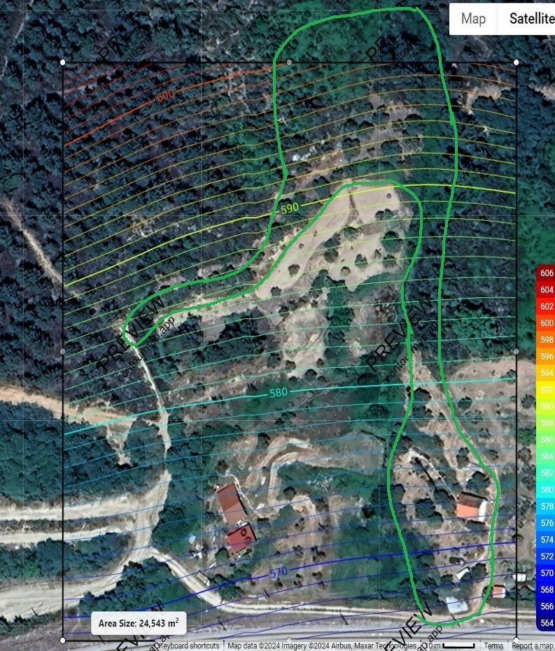
We have a very weirdly laid out bit of land.

It's two and half acres, 200 metres from the bottom to the top, with nearly 50 metres of elevation change.

It's an interesting couple of acres!

As to what counts as flat, most of our land is terraced, so there are lots of 'flat' bits. Very flat in fact. But moving up to the next terrace is hard work!
contour-outline-map.jpg
[Thumbnail for contour-outline-map.jpg]
 
pollinator
Posts: 670
119
  • Likes 5
  • Mark post as helpful
  • send pies
    Number of slices to send:
    Optional 'thank-you' note:
  • Quote
  • Report post to moderator
Zounds, yall have an amazing property there Burra!  Now I see how wood gathering for your RMH is not a far flung enterprise.  
 
master steward
Posts: 19868
Location: USDA Zone 8a
4981
dog hunting food preservation cooking bee greening the desert
  • Likes 7
  • Mark post as helpful
  • send pies
    Number of slices to send:
    Optional 'thank-you' note:
  • Quote
  • Report post to moderator
I live on top of a mountain though my house is much lower than my front gate.

Actually my house is about mid point and the back of my property is the lowest.

My property has a runway where planes used to land, my guess would be in the 1940s though I have no idea.  So that part of my property is flat.

The creek that runs in front of my house was changed due to that runway as now it goes nowhere.  It probably originally connected to another creek that goes nowhere.

Observing what water does when it rains is really interesting because it mostly follows my winding road.
 
Posts: 26
Location: Beautiful Ozarks of Missouri
16
cat trees woodworking
  • Likes 9
  • Mark post as helpful
  • send pies
    Number of slices to send:
    Optional 'thank-you' note:
  • Quote
  • Report post to moderator
This map site shows shaded contours that really stand out. It's very useful for me, I hope it's useful to others as well. The view can be changed with the settings on the right.
This is Current River in Missouri, but you can zoom out, scroll to your property, and zoom in.
https://caltopo.com/map.html#ll=36.98001,-90.99006&z=16&b=imagery&o=r&n=1

As far as my 19 acres goes....(all figures are approximate. Used Google Earth to measure)
4 acres cleared flat areas, including sections of new and old driveways.
9 acres of gently sloped, and flat woods
6 acres of steep hilly wooded areas.

A straight line from my house to the driveway entrance measures 755 ft.
Because of the hilly terrain, the winding driveway measures 1200 ft.
The house sits roughly 125 ft above the driveway entrance.

Edit to add...the highest point on the property is 60 ft above where the house sits. A house was at that high point until the federal govt. purchased a portion of the property for a project in the late 80's.


master steward
Posts: 16423
Location: Pacific Wet Coast
10946
duck books chicken cooking food preservation ungarbage
  • Likes 9
  • Mark post as helpful
  • send pies
    Number of slices to send:
    Optional 'thank-you' note:
  • Quote
  • Report post to moderator
Our property is a rather unique shape with a total elevation change of 14.5 meters (about 47 ft). The bigger issue is that although overall, it's a south facing slope, we have near the peak elevation halfway up, then down to a flat "flood plain" with a seasonal creek, then another steep section.

So I really notice the steep sections if I'm having to push loads up in Big Green, and occasionally have to be careful that Big Green doesn't pull me down one of the hills, which is steeper than most people give it credit for.
 
master steward
Posts: 8982
Location: southern Illinois, USA
3899
goat cat dog chicken composting toilet food preservation pig solar wood heat homestead composting
  • Likes 5
  • Mark post as helpful
  • send pies
    Number of slices to send:
    Optional 'thank-you' note:
  • Quote
  • Report post to moderator
I am on the east side of a hill.  My 11 acres has an 80 ft variation.  This is skewed data because I have a creek bed that has eroded about 10 ft or more in spots. I do have a flat garden  area.   I also have a gently  sloping pasture on the extreme east side of the property.  The huge plus is that tornados tend to pass over my house and barn (guess how many times I had to stop auto-corrupt from entering Passover

Edit:  I took the time to check. My property drops 60 feet from the NW to the SE. This does not include the eroded creek.
 
gardener
Posts: 863
Location: Semi-nomadic, main place coastal mid-Norway, latitude 64 north
607
  • Likes 12
  • Mark post as helpful
  • send pies
    Number of slices to send:
    Optional 'thank-you' note:
  • Quote
  • Report post to moderator
Our piece of land is a narrow-ish strip, roughly 1,200m long, running more or less in a north-south direction. The lowest point (lake shore, southern end) is about 18m above sea level. The highest point (above the treeline, nearly to the top of the mountain ridge) is at 300m above sea level. So yeah, quite steep. Not an uniform slope by any means, some patches are flatter, though calling any of it "flat" would be lying. (I'm reminded of that thing from one of Terry Pratchett's books: "The only flat places are the tops of tables and some people's heads.") The steepest parts I wouldn't want to try climbing without a tether.

There are upsides and downsides to the slope (pun sort of intended). Since it's south facing, I imagine it improves the microclimate quite a bit. Also, it ensures that our copious amounts of rain water drain away without issues. On the downside, building things is a hassle even on the flattest patches, and of course transporting things up-slope is heavy.
 
Jay Angler
master steward
Posts: 16423
Location: Pacific Wet Coast
10946
duck books chicken cooking food preservation ungarbage
  • Likes 8
  • Mark post as helpful
  • send pies
    Number of slices to send:
    Optional 'thank-you' note:
  • Quote
  • Report post to moderator

Eino Kenttä wrote:... (I'm reminded of that thing from one of Terry Pratchett's books: "The only flat places are the tops of tables and some people's heads.")


It sounds to me that the Terry Pratchett quote you're really looking for is, "There's lots of flat land... only it's vertical."
 
steward and tree herder
Posts: 14839
Location: Isle of Skye, Scotland. Nearly 70 inches rain a year
8472
6
transportation dog forest garden foraging trees books food preservation woodworking wood heat rocket stoves ungarbage
  • Likes 12
  • Mark post as helpful
  • send pies
    Number of slices to send:
    Optional 'thank-you' note:
  • Quote
  • Report post to moderator
Interesting question Christopher.

My property faces roughly East and slopes from the road just above the house, down to the river at the valley bottom. I did a quick check on google maps and it looks like I have roughly 40m change in elevation over just over 300m. Google maps show it as a gradual change, but the terrain here is actually slightly stepped due to the way the rock solidified from lava with different hardnesses in layers, so there are slightly steeper and slightly shallower bits of slope. I'm always either going up or downhill which can make jobs much harder or easier depending on what I need to carry. Today it was carrying rocks downhill, which is much easier than the reverse! All my coppice wood is downhill from the house, so I season the wood in shelters in the woodland, so that it is less heavy when I bring it up to the woodshed for dry storage near the house.

As regards polytunnels, my previous polytunnel was sloped up/down the slope with at least 3ft difference (over about 42 ft). It makes putting the cover on slighly awkward to get it tensioned well, but I always felt that there was a slight thermal draught through that helped keep it ventilated. My new tunnel is sloped side to side again about 3 or 4 feet, which is much more tricky and I wouldn't recommend it in retrospect. It does have the possible advantage of being slightly earth sheltered now, like a chinese greenhouse. This may be an advantage in colder weather, we'll see as my first winter approaches.
 
pollinator
Posts: 537
Location: UK
188
kids urban seed
  • Likes 9
  • Mark post as helpful
  • send pies
    Number of slices to send:
    Optional 'thank-you' note:
  • Quote
  • Report post to moderator
Mine is pretty much flat, maybe 8-10ft of change over the whole plot. The one sloped corner has ended up being the best spot for anything that hates sitting in water though. Garlic, onions, and my stone fruit all do noticeably better there after wet winters.
 
pollinator
Posts: 139
Location: Half acre on a hill in Central Alabama, Zone 8a and 8b
135
hugelkultur art forest garden fungi foraging food preservation cooking writing composting
  • Likes 10
  • Mark post as helpful
  • send pies
    Number of slices to send:
    Optional 'thank-you' note:
  • Quote
  • Report post to moderator
Ours is an east-facing half acre sub-rural lot rising roughly 3 meters from street to hilltop. The front yard is the 'flat' part, rising quickly from the curb, then gently toward the house at around a three feet (1m) total. Behind the house the terrain angles more noticeably, climbing 6-8 ft (2+ m) before falling off vertically into the neighboring property.  It's a little lumpy, but it's easier to think of as a uniform west-to-east downhill gradient, with a slight northern tilt, which is important only in that my neighbor's yard sheds a great deal of water onto the front lawn.

The soil is native red clay, which made for rapid disposal of rainfall, and extremely dry conditions between showers. The front lawn was also host to a long-abandoned driveway composed of compacted layers of limestone gravel and river rock. I've since removed the rock and built a line of 8x8' growing spaces with hugel trenches in each, which now catch much of the neighbor's runoff.

Elsewhere there was (and mostly still is) a uniform layer of lawn grass, sitting just an inch or two above solid clay. We used to watch the rain run off in sheets on its way to the street, so I looked for ways to capture that resource. Besides the driveway garden line, we also planted fruit and nut trees in front. In the backyard I added terraces along one side and dug 2 ft deep trenches across the lawn, perpendicular to drainage flow, and backfilled them with organic material. The additional rainwater capture wasn't enough to prevent significant losses from our usual summer drought, but the difference between this year and our first year here were truly dramatic.

We do plan to scrape the top of the hill flat to build a new art studio with a rainwater catchment system and a greenhouse on one end.
 
pioneer
Posts: 304
Location: Wisconsin Zone 5a
134
cat forest garden chicken building medical herbs wood heat
  • Likes 9
  • Mark post as helpful
  • send pies
    Number of slices to send:
    Optional 'thank-you' note:
  • Quote
  • Report post to moderator
My property is considered flat. We just took the laser transit to the property and one side is 2 1/2 feet lower than the other
 
pollinator
Posts: 1008
Location: 10 miles NW of Helena Montana
588
hugelkultur chicken seed homestead
  • Likes 9
  • Mark post as helpful
  • send pies
    Number of slices to send:
    Optional 'thank-you' note:
  • Quote
  • Report post to moderator
I have 10 acres that is 2 wide and 5 long.  The 2 wide starts at the road and climbs the mtn.   Just under 250 foot elevation gain.
The only flat areas are what we have created, though the lower couple acres by the road are only 10 to 15 foot elevation gain from the road then it gets a bit steeper.  I have a couple walking trails that zig zag through the woods going up.  (I let one of my sons build an off grid home towards the top of the property, what a view he has).
My Dad was able to visit a few years ago and he told me my land was pretty much flat, just not horizontally flat.  That sounds like that  Terry Pratchett knew what was what.
(Ok, going down the google rabbit hole now, gotta learn about this Terry Pratchett person).
 
Posts: 1
  • Likes 2
  • Mark post as helpful
  • send pies
    Number of slices to send:
    Optional 'thank-you' note:
  • Quote
  • Report post to moderator
From a civil engineering perspective & American Disabilities Act (ADA) 2% is considered flat.  

2% slope is for landings & change of direction, 8.33% for ramps with handrails. 4.99% for walkways without handrails. FHWA, AASHTO, USFS & WBDG has recommendations on road slopes, parking lots & airfields. You can also look at the International Building Code for slopes away from buildings, foundations. etc. The budget you have will inform you what the best solution for your development is. Terracing is one solution mentioned, retaining walls, split level building construction, etc. Drainage and soil type must be considered for global slope stability. Maintenance also has to be done and is key to prevent failures. USGS & GIS is helpful in getting approximate slopes but for construction detail plans get a good topographic survey, it will save you money later. Check with your local Authority Having Jurisdiction (AHJ) for zoning, setbacks, general soil type, frost depth, geological formation, hydrology, environmental constraints, landscaping, etc.
 
30 seconds to difuse a loaf of bread ... here, use this tiny ad:
Own 37 Acres in AZ - good water wells - 44% discount, only $22k!
https://permies.com/t/96159/Acre-site-Northwestern-AZ-sale
reply
    Bookmark Topic Watch Topic
  • New Topic