• Post Reply Bookmark Topic Watch Topic
  • New Topic
permaculture forums growies critters building homesteading energy monies kitchen purity ungarbage community wilderness fiber arts art permaculture artisans regional education skip experiences global resources cider press projects digital market permies.com pie forums private forums all forums
this forum made possible by our volunteer staff, including ...
master stewards:
  • Nancy Reading
  • Carla Burke
  • r ranson
  • John F Dean
  • paul wheaton
  • Pearl Sutton
stewards:
  • Jay Angler
  • Liv Smith
  • Leigh Tate
master gardeners:
  • Christopher Weeks
  • Timothy Norton
gardeners:
  • thomas rubino
  • Jeremy VanGelder
  • Maieshe Ljin

Love of old tech—MAPS!!

 
gardener
Posts: 5436
Location: Southern Illinois
1487
transportation cat dog fungi trees building writing rocket stoves woodworking
  • Likes 12
  • Mark post as helpful
  • send pies
    Number of slices to send:
    Optional 'thank-you' note:
  • Quote
  • Report post to moderator
I am teaching my youngest daughter to drive and something I want her to be able to do is read an actual paper map.  Don’t get me wrong, I like my GPS, it’s very useful and has really practical applications, but I find that relying on a GPS screen tends to blunt my spatial awareness of an area compared to using an old fashioned paper map.  I think that a map requires me to really think more about my surroundings and not just follow GPS directions.  And I want my daughter to be map literate as well.

I had to dig up an old treasure of mine, a state topographical atlas that I used to use for my old College days National Forest exploration adventures.  It is certainly old, and in some ways it is a bit outdated (some roads have changed), but it is good to hold in hand.  I still love my GPS and Google earth, but there is something about holding an old paper map that is special to me.  This is one piece of “old tech” that I hope we don’t lose to an easier option.

Now I need to find and learn how to use a sextant!

Eric
 
gardener
Posts: 1871
Location: Japan, zone 9a/b, annual rainfall 2550mm, avg temp 1.5-32 C
930
2
kids home care trees cooking bike woodworking ungarbage
  • Likes 14
  • Mark post as helpful
  • send pies
    Number of slices to send:
    Optional 'thank-you' note:
  • Quote
  • Report post to moderator
Maps are almost 1/4 of our wall decorations... They will be more if I ever get around to making frames for the two big antiquated world maps I have had rolled up in my office since I found them three years ago.

I like gazing at them while I'm thinking about something else. Or when I need focus. Or when they catch my eye. Or in the rare case where I actually want to see where something is.
 
Posts: 114
40
  • Likes 7
  • Mark post as helpful
  • send pies
    Number of slices to send:
    Optional 'thank-you' note:
  • Quote
  • Report post to moderator
If I’m taking a new trip, I always check the GPS directions against a map first, but I have to admit I’m biased because at one point I worked as a cartographer.

We decorate with maps too. On the walls, furniture and pillows.
 
pollinator
Posts: 1495
855
2
trees bike woodworking
  • Likes 9
  • Mark post as helpful
  • send pies
    Number of slices to send:
    Optional 'thank-you' note:
  • Quote
  • Report post to moderator
Great idea Eric.

I’m a map guy. It was a right of passage growing up - being the navigator! I don’t miss the lay-by shouting matches with my wife in pre GPS days. These days I mostly look at maps when I’m planning cycling somewhere I haven’t been before, looking for contours, something GPS nav and bike nav apps still gets wrong.
 
Eric Hanson
gardener
Posts: 5436
Location: Southern Illinois
1487
transportation cat dog fungi trees building writing rocket stoves woodworking
  • Likes 6
  • Mark post as helpful
  • send pies
    Number of slices to send:
    Optional 'thank-you' note:
  • Quote
  • Report post to moderator
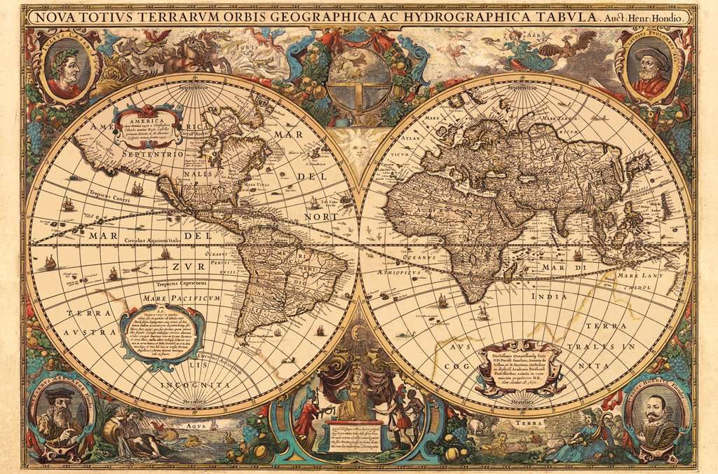
Decorating with maps!  Yes!!  I like this as well.  I especially like old maps as those were as much art as science.  In particular I like maps of the early days of exploration where cartographers didn’t know exactly where they were and tried to fill in the pieces as best as possible.  I remember one map being a very accurate portrayal of the eastern coast of America, but sort of grafted so as to make Mexico a part of India!  Those were obviously inaccurate maps, but what works of art and one can see just how difficult a job making those maps was for those early cartographers.

But even more modern maps can be real works of art and technical science all in one.

Maps are awesome!

Eric
 
Eric Hanson
gardener
Posts: 5436
Location: Southern Illinois
1487
transportation cat dog fungi trees building writing rocket stoves woodworking
  • Likes 6
  • Mark post as helpful
  • send pies
    Number of slices to send:
    Optional 'thank-you' note:
  • Quote
  • Report post to moderator
And yes, Edward, GPS rarely gets the contours of the ground accurate.  As much as I love Google Earth, I wish it came with a topographical overlay so I could easily see the elevation contours.

Sadly, the extensive use of GPS has meant that many either don’t know how to read a map or are just uncomfortable with it.  I hope (fingers crossed) that my daughter learns how to read a map, even if she doesn’t appreciate a map the way I do.

Eric
 
pollinator
Posts: 187
Location: Northern UK
87
  • Likes 8
  • Mark post as helpful
  • send pies
    Number of slices to send:
    Optional 'thank-you' note:
  • Quote
  • Report post to moderator
Another map lover here. We are due to move house soon (we hope) and have already bought the Ordnance Survey maps of the area. I keep looking at them to decide on the best dog walks to try. Way back when I was 12 years old, my dad discovered I could map read so from then on, for family holidays that was my job. Mum was hopeless at it, not being able to tell her left from her right so was happy to give it up. Interestingly, although it is said that "women can't read maps" my sister and I both can. When Mr Ara first had a satnav in his car he used to follow that rather than listening to me, even though I was the one who was correct.
 
steward & bricolagier
Posts: 14662
Location: SW Missouri
10093
2
goat cat fungi books chicken earthworks food preservation cooking building homestead ungarbage
  • Likes 7
  • Mark post as helpful
  • send pies
    Number of slices to send:
    Optional 'thank-you' note:
  • Quote
  • Report post to moderator
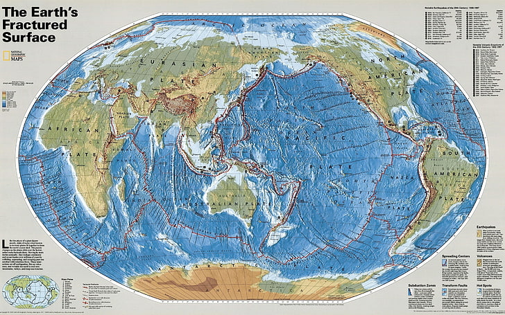
I had a house long ago that had a 30 foot long hallway with one wall that had no doors all the way down (it was an addition.) I put up maps from National Geographic all the way down the hall, floor to ceiling. It was fascinating to walk the hall! I miss my maps.
I had my favorite right in front of my bedroom door, the map of the fault and fracture lines of the planet.


At this house we have on the wall a puzzle we did that we framed in glass


And I am firmly of the belief that using GPS all of the time messes up a part of your brain that naturally maps where you are. Mental maps are how people have found their way around since before records were kept, and I think letting that part of the mind atrophy is not a good thing.
 
steward
Posts: 16058
Location: USDA Zone 8a
4272
dog hunting food preservation cooking bee greening the desert
  • Likes 4
  • Mark post as helpful
  • send pies
    Number of slices to send:
    Optional 'thank-you' note:
  • Quote
  • Report post to moderator
When we had our homestead we had a county map on the
wall.

One of the first things that we did when we bought our current property was to go to the local chamber of commerce and get a county map.

The maps they give out have a county map on one side and a city map on the other side.

Today we went to town to get the cat a rabies shot.  We used the onboard navigational system map to guide us.

It was fun to see that the map had the street correct, even out here in the boondocks.

Eric, I feel teaching your daughter about maps is a great idea.
 
steward
Posts: 4837
Location: West Tennessee
2438
cattle cat purity fungi trees books chicken food preservation cooking building homestead
  • Likes 6
  • Mark post as helpful
  • send pies
    Number of slices to send:
    Optional 'thank-you' note:
  • Quote
  • Report post to moderator
I love maps as well. I also have a small map collection which serves as wall art. I like how many old cartographers made maps based on written accounts from explorers, and many contain what we might call errors now. Below is one of my older maps from 1699 showing California as an island. What I really like about this one is it shows a couple ships and a few sea monsters in the oceans.

North-America.jpeg
Map of North America
 
Rusticator
Posts: 8568
Location: Missouri Ozarks
4542
6
personal care gear foraging hunting rabbit chicken cooking food preservation fiber arts medical herbs homestead
  • Likes 4
  • Mark post as helpful
  • send pies
    Number of slices to send:
    Optional 'thank-you' note:
  • Quote
  • Report post to moderator
Maps & globes!! Love 'em!! We have a couple of maps on the wall in the living/greatroom, near the fireplace - o one world & one USA, with red or black pins in all the places we've been, together, and white pins for the places we plan to go, in the next calender year. Unfortunately, the most recent white pins have been sitting there, in the same place(not replaced with red or black) since early 2020. I've also a stash of old maps from all over the place, in a box, waiting for me to get everything up on the walls - but I'm loathe to put too many nail holes in the logs, so....

As far as gps... it's handy, and on the motorcycle, especially so. But, I used to be a truck driver, and I was my dad's navigator,  as a kid - starting as soon as I could read, so I've a very real soft spot for paper maps, and collect them from all the places we go, where they're available. Living in a rather popular tourist spot, there are fun little local tourist-trap maps, too.

When I was homeschooling my kids, I used them as a teaching tool, making my kids the navigators, but I'm not sure any of it stuck with them. But, maps have SO MUCH to contribute to a good education, at any age! From colors and shapes, to math, time, history, weather/climate, reading, and science, to the obvious geography,  and even art... They're one of my favorite tools for teaching and life.
 
master steward
Posts: 6968
Location: southern Illinois, USA
2536
goat cat dog chicken composting toilet food preservation pig bee solar wood heat homestead
  • Likes 3
  • Mark post as helpful
  • send pies
    Number of slices to send:
    Optional 'thank-you' note:
  • Quote
  • Report post to moderator
Like others here, I keep a collection of maps.  I have a road atlas in both of my vehicles.  Yes, I have GPS, but more than once, the GPS has been wrong.  We have a couple of 1 way streets in our town that cars regularly go the wrong way on. They have been 1 way for over 50 years.  But my GPS directs me  to drive the wrong way on them.
 
Eric Hanson
gardener
Posts: 5436
Location: Southern Illinois
1487
transportation cat dog fungi trees building writing rocket stoves woodworking
  • Likes 3
  • Mark post as helpful
  • send pies
    Number of slices to send:
    Optional 'thank-you' note:
  • Quote
  • Report post to moderator
James, I love that old map of North America before its coasts were fully discovered.  Obviously the Gulf of California had been discovered so it was logical that it continued all the way up the continent.  It shows just how much imagination went in to making some of those make that were made with incomplete information.

Eric
 
Eric Hanson
gardener
Posts: 5436
Location: Southern Illinois
1487
transportation cat dog fungi trees building writing rocket stoves woodworking
  • Likes 6
  • Mark post as helpful
  • send pies
    Number of slices to send:
    Optional 'thank-you' note:
  • Quote
  • Report post to moderator
On the notion of maps, I remember a map from about 30 years ago that was one of the most unusual one that I have ever seen.  It tried to get around the issue of curvature distortion and Mercator Scale projection by displaying the whole Earth in three overlapping images.  This map allowed one to chart a route to just about any place on earth without having the usual problems with oversized objects near the poles.  I don't know what the name was but I was wondering if anyone knew of the map I was thinking of?  

On a slightly different note, the same cartographer made a similar map, but instead of focusing on political boundaries, it focused on hydrological features, especially rivers and streams.  I never saw this, but as I understand, it gave great contour relief as the rivers basically traced the contours of the various continents.  Again, this is a map I would love to see.

Does anyone know about these maps or this cartographer?

Eric
 
Posts: 1
1
  • Likes 6
  • Mark post as helpful
  • send pies
    Number of slices to send:
    Optional 'thank-you' note:
  • Quote
  • Report post to moderator
A decent medium that I've found is openstreetmap, apps like OSMAnd get you some functionality of gps, but it feels a lot more map-like than an actual gps or google maps or what have you. Bonus for it being open source, volunteer made, and offline too!  
Generally speaking, it's better than google maps in rural areas since google doesn't give them the same attention as urban areas
 
John F Dean
master steward
Posts: 6968
Location: southern Illinois, USA
2536
goat cat dog chicken composting toilet food preservation pig bee solar wood heat homestead
  • Likes 2
  • Mark post as helpful
  • send pies
    Number of slices to send:
    Optional 'thank-you' note:
  • Quote
  • Report post to moderator
Hi Steve,

Welcome to Permies.
 
gardener
Posts: 1208
Location: Proebstel, Washington, USDA Zone 6B
691
2
wheelbarrows and trailers kids trees earthworks woodworking
  • Likes 4
  • Mark post as helpful
  • send pies
    Number of slices to send:
    Optional 'thank-you' note:
  • Quote
  • Report post to moderator

steve wil wrote:A decent medium that I've found is openstreetmap, apps like OSMAnd get you some functionality of gps, but it feels a lot more map-like than an actual gps or google maps or what have you. Bonus for it being open source, volunteer made, and offline too!  
Generally speaking, it's better than google maps in rural areas since google doesn't give them the same attention as urban areas


To get printed maps from Open Street Map I like to use Field Papers. Field Papers lets you create a PDF atlas. It is designed to let you make notes and draw lines on the maps, and then scan and upload it so that you can edit OSM. Or use it in other GIS programs with automatic georeferencing. So far I have just printed maps from it.
 
Anne Miller
steward
Posts: 16058
Location: USDA Zone 8a
4272
dog hunting food preservation cooking bee greening the desert
  • Likes 2
  • Mark post as helpful
  • send pies
    Number of slices to send:
    Optional 'thank-you' note:
  • Quote
  • Report post to moderator
When I am in a new area, I always go to the local Chamber of Commerce to get free maps of the area.

The last ones I got had the city on one side and the county on the other.

Also, the Chamber of Commerce can give folks things like free information, and stuff such as guidebooks and phone books.
 
Anne Miller
steward
Posts: 16058
Location: USDA Zone 8a
4272
dog hunting food preservation cooking bee greening the desert
  • Likes 4
  • Mark post as helpful
  • send pies
    Number of slices to send:
    Optional 'thank-you' note:
  • Quote
  • Report post to moderator
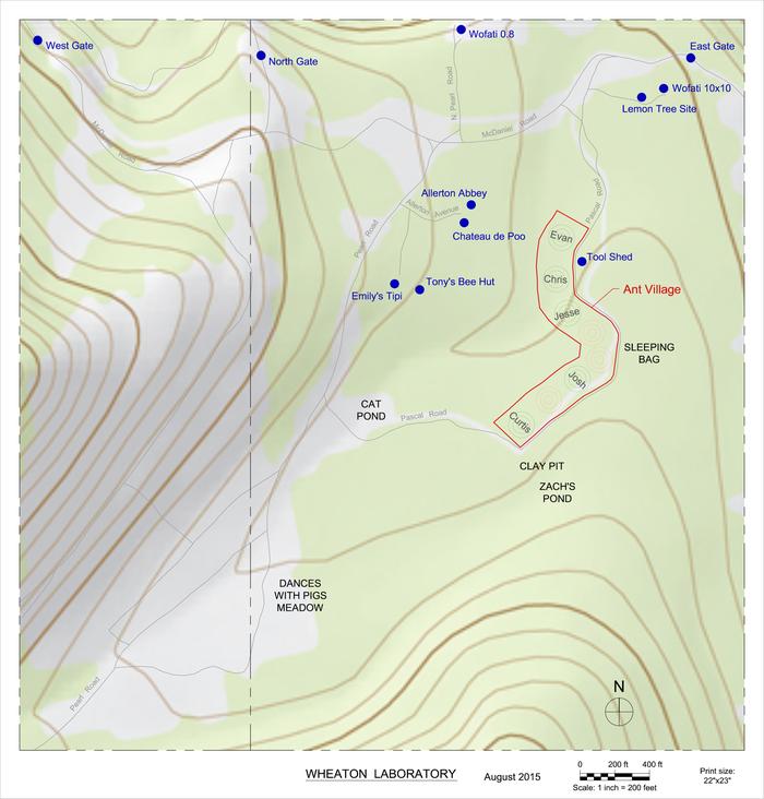
For fun, I thought I would post some of the maps for Wheaton Labs and Base Camp:

Here's Davin Hoyt's awesome map of Wheaton Labs:


From Here


From Here


Here is a detailed map made by a professional map maker, davin hoyt


From Here


Here is a Letter Size Black and White Print without topography.


From Here

 
steward
Posts: 12421
Location: Pacific Wet Coast
6991
duck books chicken cooking food preservation ungarbage
  • Likes 6
  • Mark post as helpful
  • send pies
    Number of slices to send:
    Optional 'thank-you' note:
  • Quote
  • Report post to moderator
Eric I not only strongly approve of you teaching your daughter to read a road map, but topo maps also. If there are any Orienteering groups around , getting some local topo maps from them and walking trails on them as a teaching tool is really helpful for learning to see the 'lay of the land' under all the trees and rocks.

One year before we moved to BC, we arrived on the Island by ferry and Hubby insisted he needed to visit certain areas before we camped for the night. Except he hadn't bought a street map in advance, we were pre-GPS/Smart Phone, and it was fast getting dark. I ended up having to use the topo map we had brought to navigate in the dark, in a place I'd never been, and topo maps don't have street signs on them! Let's just say it was pretty stressful, but we did find the land-marks he wanted for a meeting he had the next morning, and we found a place we could get away with camping, although it was probably intended for day use only.

It took a few people hearing that story before he got the message about just how hard that was and how most people simply couldn't have done it! So yes, I'm a firm believer that map-reading should be a trained skill for all people. Yes, some are just hopeless at it, but at least you can say they tried. Technology fails, at least in the short term, often under crisis conditions such as super storms. Paper maps aren't always up to date, but I'd rather have to fill in for errors than be totally lost.
 
Eric Hanson
gardener
Posts: 5436
Location: Southern Illinois
1487
transportation cat dog fungi trees building writing rocket stoves woodworking
  • Likes 5
  • Mark post as helpful
  • send pies
    Number of slices to send:
    Optional 'thank-you' note:
  • Quote
  • Report post to moderator
Yesterday I had a verbal knock-down, drag-out with a class over maps.  I was teaching about the Louisiana Purchase and the Louis and Clark Expedition.  For non-Americans, this acquisition slightly more than doubled the size of the United States in the early 1800s and gave the US the Great Plains up to the Continental Divide in the Rocky Mountains—it was a huge amount of land.  The Louis and Clark Expedition traveled all the way from St. Louis, Missouri to the Pacific Ocean in the upper Northwest and back over 4 year timespan.

With that being said, one class had something just short of an open rebellion against me because “they didn’t understand maps!”  For something like the Louis and Clark Expedition, there is simply no substitute for an actual map, but maps and map reading has become foreign, arcane as they exclaimed to me how they just listened to their GPS directions (mindlessly in my opinion) and followed the electronic directions!

Sometimes I feel like teaching is akin to being a leader of a politically unstable country.  I put down the minor rebellion and they learned, reluctantly, about maps.  Minor rebellion aside, maps are a part of history and I will continue to use them frequently in class.  In fact, one of my favorite exercises in US History is teaching about WWII and I show a pre-WWII political map and have students shade in various countries with specific colors.  We then draw lines out as Germany expands till it reaches its maximum extent.  After that we color in another, blank copy of the same map and draw lines as German territory collapses.  The point of the exercise is to connect a visual/geographical understanding with specific events.  I do something similar with the US Civil War.


Maybe I am fighting against the headwinds, but I will continue to use maps to teach history till I retire.  One activity I have not done but would like to do is to get ahold of a functional sextant and set up an activity where students use the sextant to establish navigational waypoints on a simulated journey.  I haven’t decided how exactly I would do this, but I think this would be fun to do in class.

Eric
 
Jay Angler
steward
Posts: 12421
Location: Pacific Wet Coast
6991
duck books chicken cooking food preservation ungarbage
  • Likes 4
  • Mark post as helpful
  • send pies
    Number of slices to send:
    Optional 'thank-you' note:
  • Quote
  • Report post to moderator
Eric Hanson wrote:

Maybe I am fighting against the headwinds, but I will continue to use maps to teach history till I retire.

Are you strictly "history" or can you cover geography also?

You mention the Louis and Clark Expedition - can you take a section of it, get copies of topo maps, put the class in groups, and get them to choose routes for 3 days travel or so. Ideally, use an area that's still relatively wild that you might be able to get pictures of to show after the fact. "It looked flat and low, but it was full of brush and bramble so that group took longer than the ones that choose the route through the forest" for example. Make it as "real life" as possible - some forests are open, some are full of tripping hazards. Then admit that most of their route would have been utilizing Indigenous trails! It's amazing how much that fact is frequently glossed over.

 
Eric Hanson
gardener
Posts: 5436
Location: Southern Illinois
1487
transportation cat dog fungi trees building writing rocket stoves woodworking
  • Likes 4
  • Mark post as helpful
  • send pies
    Number of slices to send:
    Optional 'thank-you' note:
  • Quote
  • Report post to moderator
Jay,

By necessity, history must frequently include other disciplines, but especially geography.  I really wish I had several days to spend on Louis and Clark, but unfortunately time and the calendar is relentless!

Eric
 
L. Johnson
gardener
Posts: 1871
Location: Japan, zone 9a/b, annual rainfall 2550mm, avg temp 1.5-32 C
930
2
kids home care trees cooking bike woodworking ungarbage
  • Likes 5
  • Mark post as helpful
  • send pies
    Number of slices to send:
    Optional 'thank-you' note:
  • Quote
  • Report post to moderator

Pearl Sutton wrote:
And I am firmly of the belief that using GPS all of the time messes up a part of your brain that naturally maps where you are. Mental maps are how people have found their way around since before records were kept, and I think letting that part of the mind atrophy is not a good thing.


This got me thinking about a language I learned about in my linguistics studies. I believe it's in Papua New Guinea, but it could be elsewhere. The language doesn't have a word for left and right, instead they always use cardinal directions. So for example, "You have a very big mosquito on your south ankle. You might want to smack it. Here I'll get it with my east hand." Or something like that.

The implication is that they always keep a mental map of the cardinal directions much the same way we know which way is left or right. Wicked isn't it?

---

I searched it. First few results gives me this: https://www.languagetrainers.com.au/blog/languages-that-dont-use-left-or-right/

Looks like it may have been an Australian aboriginal language.
 
master pollinator
Posts: 4987
Location: Canadian Prairies - Zone 3b
1351
  • Likes 4
  • Mark post as helpful
  • send pies
    Number of slices to send:
    Optional 'thank-you' note:
  • Quote
  • Report post to moderator
Maps fire the imagination. Maps are for dreaming.
gift
 
The Humble Soapnut - A Guide to the Laundry Detergent that Grows on Trees ebook by Kathryn Ossing
will be released to subscribers in: soon!
reply
    Bookmark Topic Watch Topic
  • New Topic